Mexico City Metro Line 1 is one of the twelve Metro lines operating in Mexico City, Mexico. Officially inaugurated in 1969, it was the first metro line to be built in the country. Its identifying color is pink and it runs through the city from west to east.
The line is built under several avenues: Parque Lira, Pedro Antonio de los Santos, Circuito Interior, Avenida de los Insurgentes, Avenida Chapultepec, Arcos de Belén, Balderas, Eje Central Lázaro Cárdenas, José María Izazaga, Isabel la Católica, Anillo de Circunvalación, Congreso de la Unión, Eduardo Molina, and Ignacio Zaragoza.
The next day the line was opened to the public. To the original route (Chapultepec–Zaragoza) a new station, Juanacatlán, was added to the west on 11 April 1970, and the first correspondencia (a transfer station) became functional on 1 August 1970 when Line2 was opened. The two westernmost stations Tacubaya and current terminal Observatorio were inaugurated on 20 November 1970 and 10 June 1972 respectively.
Station Pantitlán was opened on 22 August 1984 as the eastern terminal during a fourth and final expansion. All twenty stations have operated since then, running a total track length of 18.83km (11.70mi), of which 16.65km (10.35mi) are passenger track. The1 is the only line in the network that is fully underground except for some surface track in Observatorio used for maintenance.
As of 2020, an extension of Line12 is under construction, this stretch will connect Line12 with Line1 at the Observatorio station.[2]
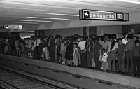
Temporary platform installed at Balderas station
Authorities warned on 10 August 2020 that Line1 is in danger of a major fire due to an aging electrical system that is in need of major improvements. Lines 1, 2, and 3 report an average of 2.5 electrical failures daily.[5] As a result, the line started undergo renovations that require its closure. The first closure was from Pantitlán to Salto de Agua stations starting on 11 July 2022 and it was expected to conclude in March 2023. The second closure was expected to start in March 2023 from Balderas to Observatorio stations and was expected to conclude in August 2023. During both periods, all railway elements will be replaced with modern material, the wiring will be replaced, damage due to leaks and cracks will be repaired, stations that are not yet modernized will be updated, and accessibility will be added to stations that lack it.[6][7]
In April 2023, Siemens Mobility claimed that they would install CBTC on Line 1.[8] On October 29, 2023, the modernized section of Line1 was inaugurated.[9] The second stage is expected to begin on 9November 2023.[10]
Chronology
September 4, 1969: from Chapultepec to Zaragoza.
April 11, 1970: from Chapultepec to Juanacatlán.
November 20, 1970: from Juanacatlán to Tacubaya.
June 10, 1972: from Tacubaya to Observatorio.
August 22, 1984: from Zaragoza to Pantitlán.
Rolling stock
Line 1 has had different types of rolling stock throughout the years.
↑ The following list was adapted from different websites and official maps.
Metro () connections obtained from the official Mexico City Metro system map.[12]
Accessibility obtained from the Mexico City Metro system map. In some cases, the map omits the accessibility icon as the station(s) are actually partially accessible. However, the respective websites of each station on the official site indicate the respective accessibility methods. Stations with the symbol ‡ are fully accessible; stations with the symbol † are partially accessible.[12]
Observatorio is an under-reconstruction station on Mexico City Metro Line 1. It is located in the Álvaro Obregón borough of Mexico City, west of the city centre. When operational it is the western terminus of Line 1. Before its shutdown for reconstruction, the station had an average ridership of 72,296 passengers per day, making it the eighth busiest station in the network.
Pantitlán metro station is a Mexico City Metro transfer station in the boroughs of Iztacalco and Venustiano Carranza, in Mexico City. It is a combined underground, at-grade, and elevated station with six island platforms and two side platforms, served by Lines 1, 5, 9, and A. The only quadra-line interchange station in the system, Pantitlán metro station works as the terminal station of all of the lines and is located followed by Zaragoza (Line 1), Hangares (Line 5), Puebla (Line 9), and Agrícola Oriental (Line A) stations. It serves the colonias (neighborhoods) of Ampliación Adolfo López Mateos, Aviación Civil, and Pantitlán; it receives its name from the last one. The station's pictogram features the silhouettes of two flagpoles.
Zaragoza metro station is a station of the Mexico City Metro in Venustiano Carranza, Mexico City. It is an underground station with two side platforms served by Line 1 between Gómez Farías and Pantitlán stations. It serves the colonias (neighborhoods) of 4 Árboles and Puebla. It lies below the Calzada Ignacio Zaragoza from which it receives its name, which in turn is named after Ignacio Zaragoza, the Secretary of War and Navy during the Battle of Puebla. The station's pictogram features a silhouette of the nearby equestrian statue that honors him.
Tacubaya is a station on Lines 1, 7 and 9 of the Mexico City Metro system. It is located in the Miguel Hidalgo borough, west of the city centre. In 2019, the station had a total average ridership of 85,800 passengers per day, making it the fifth busiest station in the network. Since 9 November 2023, the Line 1 station has remained closed for modernization work on the tunnel and the line's technical equipment.
Balbuena metro station is a station of the Mexico City Metro in Venustiano Carranza, Mexico City. It is an underground station with two side platforms served by Line 1 between Moctezuma and Boulevard Puerto Aéreo stations. It serves the colonias (neighborhoods) of Jardín Balbuena and Moctezuma 1ª sección, along Calzada Ignacio Zaragoza. The station's pictogram features the silhouette of four flowers with four petals each, in reference to the Balbuena Garden, found in the neighborhood of the same name, and from which the station takes its name.
Gómez Farías metro station is a station of the Mexico City Metro in Venustiano Carranza, Mexico City. It is an underground station with two side platforms served by Line 1 between Boulevard Puerto Aéreo and Zaragoza stations. It serves the colonias (neighborhoods) of Federal and Gómez Farías; the station receives its name from the latter, which in turn is named after Valentín Gómez Farías, the seventh president of Mexico. The pictogram depicts a representation of the Mexican Constitution of 1857, which was promoted by Gómez Farías during his tenure as the president of Congress. Gómez Farías metro station opened on 4 September 1969 with service westward toward Chapultepec station and eastward toward Zaragoza station. The facilities are partially accessible to people with disabilities as it has escalators. In 2019, the station had an average daily ridership of 28,385 passengers, making it the 48th busiest station in the network and the 11th busiest of the line. From July 2022 to October 2023, the station was closed due to modernization works on the tunnel and the line's technical equipment.
Line 5, also known as the Yellow Line from its color on the system map, is a rapid transit line of the Mexico City Metro network. It travels 15.6 kilometers (9.7 mi) along the boroughs of Gustavo A. Madero, Cuauhtémoc and Venustiano Carranza in northern, northeastern and eastern Mexico City, serving thirteen stations. The line was inaugurated on 19 December 1981, going from Pantitlán to Consulado station. In 1982, the line was expanded twice, first from Consulado to La Raza station on 1 July, and later from La Raza to Politécnico station on 30 August.
Line 2 is one of the 12 lines of the Mexico City Metro.
Mexico City Metro Line 3 is one of the 12 metro lines built in Mexico City, Mexico.
Mexico City Metro Line 4 is the fourth line of Mexico City Metro. The line color is aqua blue and it runs from north to south of the city crossing the city center by its easternmost area. In 2019 it had a total ridership of 29,013,032 passengers, making it the least used line on the system.
Mexico City Metro Line 6 is one of the twelve metro lines operating in Mexico City, Mexico. Its distinctive color is red. It was the sixth line to be opened.
Mexico City Metro Line 7 is one of the twelve metro lines operating in Mexico City, Mexico.
Mexico City Metro Line 8 is one of the twelve metro lines operating in Mexico City, Mexico. Its distinctive color is green.
Mexico City Metro Line 9 is one of the 12 metro lines built in Mexico City, Mexico.
Mexico City Metro Line A is one of the twelve metro lines operating in Mexico City, Mexico. The line's color is purple. It was the ninth line to be opened.
The Mexico City Metrobús Line 2 is a bus rapid transit line in the Mexico City Metrobus. It operates between Tepalcates, in Iztapalapa and Tacubaya in the Miguel Hidalgo municipality, in western Mexico City.
The Mexico City Metrobús Line 4 is a bus rapid transit line in the Mexico City Metrobus. It operates between Colonia Buenavista, in central Mexico City and the Mexico City International Airport in the Venustiano Carranza borough, in the east of the capital.
The Sistema de Transporte Público Cablebús, simply branded as Cablebús, is an aerial lift transport system that runs in the Gustavo A. Madero and Iztapalapa areas of Mexico City. It is operated by Servicio de Transportes Eléctricos, the agency responsible for the operation of all trolleybus and light rail services in Mexico City. Line 1 was officially inaugurated on 11 July 2021, going from the Indios Verdes station of the STC Metro to the northern neighborhoods of Gustavo A. Madero. Line 2 runs from the Constitución de 1917 to the Santa Marta STC Metro stations in the southeast of the city.
The Mexibús Line III is a bus rapid transit (BRT) line in the Mexibús system. It was the third line to be built and the second to be opened. It operates between Chimalhuacán, in the State of Mexico and Pantitlán metro station in Iztacalco and Venustiano Carranza, in Mexico City. It was inaugurated by the governor of the State of Mexico, Eruviel Ávila on 30 April 2013 with 29 stations. Another station was opened in 2019. In 2023, an extension was added from Chimalcuacán Municipality to Chicoloapan de Juárez. It is 23 kilometers (14 mi) long. The line operates with 85 articulated buses.
This page is based on this Wikipedia article Text is available under the CC BY-SA 4.0 license; additional terms may apply. Images, videos and audio are available under their respective licenses.