Related Research Articles

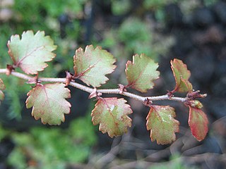
Nothofagus, also known as the southern beeches, is a genus of 43 species of trees and shrubs native to the Southern Hemisphere in southern South America and Australasia. The species are ecological dominants in many temperate forests in these regions. Some species are reportedly naturalised in Germany and Great Britain. The genus has a rich fossil record of leaves, cupules, and pollen, with fossils extending into the late Cretaceous period and occurring in Australia, New Zealand, Antarctica, and South America.
Antarctic flora are a distinct community of vascular plants which evolved millions of years ago on the supercontinent of Gondwana. Presently, species of Antarctica flora reside on several now separated areas of the Southern Hemisphere, including southern South America, southernmost Africa, New Zealand, Australia, and New Caledonia. Joseph Dalton Hooker was the first to notice similarities in the flora and speculated that Antarctica had served as either a source or a transitional point, and that land masses now separated might formerly have been adjacent.

Ranunculus is a large genus of about almost 1700 to more than 1800 species of flowering plants in the family Ranunculaceae. Members of the genus are known as buttercups, spearworts and water crowfoots.

The Antarctic Peninsula, known as O'Higgins Land in Chile and Tierra de San Martín in Argentina, and originally as Graham Land in the United Kingdom and the Palmer Peninsula in the United States, is the northernmost part of mainland Antarctica.
The Transantarctic Mountains comprise a mountain range of uplifted rock in Antarctica which extends, with some interruptions, across the continent from Cape Adare in northern Victoria Land to Coats Land. These mountains divide East Antarctica and West Antarctica. They include a number of separately named mountain groups, which are often again subdivided into smaller ranges.

The South Polar region of the Cretaceous comprised the continent of East Gondwana–modern day Australia and Antarctica–a product of the break-up of Gondwana in the Cretaceous Period. The southern region, during this time, was much warmer than it is today, ranging from perhaps 4–8 °C (39–46 °F) in the latest Cretaceous Maastrichtian in what is now southeastern Australia. This prevented permanent ice sheets from developing and fostered polar forests, which were largely dominated by conifers, cycads, and ferns, and relied on a temperate climate and heavy rainfall. Major fossil-bearing geological formations that record this area are: the Santa Marta and Sobral Formations of Seymour Island off the Antarctic Peninsula; the Snow Hill Island, Lopez de Bertodano, and the Hidden Lake Formations on James Ross Island also off the Antarctic Peninsula; and the Eumeralla and Wonthaggi Formations in Australia.
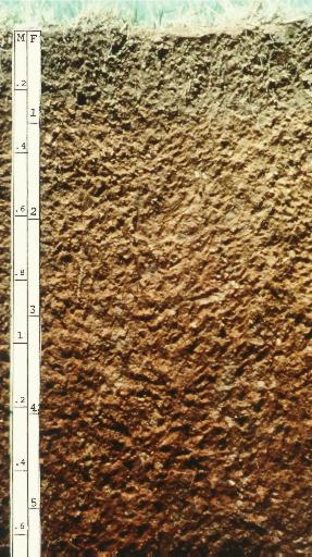
Alfisols are a soil order in USDA soil taxonomy. Alfisols form in semi-arid to humid areas, typically under a hardwood forest cover. They have a clay-enriched subsoil and relatively high native fertility. "Alf" refers to aluminium (Al) and iron (Fe). Because of their productivity and abundance, Alfisols represent one of the more important soil orders for food and fiber production. They are widely used both in agriculture and forestry, and are generally easier to keep fertile than other humid-climate soils, though those in Australia and Africa are still very deficient in nitrogen and available phosphorus. Those in monsoonal tropical regions, however, have a tendency to acidify when heavily cultivated, especially when nitrogenous fertilizers are used.

The geology of Antarctica covers the geological development of the continent through the Archean, Proterozoic and Phanerozoic eons.

The Hanson Formation is a geologic formation on Mount Kirkpatrick and north Victoria Land, Antarctica. It is one of the two major dinosaur-bearing rock groups found on Antarctica to date; the other is the Snow Hill Island Formation and related formations from the Late Cretaceous of the Antarctic Peninsula. The formation has yielded some Mesozoic specimens, but most of it is as yet unexcavated. Part of the Victoria Group of the Transantarctic Mountains, it lies below the Prebble Formation and above the Falla Formation. The formation includes material from volcanic activity linked to the Karoo-Ferar eruptions of the Lower Jurassic. The climate of the zone was similar to that of modern southern Chile, humid, with a temperature interval of 17–18 degrees. The Hanson Formation is correlated with the Section Peak Formation of the Eisenhower Range and Deep Freeze Range, as well as volcanic deposits on the Convoy Range and Ricker Hills of southern Victoria Land.

Glacialisaurus is a genus of sauropodomorph dinosaur. It lived during the Pliensbachian stage of the Early Jurassic period around 186 to 182 million years ago in what is now the central region of the Transantarctic Mountains of Antarctica. It is known from two specimens; the holotype, a partial tarsus (ankle) and metatarsus, and a partial left femur. The fossils were collected by a team led by paleontologist William R. Hammer during a 1990–91 field expedition to the Hanson Formation of Antarctica. They were described in 2007, and made the basis of the new genus and species Glacialisaurus hammeri. The genus name translates as “icy” or "frozen lizard”, and the species name honors Hammer.
The natural history of New Zealand began when the landmass Zealandia broke away from the supercontinent Gondwana in the Cretaceous period. Before this time, Zealandia shared its past with Australia and Antarctica. Since this separation, the New Zealand landscape has evolved in physical isolation, although much of its current biota has more recent connections with species on other landmasses. The exclusively natural history of the country ended in about 1300 AD, when humans first settled, and the country's environmental history began. The period from 1300 AD to today coincides with the extinction of many of New Zealand's unique species that had evolved there.

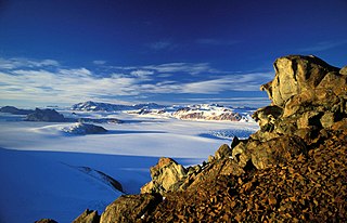
Antarctica is Earth's southernmost and least-populated continent. Situated almost entirely south of the Antarctic Circle and surrounded by the Southern Ocean, it contains the geographic South Pole. Antarctica is the fifth-largest continent, being about 40% larger than Europe, and has an area of 14,200,000 km2 (5,500,000 sq mi). Most of Antarctica is covered by the Antarctic ice sheet, with an average thickness of 1.9 km (1.2 mi).
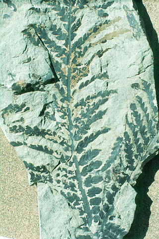
Dicroidium is an extinct genus of fork-leaved seed ferns that were widely distributed over Gondwana during the Triassic. Their fossils are known from South Africa, the Arabian Peninsula, Australia, New Zealand, South America, Madagascar, the Indian subcontinent and Antarctica. They were first discovered in Triassic sediments of Tasmania by Morris in 1845. Fossils from the Umm Irna Formation in Jordan and in Pakistan indicate that these plants already existed in Late Permian. Late surviving members of the genus are known from the Early Jurassic (Sinemurian) of East Antarctica. Within paleobotany, Dicroidium is a form genus used to refers to the leaves, associated with ovuluate organs classified as Umkomasia and pollen organs classified as Pteruchus, while Dicroidum is also used collectively to refer to the whole plant.
Citadel Bastion is a rocky, flat-topped, rocky elevation at the south side of the terminus of Saturn Glacier, facing towards George VI Sound and the Rymill Coast, situated on the east side of Alexander Island, Antarctica. Its maximum elevation is about 645 m. Citadel Bastion lies next to Hodgson Lake. This mountain was mapped from trimetrogon air photography taken by the Ronne Antarctic Research Expedition, 1947–48, and from survey by the Falkland Islands Dependencies Survey, 1948–50. The name applied by the UK Antarctic Place-Names Committee because it resembles a fortified structure with a watchtower at the end of a wall.
The Meyer Desert is a triangular ice-free area of about 50 square miles (130 km2) at the northern end of the Dominion Range, Antarctica, near the confluence of Beardmore Glacier and Mill Glacier. It was named by the New Zealand Geological Survey Antarctic Expedition of 1961–62 for George Meyer of the United States Antarctic Research Program, who was scientific leader at McMurdo Station in 1961, and led a field party into this area in the summer of 1961–62.

Gregory John Retallack is an Australian paleontologist, geologist, and author who specializes in the study of fossil soils (paleopedology). His research has examined the fossil record of soils though major events in Earth history, extending back some 4.6 billion years. Among his publications he has written two standard paleopedology textbooks, said N. Jones in Nature Geoscience "Retallack has literally written the book on ancient soils."

Lepidopteris is a form genus for leaves of Late Permian to Late Triassic Period Pteridospermatophyta, or seed ferns, which lived from around 260 to 200 million years ago in what is now Australia, Antarctica, India, South America, South Africa, Russia and China. Nine species are currently recognized. Lepidopteris was a common and widespread seed fern, which survived the Permian-Triassic extinction event but succumbed to the Triassic-Jurassic extinction event. Lepidopteris callipteroides is especially common between the first two episodes of Permian-Triassic extinction event, and L. ottonis forms a comparable acme zone immediate before the Triassic-Jurassic extinction event. Lepidopteris would persist into the Early Jurassic in Patagonia, represented by the species Lepidopteris scassoi.

Rosemary Anne Askin, also known as Rosemary Askin Cully, is a New Zealand geologist specialising in Antarctic palynology. She was a trailblazer for women in Antarctic science, becoming the first New Zealand woman to undertake her own research programme in Antarctica in 1970.

The Mawson Formation is a geological formation in Antarctica, dating to roughly between 182 and 177 million years ago and covering the Toarcian stages of the Jurassic Period in the Mesozoic Era. Vertebrate remains are known from the formation. The Mawson Formation is the South Victoria Land equivalent of the Karoo Large Igneous Province in South Africa, as well the Lonco Trapial Formation and the Cañadón Asfalto Formation of Argentina.
References
- ↑ Trewby, Mary, ed. (September 2002). Antarctica: An Encyclopedia from Abbott Ice Shelf to Zooplankton. Firefly Books. ISBN 1-55297-590-8.
- ↑ Retallack, G. J.; Krull, E. S.; Bockheim, J. G. (2001). "New grounds for reassessing palaeoclimate of the Sirius Group". Journal of the Geological Society, London. 158 (6): 925–35. doi:10.1144/0016-764901-030. S2CID 128906475.
- ↑ Stefi Weisburd (March 1986). "A forest grows in Antarctica. (an extensive forest may have flourished about 3 million years ago)". Science News. Retrieved 2012-11-02.