
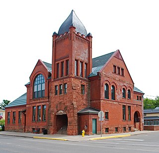
Marquette is the county seat of Marquette County and the largest city in the Upper Peninsula of Michigan, United States. Located on the shores of Lake Superior, Marquette is a major port known primarily for shipping iron ore from the Marquette Iron Range. The city is partially surrounded by Marquette Township, but the two are administered autonomously.

Marquette County is a county located in the Upper Peninsula of the U.S. state of Michigan. As of the 2020 census, the population was 66,017. It is the most populous county in the Upper Peninsula. The county seat is Marquette. The county is named for Father Marquette, a Jesuit missionary. It was set off in 1843 and organized in 1851.
Ishpeming is a city in Marquette County, Michigan, United States. Located in the Upper Peninsula, the population was 6,140 at the 2020 census, less than it was in the 1950s and 1960s when the Iron ore mines employed more workers. A statue of a Native American figure, erected in 1884 in the small town square, is referred to as "Old Ish".

Negaunee is a city in Marquette County in the U.S. state of Michigan. The population was 4,627 at the 2020 census. The city is located at the southwest corner of Negaunee Township, which is administratively separate, in the Upper Peninsula. The city is home to a luge track. The name "Negaunee" comes from an Anishinabemowin (Ojibwe) word nigani, meaning "foremost, in advance, leading," which was determined to be the closest Ojibwe translation for "pioneer". Within the city limits is Teal Lake.

The Iron Range is collectively or individually a number of elongated iron-ore mining districts around Lake Superior in the United States and Canada. Much of the ore-bearing region lies alongside the range of granite hills formed by the Giants Range batholith. These cherty iron ore deposits are Precambrian in the Vermilion Range and middle Precambrian in the Mesabi and Cuyuna ranges, all in Minnesota. The Gogebic Range in Wisconsin and the Marquette Iron Range and Menominee Range in Michigan have similar characteristics and are of similar age. Natural ores and concentrates were produced from 1848 until the mid-1950s, when taconites and jaspers were concentrated and pelletized, and started to become the major source of iron production.
M-35 is a state trunkline highway in the Upper Peninsula (UP) of the US state of Michigan. It runs for 128 miles (206 km) in a general north–south direction and connects the cities of Menominee, Escanaba, and Negaunee. The southern section of M-35 in Menominee and Delta counties carries two additional designations; M-35 forms a segment of the Lake Michigan Circle Tour, and it is the UP Hidden Coast Recreational Heritage Trail, which is a part of what is now called the Pure Michigan Byways Program. Along the southern section, the highway is the closest trunkline to the Green Bay, a section of Lake Michigan. The northern section of the highway turns inland through sylvan areas of the UP, connecting rural portions of Delta and Marquette counties.
The Cliffs Shaft Mine Museum is a former iron mine, now a heritage museum, located on Euclid Street between Lakeshore Drive and Spruce Street in Ishpeming, Michigan. The museum, operated by "Marquette Range Iron Mining Heritage Theme Park Inc.", celebrates the history of the Marquette Iron Range. The site was designated a state of Michigan historic site in 1973 and placed on the National Register of Historic Places in 1992.
The Gogebic Range is an elongated area of iron ore deposits located within a range of hills in northern Michigan and Wisconsin just south of Lake Superior. It extends from Lake Namakagon in Wisconsin eastward to Lake Gogebic in Michigan, or almost 80 miles. Though long, it is only about a half mile wide and forms a crescent concave to the southeast. The Gogebic Range includes the communities of Bessemer and Ironwood in Michigan, plus Mellen and Hurley in Wisconsin.
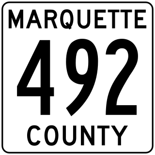
County Road 492 is a primary county road in Marquette County, Michigan. The road serves as an alternate route between Negaunee and Marquette. Several historic sites line the roadway as it runs south and parallel to the main highway, U.S. Highway 41 (US 41) and M-28, through the Marquette Iron Range in Michigan's Upper Peninsula. The path of the road runs near tracks of the Lake Superior and Ishpeming Railroad (LS&I). The locally created Iron Ore Heritage Trail will follow CR 492 through Eagle Mills and Morgan Meadows upon completion. The western terminus of the county road is on US 41/M-28 in Negaunee and the eastern end is in Marquette next to Lake Superior.
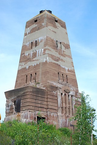
The Marquette Iron Range is a deposit of iron ore located in Marquette County, Michigan in the United States. The towns of Ishpeming and Negaunee developed as a result of mining this deposit. A smaller counterpart of Minnesota's Mesabi Range, this is one of two iron ranges in the Lake Superior basin that are in active production as of 2018. The iron ore of the Marquette Range has been mined continuously from 1847 until the present day. Marquette Iron Range is the deposit's popular and commercial name; it is also known to geologists as the Negaunee Iron Formation.
Carp River is the name of several rivers in the U.S. state of Michigan.
Carp River is a 21.9-mile-long (35.2 km) river in Marquette County in the U.S. state of Michigan. The Carp River is formed by the outflow of Deer Lake in Ishpeming Township north of Ishpeming at 46°31′58″N87°40′01″W in the Upper Peninsula.

The Jackson Mine is an open pit iron mine in Negaunee, Michigan, extracting resources from the Marquette Iron Range. The first iron mine in the Lake Superior region, Jackson Mine was designated as a Michigan State Historic Site in 1956 and listed on the National Register of Historic Places in 1971. The Lake Superior Mining Institute said, the mine "is attractive in the iron ore region of Michigan and the entire Lake Superior region, because of the fact it was here that the first discovery of iron ore was made, here the first mining was done, and from its ore the first iron was manufactured." Multiple other mines soon followed the Jackson's lead, establishing the foundation of the economy of the entire region. The mine is located northwest of intersection of Business M-28 and Cornish Town Road.

The Carp River Forge is an abandoned iron forge located along the Carp River on the grounds of the Michigan Iron Industry Museum, at 73 Forge Road near Negaunee, Michigan. It was the first forge constructed in northern Michigan; the site was designated a Michigan State Historic Site in 1956 and listed on the National Register of Historic Places in 1975. It is also known as the Jackson Iron Company Site.

Peter White was one of the original settlers of Marquette, Michigan. He was a banker, businessman, real estate developer, and a philanthropist; and was involved in a number of the area's iron mining-related businesses, including acting as a director the Cleveland Iron Company. White served in many local and state public offices, including postmaster, county clerk, school board member, state representative and senator, and as a member of the state library commission and a Regent of the University of Michigan. Poet William Henry Drummond said of White, "the trail Peter White has cut through life is blessed by acts of private charity and deeds of public devotion that will serve as a guide to those who follow in the footsteps of a truly great, and above all, good man."

The Iron County MRA is a Multiple Resource Area addition to the National Register of Historic Places, which includes 72 separate structures and historic districts within Iron County, Michigan, United States of America. These properties were identified and placed on the Register in 1983, with the exception of one property that was placed on the Register in 1993.
The Breitung Hotel, named for Edward Breitung, was a hotel at 111 South Pioneer Avenue in Negaunee, Michigan. The hotel, designed by David M. Harteau, was built from 1879 to 1880. The building was listed as a Michigan State Historic Site on June 20, 1985.
The Iron Ore Heritage Trail is a 47-mile (76 km) bicycle and hiking trail in Michigan that presents a look at some of the key sites of human and geological heritage on the Marquette Iron Range. Trailheads are located at the Marquette Welcome Center in Marquette, and in Republic west of Marquette. The trail, which has a comparative change in elevation of 1,000 feet (300 m) covers much of the length of the Marquette Iron Range, a historically and commercially significant range of hematite and magnetite mined for more than 150 years as iron ore. The trail celebrates the geological and human heritage of the Marquette Iron Range, which dominated U.S. iron ore production from approximately 1880 until about 1900. Many of the buildings visible from the trail date back to this period of Victorian architecture. Additional focal points/parking lots for the trail are located at midpoints at the Michigan Iron Industry Museum in Negaunee and the Cliffs Shaft Mine Museum in Ishpeming.

The Ore Dock Brewing Company is a craft brewery in Marquette, Michigan, that opened in May 2012. Named for a nearby local landmark, the brewery is known for being a "Marquette focal point and tourist destination," in the words of historian Russell Magnaghi.
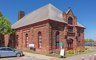
The Marquette Maritime Museum is a museum and lighthouse located in Marquette in the U.S. state of Michigan. Since 2002, the museum has been associated with the Marquette Harbor Light, a lighthouse that serves traffic in Marquette Harbor and adjacent waters of Lake Superior. The facility offers tours of the lighthouse, which remains an active aid to navigation overseen by the United States Coast Guard, and the museum specializes in the maritime history of Marquette, Lake Superior, and the iron ore trade. Lake Superior is one of the five Great Lakes.

