
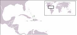
The Turks and Caicos Islands are a British Overseas Territory consisting of the larger Caicos Islands and smaller Turks Islands, two groups of tropical islands in the Lucayan Archipelago of the Atlantic Ocean and northern West Indies. They are known primarily for tourism and as an offshore financial centre. The resident population in 2023 was estimated by The World Factbook at 59,367, making it the third-largest of the British overseas territories by population. However, according to a Department of Statistics estimate in 2022, the population was 47,720.
The Lucayan people were the original residents of The Bahamas before the European conquest of the Americas. They were a branch of the Taínos who inhabited most of the Caribbean islands at the time. The Lucayans were the first indigenous Americans encountered by Christopher Columbus. Shortly after contact, the Spanish kidnapped and enslaved Lucayans, with the displacement culminating in the complete eradication of the Lucayan people from the Bahamas by 1520.

Andros Island is an archipelago within the Bahamas, the largest of the Bahamian Islands. Politically considered a single island, Andros in total has an area greater than all the other 700 Bahamian islands combined. The land area of Andros consists of hundreds of small islets and cays connected by mangrove estuaries and tidal swamplands, together with three major islands: North Andros, Mangrove Cay, and South Andros. The three main islands are separated by bights, estuaries that trifurcate the island from east to west. It is 167 kilometres (104 mi) long by 64 km (40 mi) wide at the widest point.
Cockburn Town is the capital of the Turks and Caicos Islands, spreading across most of Grand Turk Island. It was founded in 1681 by salt collectors.

Acklins is an island and district of the Bahamas.

The Lucayan Archipelago, also known as the Bahamian Archipelago, is an island group comprising the Commonwealth of The Bahamas and the British Overseas Territory of the Turks and Caicos Islands. The archipelago is in the western North Atlantic Ocean, north of Cuba and the other Antillean Islands, and east and south-east of Florida.

Providenciales is an island in the northwest Caicos Islands, part of the Turks and Caicos Islands, a British Overseas Territory. The island has an area of 98 km2 (38 sq mi) and a 2012 Census population of 23,769. Providenciales is the third largest island in the Turks and Caicos in area, and is home to a large majority of the population of the Turks and Caicos Islands.

South Caicos is the seventh-largest island in the Turks and Caicos archipelago, with a land area of 21.2 square kilometres. South Caicos is known for excellent fishing, both deep-sea and bone fishing, and scuba diving. South Caicos was formerly a salt exporter, the island still hosts a network of salt pans as a reminder of the industry. Today, the island's main income is derived from small-scale commercial fishing.

North Caicos is the second-largest island in the Turks and Caicos Islands. To the west, the Caicos Cays link to Providenciales. To the east, it is separated from Middle Caicos by Juniper Hole, a narrow passage that can accommodate only small boats. A 1600-m (1-mile) causeway connects North Caicos to Middle Caicos.

The West Indies is a subregion of North America, surrounded by the North Atlantic Ocean and the Caribbean Sea, which comprises 13 independent island countries and 19 dependencies in three archipelagos: the Greater Antilles, the Lesser Antilles, and the Lucayan Archipelago.

East Caicos is the fourth largest island in the Turks and Caicos Islands. To the west, it is separated from Middle Caicos by Lorimer Creek, a narrow passage that can accommodate only small boats. To the south is South Caicos. East Caicos has no inhabitants.
Trouvadore was a Spanish slave ship that was shipwrecked in 1841 near East Caicos in the course of a run transporting Africans to be illegally sold to the sugarcane plantations in Cuba. As the United Kingdom had a treaty with Spain prohibiting the international slave trade and had abolished slavery in its colonies in 1833, it freed the 192 slaves who survived the wreck. Individuals and families, a total of 168 Africans, were placed with salt proprietors for apprenticeships in the Turks and Caicos Islands; the remaining 24 Africans were settled in Nassau.

Big Ambergris Cay is a private residential island and home to Ambergris Cay Private Island Resort, located within the Turks and Caicos Islands. Not to be confused with Ambergris Caye in Belize, Big Ambergris Cay is situated to the southeast of the main chain of the Caicos islands. Adjacent to Big Ambergris Cay is Little Ambergris Cay, which is an uninhabited natural reserve. Little Ambergris Cay is a unique and significant habitat for a wide range of birds and marine life. Big Ambergris Cay island is approximately four miles long, one mile wide, and 1,100 acres (4.5 km2) in total.
The following is an alphabetical list of topics related to the British Overseas Territory of the Turks and Caicos Islands.

Archaeology of Samoa began with the first systematic survey of archaeological remains on Savai'i island by Jack Golson in 1957. Since then, surveys and studies in the rest of Samoa have uncovered major findings of settlements, stone and earth mounds including star mounds, Lapita pottery remains and pre-historic artifacts.
The Conch Bar Caves, located on Middle Caicos, is the largest above-ground cave system in the Bahamas-Turks and Caicos Islands archipelago.
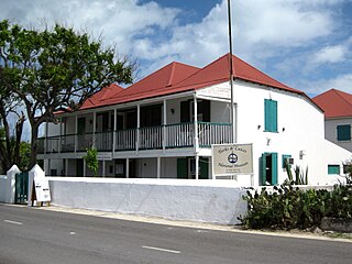
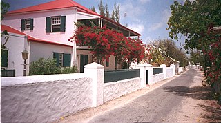
The Turks and Caicos National Museum is the national museum of the Turks and Caicos Islands. It is located in Guinep House on Front Street to the north of Cockburn Town on Grand Turk Island, which is also the capital of the archipelago. Established in the 1980s and opened in 1991, the museum is publicly funded as a nonprofit trust. It exhibits pre-historic Lucayan culture and records the history of the islands of the colonial era and the slave trade, all related to the sea. An arboretum is adjacent to the museum.

The Fish Ponds and Crossing Place Trail Important Bird Area is a 1024 ha tract of land on the island of Middle Caicos in the Turks and Caicos Islands, a British Overseas Territory in the Lucayan Archipelago of the western Atlantic Ocean. It forms one of the territory's Important Bird Areas (IBAs).

Tourism in the Turks and Caicos Islands is an industry that generates more than 1 million tourist arrivals per year, and is "the main source of revenue for the country. The tourism industry began in the 1980s, with the opening of Club Med Turquoise, the country's first main resort." "Tourism has benefited from the proximity to the United States and the stability via being a British Overseas Territory. The opening of a cruise port on Grand Turk in 2006 resulted in a significant increase in tourism arrivals to the country."
Chelonoidis alburyorum is an extinct species of giant tortoise that lived in the Lucayan Archipelago from the Late Pleistocene to around 1400 CE. The species was discovered and described by Richard Franz and Shelley E. Franz, the findings being published in 2009.


