
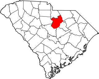
Kershaw County is a county located in the U.S. state of South Carolina. As of the 2020 census, its population was 65,403. The county seat and largest city is Camden. The county was created in 1791 from parts of Claremont, Lancaster, Fairfield, and Richland counties. It is named for Col. Joseph Kershaw (1727–1791), an early settler and American Revolutionary War patriot.

Boykins is a town in Southampton County, Virginia, United States. The population was 564 at the 2010 census.

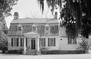
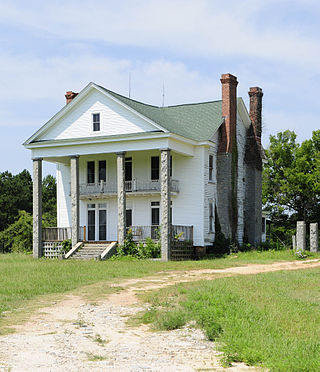
Mulberry Plantation, also known as the James and Mary Boykin Chesnut House is a historic plantation at 559 Sumter Highway south of Camden, South Carolina. Declared a National Historic Landmark in 2000, it is significant as the home of American Civil War chronicler Mary Boykin Chesnut, who produced some of the most important written accounts of the war from a Confederate perspective. The main house, built about 1820, is a fine example of Federal period architecture.
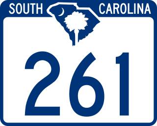
South Carolina Highway 261 (SC 261) is a 116.960-mile (188.229 km) state highway in the U.S. state of South Carolina. It travels between Yauhannah in Georgetown County to Kershaw County. Although the highway covers more east–west distance, it is signed north–south.

The High Hills of Santee, sometimes known as the High Hills of the Santee, is a long, narrow hilly region in the western part of Sumter County, South Carolina. It has been called "one of the state's most famous areas". The High Hills of Santee region lies north of the Santee River and east of the Wateree River, one of the two rivers that join to form the Santee. It extends north almost to the Kershaw county line and northeasterly to include the former summer resort town of Bradford Springs. Since 1902 the town has been included in Lee County.

Cedar Crest, also known as Cedar Crest Farms, is a Greek Revival plantation house located near Faunsdale, Alabama. It was built for Kimbrough Cassels Dubose in 1850 by Albert Prince, a slave. Dubose, born in Darlington District, South Carolina was educated at the preparatory school of Prof. Stafford who later was of the faculty of the University of Alabama. His wife was Miss Elizabeth Boykin Witherspoon also of Darlington District, South Carolina, and they had seven sons and four daughters: John Witherspoon, James Henry, Jr., Eugene, Nicholas William, Francis Marion, Lemuel Benton and Edwin Dargan-the daughters Louisa, Rosalie, Augusta and Adele. The plantation was worked by the forced labor of as many as 130 enslaved persons. The house is one-and-a-half stories with side gables, but has been simplified. It originally had side wings, with adjoining porches across the front. These were removed in 1939, leaving the small central front portico. Another historic plantation house, Altwood, was moved from a nearby location to the Cedar Crest grounds in 1988. The house was added to the National Register of Historic Places on August 5, 1993, as a part of the Plantation Houses of the Alabama Canebrake and Their Associated Outbuildings Multiple Property Submission.
Carter Hill is a historic plantation complex located near Camden, Kershaw County, South Carolina. The overseer's house was built about 1840, and now incorporated into the main house built about 1875. The overseer's house was a one-room house, that incorporates architectural elements in the Greek Revival style. The main house reflects the rural Victorian architectural style predominant after the American Civil War. Also on the property are a log building, a frame building, a pump house, a smokehouse, a dovecote, a hen house, and a barn constructed at various times during the 19th century. It was listed on the National Register of Historic Places in 1992.

Orange Grove, also known as the Gaillard-Colclough House, is an historic 39.9-acre (161,000 m2) plantation and its plantation house at Gaillard's Crossroads,, north of Dalzell, South Carolina. It was added to the National Register of Historic Places on August 19, 1993.
The Oakland Plantation House which is also known as Youghall or Youghal Plantation House, was built about 1750 in Charleston County, South Carolina about 7 mi (11 km) east of Mount Pleasant. It is located about 1 mile (1.6 km) south of U.S. Route 17 on Stratton Place. It was named to the National Register of Historic Places on July 13, 1977.
This is a list of the National Register of Historic Places listings in Kershaw County, South Carolina.
Frogmore is a plantation house on Edisto Island, South Carolina, built by Waccamaw's Dr. Edward Mitchell in approximately 1820 following his marriage to Edisto Island's Elizabeth Baynard.
Boykin is a census-designated place and unincorporated community in Kershaw County, South Carolina, United States. Its population was 100 as of the 2010 census. Boykin is located on South Carolina Highway 261, 9 miles (14 km) south of Camden. It is named for John Boykin, an early resident.
The McDowell Site, also known as Chesnut Mounds, Taylor Mounds, and Mulberry Plantation House, is a set of historic mounds located near Camden, Kershaw County, South Carolina. The McDowell Site is among the first archaeological sites to be carefully excavated and archaeologically reported in the United States. It represents a widespread late prehistoric Indian culture known by the names of Lamar, Irene, and Pee Dee, and possibly extends into protohistoric and historic times. It probably dates between AD 1400 and AD 1700.

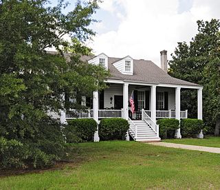
Cool Springs is a historic home located near Camden, Kershaw County, South Carolina. It was built about 1832, and is a two-story Greek Revival style house on a raise brick basement. The original house was remodeled in the 1850s. It features a tiered portico and verandahs, supported by 64 Doric order columns. A two-story kitchen addition was attached to the house about 1935. Also on the property are the contributing two horse stables, a concrete piscatory, an old stone spring, a brick basin, a dam, and granite gate posts.

Thomas English House, also known as the Murchison House, is a historic home located at Camden, Kershaw County, South Carolina. It was built about 1800, and is a two-story, five-bay, hip-roofed, frame and beaded weatherboard Federal I-house. It is set on brick piers connected by a recessed, stucco-covered, concrete block curtain wall. The front façade features a one-story, full-length, hip-roofed porch.
Zachariah Cantey House, also known as Buckton, is a historic home located near Camden, Kershaw County, South Carolina. It was built about 1795, and is a rectangular, 1+1⁄2-story Federal hall and parlor dwelling. It has a hewn-timber braced frame; beaded weatherboard siding; a tall, brick pier foundation and a gable roof. Zachariah Cantey was a prominent local planter, businessman, and politician.
Benjamin McCoy House, also known as Banbury Cross, is a historic home located near Cassatt, Kershaw County, South Carolina. It was built about 1820, and is a two-story I-house. It has heavy timber-frame construction and brick exterior brick chimneys.
Russell-Heath House is a historic home located near Stoneboro, Kershaw County, South Carolina. It was built about 1830, and renovated about 1906. The main block is a two-story, rectangular structure with a lateral gable roof and a one-story, gable-roof wing. It has clapboard siding and a brick pier foundation. The façade has a projecting Classical Revival portico with four granite pillars. Also on the property are two contributing early-20th century, vertical plank sheds.
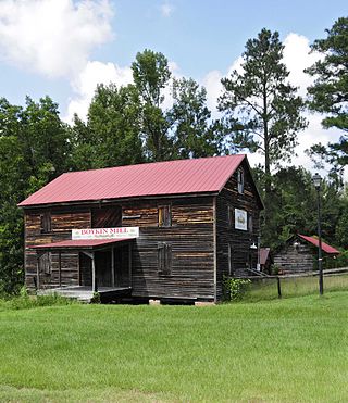
Boykin Mill Complex, also known as Mill Tract Plantation, is a national historic district located near Camden, Kershaw County, South Carolina. The district encompasses nine contributing buildings, two contributing sites, and four contributing structures. “Boykin Mill” denotes a community which consists of an old post office, an old general store, a c. 1905 grist mill, mill pond, mill dam, gates, and canals. The community also includes an early 19th-century Greek Revival style Baptist church, one mid-19th-century residence, three 20th-century residences built for mill workers, and a smoke house. An American Civil War battle site is also a part of the Boykin Mill community. The Battle of Boykin's Mill took place on April 17, 1865.


