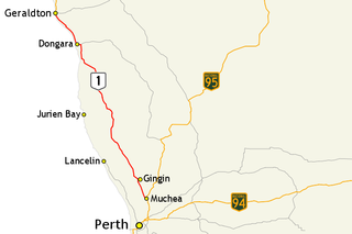
Brand Highway is a 370-kilometre (230 mi) main highway linking the northern outskirts of Perth to Geraldton in Western Australia. Together with North West Coastal Highway, it forms part of the Western Australian coastal link to the Northern Territory. The highway is a part of Australia's Highway 1, and is for the most part a single carriageway with one lane in each direction.
Walkaway is a small town in the City of Greater Geraldton local government area of Western Australia. At the 2016 census, Walkaway had a population of 270.

Mullewa is a town in the Mid West region of Western Australia, 450 kilometres (280 mi) north of Perth and 98 kilometres (61 mi) east-northeast of Geraldton. Mullewa is well known for an abundance of wildflowers in spring and it is one of the few places in Western Australia that the wreath flower grows. The surrounding areas produce wheat and other cereal crops. The town is a receival site for Cooperative Bulk Handling.

Eneabba is a town on the Brand Highway 278 kilometres (173 mi) north of Perth, Western Australia.
Western Australian Government Railways (WAGR) was the operator of railway services in the state of Western Australia between October 1890 and June 2003. Owned by the state government, it was renamed a number of times to reflect extra responsibility for tram and ferry operations that it assumed and later relinquished. Its freight operations were privatised in December 2000 with the remaining passenger operations transferred to the Public Transport Authority in July 2003.

Three Springs is a town located 313 kilometres (194 mi) north of Perth, Western Australia on the Midlands Road, which until the opening of the Brand Highway in 1975 was the main road route from Perth to the state's north. The town is the seat of the Shire of Three Springs. Its economy is based on agriculture and mining.

The Midland Railway of Western Australia (MRWA) was a railway company that built and operated the Midland line in Western Australia. It was listed on the London Stock Exchange. Although having its headquarters in London, it had no association with the English Midland Railway.

Carnamah is a town in the Mid West region of Western Australia, about 307 kilometres (191 mi) north of Perth along the Midlands Road. According to 2006 census, the population of the town is approximately 496.

Railways in Western Australia were developed in the 19th century both by the Government of Western Australia and a number of private companies. Today passenger rail services are controlled by the Public Transport Authority through Transperth, which operates public transport in Perth, and Transwa, which operates country passenger services. Great Southern Rail operates the Indian Pacific.
The Northern Railway has had a number of meanings in Western Australian railway history.

The South Western Railway, also known as the South West Main Line, is the main railway route between Perth and Bunbury in Western Australia.

The Shire of Carnamah is a local government area located in the Mid West region of Western Australia, about 310 kilometres (193 mi) north of Perth, the state capital, and about 181 kilometres (112 mi) south of the city of Geraldton. The Shire covers an area of 2,876 square kilometres (1,110 sq mi) and its seat of government is the town of Carnamah.

The Shire of Mingenew is a local government area in the Mid West region of Western Australia, about 110 kilometres (68 mi) southeast of the city of Geraldton and about 370 kilometres (230 mi) north of the state capital, Perth. The Shire covers an area of 1,939 square kilometres (749 sq mi), and its seat of government is the town of Mingenew.

The Shire of Three Springs is a local government area in the Mid West region of Western Australia, about 310 kilometres (193 mi) north of the state capital Perth. The Shire covers an area of 2,657 square kilometres (1,026 sq mi), and its seat of government is the town of Three Springs.
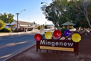
Mingenew is a town in Western Australia, located 383 kilometres (238 mi) north of the state capital, Perth. It is the seat of government for the Shire of Mingenew.

Yuna is a small town in the Mid West region of Western Australia, in the Shire of Chapman Valley, 62 kilometres (39 mi) northeast of the city of Geraldton.
Arrino is a small town in the Mid West region of Western Australia. The town is located between Mingenew and Three Springs on the Midlands Road.

Western Australian Government Railways railway system during its peak operational time in the 1930s to 1950s was a large system of over 6,400 kilometres (4,000 mi) of railway line.
Main Roads Western Australia controls the major roads in the state's Mid West region. There are four main highways through the Mid West: The north-south coastal route of Brand Highway and North West Coastal Highway, the inland alternative Great Northern Highway, and the northern section of Goldfields Highway, which links Meekatharra with Kalgoorlie. A network of main roads connects towns within the Mid West to each other, the highways, and neighbouring regions, with local roads providing additional links and access to smaller townsites. Roads are often named after the towns they connect.
The Midlander was an overnight passenger train operated by the Western Australian Government Railways between Perth and Geraldton via the Midland line from September 1964 until July 1975.
