
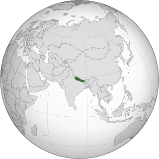
Nepal measures about 880 kilometers (547 mi) along its Himalayan axis by 150 to 250 kilometers across. It has an area of 147,516 km2 (56,956 sq mi).

The current population of Nepal is 29,164,578 as per the 2021 census. The population growth rate is 0.92% per year.

Rural flight is the migratory pattern of people from rural areas into urban areas. It is urbanization seen from the rural perspective.

The Dust Bowl was the result of a period of severe dust storms that greatly damaged the ecology and agriculture of the American and Canadian prairies during the 1930s. The phenomenon was caused by a combination of natural factors and human-made factors: a failure to apply dryland farming methods to prevent wind erosion, most notably the destruction of the natural topsoil by settlers in the region. The drought came in three waves: 1934, 1936, and 1939–1940, but some regions of the High Plains experienced drought conditions for as long as eight years.

The Great Migration, sometimes known as the Great Northward Migration or the Black Migration, was the movement of six million African Americans out of the rural Southern United States to the urban Northeast, Midwest, and West between 1910 and 1970. It was substantially caused by poor economic and social conditions due to prevalent racial segregation and discrimination in the Southern states where Jim Crow laws were upheld. In particular, continued lynchings motivated a portion of the migrants, as African Americans searched for social reprieve. The historic change brought by the migration was amplified because the migrants, for the most part, moved to the then-largest cities in the United States at a time when those cities had a central cultural, social, political, and economic influence over the United States; there, African-Americans established culturally influential communities of their own. According to Isabel Wilkerson, despite the loss of leaving their homes in the South, and the barriers faced by the migrants in their new homes, the migration was an act of individual and collective agency, which changed the course of American history, a "declaration of independence" written by their actions.
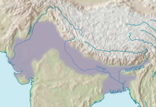
The Indo-Gangetic Plain, also known as the North Indian River Plain, is a 700-thousand km2 (172-million-acre) fertile plain encompassing northern regions of the Indian subcontinent, including most of modern-day northern and eastern India, most of eastern-Pakistan, virtually all of Bangladesh and southern plains of Nepal. Also known as the Indus–Ganga Plain, the region is named after the Indus and the Ganges rivers and encompasses a number of large urban areas. The plain is bounded on the north by the Himalayas, which feed its numerous rivers and are the source of the fertile alluvium deposited across the region by the two river systems. The southern edge of the plain is marked by the Deccan Plateau. On the west rises the Iranian Plateau. Many developed cities like Delhi, Dhaka, Kolkata, Lahore, Islamabad and Karachi are located in the Indo-Gangetic Plain.
Hukou is a system of household registration used in mainland China. The system itself is more properly called "huji", and has origins in ancient China; hukou is the registration of an individual in the system. A household registration record officially identifies a person as a permanent resident of an area and includes identifying information such as name, parents, spouse and date of birth. A hukou can also refer to a family register in many contexts since the household register is issued per family, and usually includes the births, deaths, marriages, divorces, and moves, of all members in the family.

The Terai or Tarai is to a lowland region in parts of northern India and southern Nepal that lies to the south of the outer foothills of the Himalayas, the Sivalik Hills and north of the Indo-Gangetic Plain. This lowland belt is characterised by tall grasslands, scrub savannah, sal forests and clay rich swamps. In North India, the Terai spreads from the Yamuna River eastward across Haryana, Uttarakhand, Uttar Pradesh, Bihar and West Bengal. The Terai is part of the Terai-Duar savanna and grasslands ecoregion. Nepal's Terai stretches over 33,998.8 km2 (13,127.0 sq mi), about 23.1% of Nepal's land area, and lies at an elevation of between 67 and 300 m. The region comprises more than 50 wetlands. North of the Terai rises the Bhabar, a narrow but continuous belt of forest about 8–12 km (5.0–7.5 mi) wide.

A migrant worker is a person who migrates within a home country or outside it to pursue work. Migrant workers usually do not have an intention to stay permanently in the country or region in which they work.

The History of Darjeeling covers the history of Darjeeling town and its adjoining hill areas belonging to Sikkim, but eventually part of British India so now in the Indian state of West Bengal, which is intertwined with the history of Nepal, Sikkim, Bhutan, Bengal and Great Britain. Part of the state of Sikkim, Darjeeling became part of an important buffer state between Nepal and Bhutan. The British, using the area as a sanitorium, found that the climate provided excellent tea-cultivating conditions and soon began to grow tea on the hills of Darjeeling. Darjeeling tea remains a world-renowned export from Darjeeling.
Madheshi people is a term used for several ethnic groups in Nepal living in the central and eastern Terai region of Nepal. It has also been used as a political pejorative term by the Pahari people of Nepal to refer to Nepalis with a non-Nepali language as their mother tongue, regardless of their place of birth or residence. The term Madheshi became a widely recognised name also for Nepali citizens with an Indian cultural background only after 1990. Madheshi people comprise various cultural groups such as Hindu caste groups, Muslims, Marwaris, Brahmin and Dalit caste groups, ethnic groups like Maithils, Bhojpuri, Awadhi and Bajjika speaking people and indigenous people of the Terai. Many of these groups share cultural traditions, educational and family ties with people living south of the international border in Bihar, Uttar Pradesh and West Bengal. Tharu people and Pahari people living in the Terai do not consider themselves as Madheshi. In recent times, some politicians and journalists use the term for all Nepali citizens of the Terai.

In the context of the 20th-century history of the United States, the Second Great Migration was the migration of more than 5 million African Americans from the South to the Northeast, Midwest and West. It began in 1940, through World War II, and lasted until 1970. It was much larger and of a different character than the first Great Migration (1916–1940), where the migrants were mainly rural farmers from the South and only came to the Northeast and Midwest.

Circular migration or repeat migration is the temporary and usually repetitive movement of a migrant worker between home and host areas, typically for the purpose of employment. It represents an established pattern of population mobility, whether cross-country or rural-urban. There are several benefits associated with this migration pattern, including gains in financial capital, human capital, and social capital. There are also costs associated with circular migration, such as brain drain, poor working conditions, forced labor, and the inability to transfer acquired skills to home economies. Socially, there are strong connections to gender, health outcomes, development, poverty, and global immigration policy.
Urban Appalachians are people from or with close ancestral ties to Appalachia who are living in metropolitan areas outside of the region. Because migration has been occurring for decades, most are not first generation migrants from the region but are long-term city dwellers. People have been migrating from Appalachia to cities outside the region ever since many of these cities were founded. It was not until the period following World War II, however, that large-scale migration to urban areas became common due to the decline of coal mining and the increase in industrial jobs available in the Midwest and Northeast. The migration of Appalachians is often known as the Hillbilly Highway.

Urbanization in China increased in speed following the initiation of the reform and opening policy. By the end of 2023, China had an urbanization rate of 66.2% and is expected to reach 75-80% by 2035.
Internal migration in the People's Republic of China is one of the most extensive in the world according to the International Labour Organization. This is because migrants in China are commonly members of a floating population, which refers primarily to migrants in China without local household registration status through the Chinese Hukou system. In general, rural-urban migrant most excluded from local educational resources, citywide social welfare programs and many jobs because of their lack of hukou status. Migrant workers are not necessarily rural workers; they can simply be people living in urban areas with rural household registration.
The Inner Terai Valleys of Nepal comprise several elongated river valleys in the southern lowland Terai part of the country. These tropical valleys are enclosed by the Himalayan foothills, viz the Mahabharat Range and the Sivalik Hills farther south.
Religion and human migration have been intertwined throughout history. Religious demography changes are often the consequences, and sometimes the goals, resulting from mass migration to other territories. Often, political migration aims to establish a territory and governments biased towards and welcoming of sect members. Religious beliefs and practices have served as significant motivations for migration, with people seeking religious freedom or fleeing ][religious persecution]]. This interaction of religion and migration has led to the spread and diversity of religions around the world, as well as the emergence of new religious practices and beliefs as people adapt to new environments and interact with different cultures.

Koshi Province is the autonomous easternmost province adopted on 20 September 2015 by Constitution of Nepal. The province is rich in natural resources, tourist attractions, recreational activities, and natural beauty. The province covers an area of 25,905 km2 (10,002 sq mi), about 17.5% of the country's total area. With the industrial city of Biratnagar as its capital, the province includes major eastern towns of Birtamod, Sundar Haraincha, Damak, Dharan, Itahari, Triyuga Municipality and Mechinagar, and the Mount Everest, Kangchenjunga and Ama Dablam. Koshi River, the largest river of the nation, forms the province's western boundary. Under the First-past-the-post voting system issued by the Constituency Delimitation Commission, Nepal, the province hosts 28 parliamentary seats and 56 provincial assembly seats.
Squatting in Nepal occurs when people live on land or in buildings without the valid land ownership certificate. The number of squatters has increased rapidly since the 1980s, as a result of factors such as internal migration to Kathmandu and two decades of civil war in Nepal. In March 2021, the chairperson of the Commission on Landless Squatters stated that all landless squatters would receive ownership certificates within the following eighteen months.