Mijikenda peoples

Last updated
Mijikenda
Giriama commemorative posts (1).jpg
Total population
2,488,691 (Kenya) [1]
Regions with significant populations
Flag of Kenya.svg  Kenya Flag of Tanzania.svg  Tanzania
Languages
MijikendaSwahiliEnglish
Related ethnic groups
Pokomo, Chonyi, Digo, Giriama, Jibana, Swahili, other Bantu peoples

Mijikenda ("the Nine Tribes") are a group of nine related Bantu ethnic groups inhabiting the coast of Kenya, between the Sabaki and the Umba rivers, in an area stretching from the border with Tanzania in the south to the border near Somalia in the north. Archaeologist Chapuruka Kusimba contends that the Mijikenda formerly resided in coastal cities, but later settled in Kenya's hinterlands to avoid submission to dominant Portuguese forces that were then in control. [2] Historically, these Mijikenda ethnic groups have been called the Nyika or Nika by outsiders. It is a derogatory term meaning "bush people."

Contents

The nine Ethnic groups that make up the Mijikenda peoples are the Chonyi, Kambe, Duruma, Kauma, Ribe, Rabai, Jibana, Giriama, and Digo. The Digo are southern Mijikenda while the others are northern Mijikenda. [3] The Digo are also found in Tanzania due to their proximity to the common border.

Culture

Replica of a Giriama hut GiriamaHut.jpg
Replica of a Giriama hut

Each of the Mijikenda groups has a sacred forest, a kaya, which is a place of prayer. Eleven of the approximately 30 kaya forests have been inscribed together as a UNESCO World Heritage Site, the Sacred Mijikenda Kaya Forests. [4] Mijikenda people are also known for creating wooden kigango funerary statues which have been displayed in museums around the world and sold in the international art market. These artifacts were at one time legally sold by reputable art galleries and curio shops during the early 1970s to the 1990s; however, other kigango statues were found to have been stolen from cultural sites and illegally sold.

Each Mijikenda ethnic group has its own unique customs and dialects of the Mijikenda language, although the dialects are similar to each other and to Swahili.

History and ethnography of the Mijikenda peoples

Origins

The orthodox view of the Mijikenda's origins is that the Mijikenda peoples originated in Shungwaya (Singwaya) and various other parts of the northern Somali coast, and where pushed south by the Galla (Oromo) and reached Kenya around the 16th century. This view of the origins of the Mijikenda people was argued by Thomas Spear in the book The Kaya Complex, [5] and was also confirmed by many Mijikenda oral traditions. Furthermore, oral tradition states that the precise reason for the Galla pushing the Mijikenda from Singwaya was the murder of a Galla Tribesman by a Mijikenda youth, and the Mijikenda tribes subsequent refusal to pay compensation to the Galla. [6] However it has also been theorized that the Mijikenda peoples may have originated in roughly the same places they currently reside. [7] One possible explanation for this is that the Mijikenda peoples adopted the Singwaya narrative in order to create an ethnic identity that allowed them to create a relationship to the Swahili who also claimed Singwaya origins. [8] Oral tradition also states that the Mijikenda peoples split into six separate peoples during this southern migration after they were driven out of Singwaya. These six groups would go on to settle the original six kaya. [5]

At the turn of the 17th century the Mijikenda settled six fortified hilltop kaya, where they made their homesteads. These original six kaya were later expanded into nine kaya. The origin legend serves as a narrative of a real migration that happened at a specific point in time to a real place, but also serves as a narrative of a mythical migration that took place through a cultural time from a common origin. It promotes a higher unity among the group of the nine individual ethnic groups that makes up the Mijikenda peoples. Singwaya is considered by the Mijikenda to be their common origin point, and the birthplace of their language and traditions. [5]

This origin legend also defines some of the relationships of the ethnic groups that make up the Mijikenda peoples, for example one version of the oral tradition states that the Digo were the first to leave Singwaya and thus are accepted as the other groups as senior, then the Ribe left, followed by the Giriama, the Chonyi, and the Jibana. [5]

Kayas

Kaya-skog.jpg

The kayas were the first homesteads of the Mijikenda peoples after their exodus from Singwaya. Oral tradition states that it was the Digo who were the first to migrate southward and establish the first kaya. The period after the establishment of the kaya and was portrayed as a time of stability by these oral traditions, this period ended in the mid to late 19th century with the rise of colonialism. [8] The kaya also represented an important political symbol to the Mijikenda peoples, as well as being an important cultural symbol to the Mijikenda peoples. The political symbolism of the kaya also played a part in the resistance to colonialism for the Mijikenda peoples. Sometime during the late 19th century the Mijikenda peoples began leaving their kaya homesteads and settling areas elsewhere. [8]

The layout of the kaya settlements usually had centrally positioned areas devoted to leadership and worship, with other areas devoted to initiation ceremonies, areas for developing magic and medicine, and areas devoted to burials and entertainment placed around them. The forests of the kaya surrounding the settlement acted as a buffer between the settlement itself and the outside world. As the populations of these kaya grew, security grew which lead to a period of stability which allowed the Mijikenda people to spread outwards along the coasts and southwards along the border of Tanzania. Eventually all nine of the original kaya were abandoned as the Mijikenda settled elsewhere, however the importance of these kaya did not diminish, and they were still held as sacred sites. [9]

Slavery

During the precolonial period the Mijikenda people were horticulturalists and pastoralists, And had well established trade with the coastal Swahili peoples. The Hinterland people (The Mijikenda, Pokomo, and Segeju peoples) grew food that the coastal Swahili people depended on. This trade relationship was based on economic, military, and political alliances. The Mijikenda peoples even participated in Mombasa politics. [10]

However, during the colonial period under the British power was given to the Coastal Swahili peoples and the Arab peoples of the area. The Coastal strip of land near the Hinterlands was recognized as belonging to the Sultan of Oman, subsequently the Mijikenda people could only go there as squatters and were in danger of expulsion at any time. The colonial power over the coastal areas also extended to the Hinterland regions where the Mijikenda people resided. [10]

One group of Mijikenda peoples, Known as the Giriama peoples were mistrustful of the British colonial government, as prior to Britain's colonization of the coastal and hinterland areas this group had had its people captured by Arab and Swahili slave traders during the 19th century. [10]

Differing accounts of this period exist, with some sources stating that these enslaved Giriama peoples participated in a complex patron-client relationship which was important for the establishment of large scale plantations on the East African coast. [11] This account goes on to say that these enslaved Giriama peoples were integrated into Swahili and Arab land owning families and were sometimes referred to as dependents rather than slaves. Overall the treatment of these slaves was not very harsh, due to the ease of escape, the kin-based patron-client system, and Islam's prohibition of harsh treatment of slaves. This is contrasted by the treatment of the slaves on the nearby islands such as Pemba or Zanzibar where slaves were treated more harshly. As slave ownership declined on the East African coast many of the Ex-slaves moved on to find employment as manual laborers on their former master's plantations and were paid a portion of the crop as compensation in a similar patron-client relationship as before. [10]

However some accounts state that the slavery that the Giriama people endured was harsher than was previously believed. [12] Enslaved Giriama people were known to have fled by the hundreds to any sanctuary they could, in some cases seeking refuge in Christian Missionary stations, in other cases fleeing to runaway slave settlements. Additionally the idea that the transition from ex-slaves to manual laborers was made difficult due to fear among members of the colonial government that the fugitive and freed slaves would start a rebellion. [10]

Related Research Articles

The Swahili people comprise mainly Bantu, Afro-Arab and Comorian ethnic groups inhabiting the Swahili coast, an area encompassing the Zanzibar archipelago and mainland Tanzania's seaboard, littoral Kenya, northern Mozambique, the Comoros Islands and Northwest Madagascar.

Nyika is a Swahili word meaning "bush" or "hinterland". More specifically, it can refer to:

<span class="mw-page-title-main">Giriama people</span> Kenyan tribe

The Giriama are one of the nine ethnic groups that make up the Mijikenda.

Takaungu is a historic Swahili town located on the Kenyan Coast between Mombasa and Malindi, in Kilifi County.

The Pokomo people are a Bantu ethnic group of southeastern Kenya. Their population in Kenya was 112,075 in 2019. They are a distinct ethnic group with their own sub-clans/tribes. Despite their proximity, they are not of the nearby Mijikenda people. They are predominantly agriculturalists and both freshwater and ocean fishermen living along the Tana River in Tana River County. They speak the Pokomo language, which is similar to Swahili.

<span class="mw-page-title-main">Diani Beach</span> Beach in Kenya

Diani Beach is a beach on the Indian Ocean coast of Kenya. It is located 30 kilometres (19 mi) south of Mombasa, in Kwale County.

<span class="mw-page-title-main">Chonyi people</span> Kenyan tribe

The Chonyi, also referred to as Achonyi, are one of the smaller tribes of the Mijikenda on the coast of Kenya.

<span class="mw-page-title-main">Digo people</span> Ethnic group from Tanzania and Kenya

The Digo are a Bantu ethnic and linguistic group based near the Indian Ocean coast between Mombasa in southern Kenya and northern Tanga in Tanzania. In 1994 the Digo population was estimated to total 305,000, with 217,000 ethnic Digo living in Kenya and 88,000 in Tanzania. Digo people, nearly all Muslims, speak the Digo language, called Chidigo by speakers, a Bantu language.

<span class="mw-page-title-main">Jibana people</span>

The Jibana or Dzihana people are an ethnic group from Kenya and a subgroup of the Mijikenda. There are 38,466 of them, all speakers of Kijibana. The Jibana community lives in Kaloleni subcounty of Kilifi county. Like the other Mijikenda communities, they have an organized clans which trace their origin from the ancient ancestors.

The Segeju are a Bantu ethnolinguistic group mostly based in Tanzania's Tanga Region and Kenya's Kwale County. Most Segeju reside in the small coastal strip between the Tanzanian city of Tanga and the Kenyan-Tanzanian border. However, some Segeju have migrated to urban areas in other parts of Tanzania or Kenya, in hopes of better employment opportunities and quality of life. Segeju migration to urban areas often results in severance of community ties, leading to a lack of transmission of important cultural traditions and language.

Digo (Chidigo) is a Bantu language spoken primarily along the East African coast between Mombasa and Tanga by the Digo people of Kenya and Tanzania. The ethnic Digo population has been estimated at around 360,000, the majority of whom are presumably speakers of the language. All adult speakers of Digo are bilingual in Swahili, East Africa's lingua franca. The two languages are closely related, and Digo also has much vocabulary borrowed from neighbouring Swahili dialects.

<span class="mw-page-title-main">Bajuni people</span> Bantu ethnic group

The Bajuni people are a Bantu ethnic group who live primarily in the Bajuni Islands of Somalia and coastal areas between the port city of Kismayo and the city of Mombasa in Kenya. They relocated from Shungwaya (Somalia) to their current location due to war with Cushitic groups, who drove them out from their ancestral territory.

<span class="mw-page-title-main">Taita people</span> Kenyan ethnic group

The Taita people are an ethnic group in Kenya's Taita-Taveta County. They speak Kidawida or Kitaita, which belongs to the Bantu language family. The West-Bantu migrated to the Taita-Taveta County around 1000-1300.

<span class="mw-page-title-main">Kigango</span>

Kigango is a carved wooden memorial statue erected by the Mijikenda peoples of the southeastern Kenya coast. The vigango, which can be stylized, abstracted human-form effigies and are placed vertically rising out of the earth, honor a dead member of the secret Gohu society, or the "Society of the Blessed".

Mijikenda is a Bantu dialect cluster spoken along the coast of East Africa, mostly in Kenya, where there are 2.6 million speakers but also in Tanzania, where there are 166,000 speakers. The name Mijikenda means "the nine settlements" or "the nine communities" and refers to the multiple language communities that make up the group. An older, derogatory term for the group is Nyika which refers to the "dry and bushy country" along the coast.

Chonyi is a Bantu language spoken along the eastern coast of Kenya in Kilifi County by the Chonyi people. It is part of the Mijikenda dialect cluster.

<span class="mw-page-title-main">Kaya (Mijikenda)</span> Forest sacred to the Mijikenda people

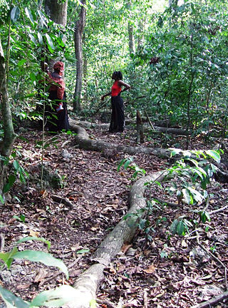
A kaya is a sacred site of the Mijikenda people in the former Coast Province of Kenya. Often located within sacred forests, a kaya is considered to be an intrinsic source of ritual power and the origin of cultural identity; it is also a place of prayer for members of the Mijikenda ethnic group. The settlement, ritual centre, and fortified enclosure associated with the forest are also part of the kaya. In the present day, the kaya is also referred to as a traditional organizational unit of the Mijikenda. Eleven of the approximately 60 separate makaya have been grouped together and inscribed as the Sacred Mijikenda Kaya Forests, a UNESCO World Heritage Site.

Fingo is a protective talisman of the Mijikenda people in Coast Province, Kenya. Fingo are believed to attract guardian spirits (djinns). It is commonly buried in the kaya. Kaya elders take care of the fingo, which is said to have come from Shungwaya, the ancestral home of the Mijikenda. Considered to be interesting objet d'art, many fingo are stolen, while others are lost. The Giriama use large stones as fingo while other Mijikenda use a large pot of medicine. The pottery vessel contains not only medicine but also magic charms. It serves to protect the kaya and its inhabitants, one buried at the entrance and exit of each kaya.

Shungwaya is an origin myth of the Mijikenda peoples. Traditions known collectively as the "Shungwaya myth" describe a series of migrations of Bantu peoples dating to the 12th–17th centuries from a region to the north of the Tana River. However according to Rodger F. Morton, coastal traditions recorded prior to 1897 indicate that the Shungwaya tradition entered Mijikenda oral literature only after this date and is therefore of doubtful veracity. These Bantu migrants were held to have been speakers of Sabaki Bantu languages. Other Bantu ethnic groups, smaller in number, are also suggested to have been part of the migration. From Shungwaya, the Mount Kenya Bantu are then proposed to have broke away and migrated from there some time before the Oromo onslaught. Shungwaya appears to have been, in its heyday, a multi-ethnic settlement with extensive trade networks. Between perhaps the 12th and 15th centuries, this settlement was subjected to a full scale invasion of Cushitic speaking Oromo peoples from he Horn of Africa. From the whole corpus of these traditions, it has been argued that Shungwaya comprised a large, multi-ethnic community.

Kaya Mudzi Muvya is a coastal lowland dry deciduous forest in Kilifi County of southern Kenya. It became a World Heritage Site in 2008. A large portion of the forest is an area protected by the Kenya Forest Service under The Forests Act of 2005, and as a national monument under the Antiquities and Monuments Act Cap 215. The forest is sacred to the local Mijikenda people, known as the Rabai. The forest has suffered deprevation over the past hundred years.

References

  1. "2019 Kenya Population and Housing Census Volume IV: Distribution of Population by Socio-Economic Characteristics". Kenya National Bureau of Statistics. Retrieved 24 March 2020.
  2. Gilbert, Erik; Reynolds, Jonathan T. (2008). Africa in World History: From Prehistory to The Present . Pearson Education, Limited. p.  229. ISBN   9780136154389.
  3. Sperling, David Colton (1988). "The growth of Islam among the Mijikenda of the Kenya coast, 1826 - 1933". Strathmore University. p. 29. Retrieved 16 December 2013.
  4. "Canadian fossil park, an Icelandic volcanic island and archipelago in Yemen among sites added to UNESCO World Heritage List". UNESCO. July 7, 2008. Retrieved 16 December 2013.
  5. 1 2 3 4 Spear, Thomas (1978). The Kaya Complex. Kenya Literature Bureau.
  6. Republic of Kenya. NOMINATION DOSSIER FOR INSCRIPTION ON THE WORLD HERITAGE LIST THE SACRED MIJIKENDA KAYA FORESTS. Unesco.org. THE WORLD HERITAGE CONVENTION, Jan. 2008. Web. 17 Oct. 2016. Pg. 51 - Pg. 61
  7. Walsh, Martin. "MIJIKENDA ORIGINS: A REVIEW OF THE EVIDENCE". Transafrican Journal of History. 21.
  8. 1 2 3 Bresnahan, David P. Sacred Spaces, Political Authority, and the Dynamics of Tradition in Mijikenda History. Thesis. 2010. N.p.: n.p., n.d. Print.
  9. Tinga, Kaingu Kalume. "The Presentation and interpretation of ritual sites: The Mijikenda Kaya Case". Museum International. 56.
  10. 1 2 3 4 5 Gearhard, Rebecca; Giles, Linda (2013). Contesting Identities: The Mijikenda and Their Neighbors in Kenyan Coastal Society. Trenton, New Jersey: African World Press.
  11. Cooper, Frederick (1977). Plantation Slavery on the East African coast. Pearson Education.
  12. Morton, Fred (2008). Children of Ham: Freed Slaves and Fugitive Slaves on the Kenya Coast, 1873 to 1907. iUniverse.