Related Research Articles
The Federal Aviation Regulations (FARs) are rules prescribed by the Federal Aviation Administration (FAA) governing all aviation activities in the United States. The FARs comprise Title 14 of the Code of Federal Regulations (CFR). A wide variety of activities are regulated, such as aircraft design and maintenance, typical airline flights, pilot training activities, hot-air ballooning, lighter-than-air aircraft, man-made structure heights, obstruction lighting and marking, model rocket launches, commercial space operations, model aircraft operations, Unmanned Aircraft Systems (UAS) and kite flying. The rules are designed to promote safe aviation, protecting pilots, flight attendants, passengers and the general public from unnecessary risk.
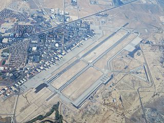
Nellis Air Force Base is a United States Air Force installation in southern Nevada. Nellis hosts air combat exercises such as Exercise Red Flag and close air support exercises such as Green Flag-West flown in "Military Operations Area (MOA) airspace", associated with the nearby Nevada Test and Training Range (NTTR). The base also has the Combined Air and Space Operations Center-Nellis.
Airspace is the portion of the atmosphere controlled by a country above its territory, including its territorial waters or, more generally, any specific three-dimensional portion of the atmosphere. It is not the same as outer space which is the expanse or space outside the Earth and aerospace which is the general term for Earth's atmosphere and the outer space within the planet's vicinity. History:
The Swiss Air Force is the air component of the Swiss Armed Forces, established on 31 July 1914, three days after the outbreak of World War I, as a part of the army and in October 1936 as an independent service.
The world's navigable airspace is divided into three-dimensional segments, each of which is assigned to a specific class. Most nations adhere to the classification specified by the International Civil Aviation Organization (ICAO) and described below, though they might use only some of the classes defined below, and significantly alter the exact rules and requirements. Similarly, individual nations may also designate special use airspace (SUA) with further rules for reasons of national security or safety.
A Notice to Airmen/Notice to Air Men/Notice to Airman/Notice to Air Missions (NOTAM) is a notice filed with an aviation authority to alert aircraft pilots of potential hazards along a flight route or at a location that could affect the flight. NOTAMs are notices or advisories that contain information concerning the establishment, conditions or change in any aeronautical facility, service, procedure or hazard, the timely knowledge of which may be essential to personnel and systems concerned with flight operations. NOTAMs are created and transmitted by government agencies and airport operators under guidelines specified by Annex 15: Aeronautical Information Services of the Convention on International Civil Aviation (CICA). A NOTAM is filed with an aviation authority to alert aircraft pilots of any hazards en route or at a specific location, or Flight Information Region. The authority, in turn, provides a means of disseminating relevant NOTAMs to pilots.

Canadian airspace is the region of airspace above the surface of the Earth within which Canada has jurisdiction. It falls within a region roughly defined as either the Canadian land mass, the Canadian Arctic or the Canadian archipelago, and areas of the high seas. Airspace is managed by Transport Canada and detailed information regarding exact dimensions and classification is available in the Designated Airspace Handbook which is published every fifty-six days by Nav Canada.
Special visual flight rules are a set of aviation regulations under which a pilot may operate an aircraft. It is a special case of operating under visual flight rules (VFR).
A flight information service (FIS) is a form of air traffic service which is available to any aircraft within a flight information region (FIR), as agreed internationally by ICAO.

In air traffic control, an area control center (ACC), also known as a center or en-route center, is a facility responsible for controlling aircraft flying in the airspace of a given flight information region (FIR) at high altitudes between airport approaches and departures. In the US, such a center is referred to as an air route traffic control center (ARTCC).

In aviation, a non-towered airport is an airport without a control tower, or air traffic control (ATC) unit. The vast majority of the world's airports are non-towered. In the United States, there are close to 20,000 non-towered airports compared to approximately 500 airports with control towers. Airports with a control tower without 24/7 ATC service follow non-towered airport procedures when the tower is closed but the airport remains open, for example at night.

A forced landing is a landing by an aircraft made under factors outside the pilot's control, such as the failure of engines, systems, components, or weather which makes continued flight impossible. However, the term also means a landing that has been forced by interception.
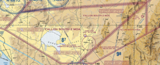
A military operations area (MOA) is an airspace established outside Class A airspace to separate or segregate certain nonhazardous military activities from IFR Traffic and to identify for VFR traffic where these activities are conducted. Similar structures exist under international flight standards. These are designed for routine training or testing maneuvers. Areas near actual combat or other military emergencies are generally designated as restricted airspace. See Temporary Flight Restriction (TFR).

Special use airspace (SUA) is an area designated for operations of a nature such that limitations may be imposed on aircraft not participating in those operations. Often these operations are of a military nature. The designation of SUAs identifies for other users the areas where such activity occurs, provides for segregation of that activity from other users, and allows charting to keep airspace users informed of potential hazards. Most SUAs are depicted on aeronautical charts and FAA maintains a page showing the current status of most SUAs.

Under certain conditions, laser light or other bright lights directed at aircraft can be a hazard. The most likely scenario is when a bright visible laser light causes distraction or temporary flash blindness to a pilot, during a critical phase of flight such as landing or takeoff. It is far less likely, though still possible, that a visible or invisible beam could cause permanent harm to a pilot's eyes. Although laser weapons are under development by armed forces, these are so specialized, expensive and controlled that it is improbable for non-military lasers to cause structural damage to an aircraft.

A prohibited airspace is an area (volume) of airspace within which flight of aircraft is not allowed, usually due to security concerns. It is one of many types of special use airspace designations and is depicted on aeronautical charts with the letter "P" followed by a serial number. It differs from restricted airspace in that entry is typically forbidden at all times from all aircraft and is not subject to clearance from ATC or the airspace's controlling body.

The United States airspace system's classification scheme is intended to maximize pilot flexibility within acceptable levels of risk appropriate to the type of operation and traffic density within that class of airspace – in particular to provide separation and active control in areas of dense or high-speed flight operations.
Red Flag-Alaska is a realistic, ten-day air combat United States Air Force (USAF) training exercise held up to four times a year. It is held at Eielson Air Force Base and Elmendorf Air Force Base in the State of Alaska. Each Red Flag-Alaska exercise is a multi-service, multi-platform coordinated, combat operations exercise and corresponds to the designed operational capability of participating units. In other words, exercises often involve several units whose military mission may differ significantly from that of other participating units. Red Flag-Alaska planners take those factors into consideration when designing exercises so participants get the maximum training possible without being placed at an unfair advantage during simulated combat scenarios.

The Air Defense Identification Zone of North America is an air defense identification zone (ADIZ) that covers the airspace surrounding the United States and Canada – in which the ready identification, location, and control of civil aircraft over land or water is required in the interest of national security. This ADIZ is jointly administered by the civilian air traffic control authorities and the militaries of both nations, under the auspices of the North American Aerospace Defense Command (NORAD). The Federal Aviation Administration (FAA) handles the requests of international aircraft and Transport Canada handles Canadian requests. Any aircraft flying in these zones without authorization may be identified as a threat and treated as an enemy aircraft, potentially leading to interception by fighter aircraft.

Regulation of unmanned aerial vehicles (UAVs) involves setting safety requirements, outlining regulations for the safe flying of drones, and enforcing action against errant users.
References
- 1 2 Hurley, David J. (1990-08-08). "Advisory Circular - Military Flying Activities" (PDF). Federal Aviation Administration . Archived from the original (PDF) on 2016-12-23. Retrieved 2014-05-01.
| | This military aviation article is a stub. You can help Wikipedia by expanding it. |