Mill Creek (San Juan River tributary)

Last updated
Mill Creek
Mill Creek at Light Plant Road.jpg
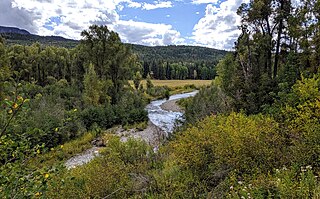
Looking upstream from Light Plant Road
Location
Country United States
State Colorado
Physical characteristics
Source San Juan National Forest
  locationEast of Pagosa Springs, Colorado
  coordinates 37°19′08″N106°49′40″W / 37.31889°N 106.82778°W / 37.31889; -106.82778 [1]
Mouth San Juan River (Colorado River tributary)
  location
South of Pagosa Springs
  coordinates
37°14′35″N107°00′38″W / 37.24306°N 107.01056°W / 37.24306; -107.01056 Coordinates: 37°14′35″N107°00′38″W / 37.24306°N 107.01056°W / 37.24306; -107.01056 [1]
  elevation
6,988 ft (2,130 m)

Mill Creek is a stream in the San Juan National Forest in Archuleta County, Colorado, and a minor left tributary of San Juan River. It flows in a generally southwesterly direction [1] from Mill Creek Canyon, east of Pagosa Springs between Coal Creek and Rio Blanco, to join the San Juan River just sound of Pagosa Springs.

San Juan National Forest national forest in Colorado, United States

The San Juan National Forest is a U.S. National Forest covering over 1,878,846 acres in western Colorado. The forest occupies land in Archuleta, Conejos, Dolores, Hinsdale, La Plata, Mineral, Montezuma, Rio Grande, San Miguel and San Juan Counties. It borders the Uncompahgre National Forest to the north and the Rio Grande National Forest to the east. The forest covers most of the southern portion of the San Juan Mountains west of the Continental Divide. The forest contains two alpine wilderness areas; the Weminuche and South San Juan, as well as the Piedra Area. The Durango and Silverton Narrow Gauge Railroad passes through the National Forest.

Archuleta County, Colorado U.S. county in Colorado

Archuleta County is one of the 64 counties in the U.S. state of Colorado. As of the 2010 census, the population was 12,084. The county seat and the only incorporated municipality in the county is Pagosa Springs.

San Juan River (Colorado River tributary) significant tributary of the Colorado River in the southwestern United States

The San Juan River is a major tributary of the Colorado River in the Southwestern United States, providing the chief drainage for the Four Corners region of Colorado, New Mexico, Utah and Arizona. Originating as snowmelt in the San Juan Mountains of Colorado, it flows 383 miles (616 km) through the deserts of northern New Mexico and southeastern Utah to join the Colorado River at Glen Canyon. The river drains a high, arid region of the Colorado Plateau and along its length it is often the only significant source of fresh water for many miles. The San Juan is also one of the muddiest rivers in North America, carrying an average of 25 million US tons of silt and sediment each year.

Mill Creek Archuleta County CO pano.jpg
Panoramic view of Mill Creek from Light Plant Road, just above its confluence with the San Juan
View toward the confluence with the San Juan Mill Creek Archuleta County CO.jpg
View toward the confluence with the San Juan

See also

Related Research Articles

Pagosa Springs, Colorado Town in State of Colorado, United States

Pagosa Springs is a municipality that is the county seat of, and the only incorporated municipality in, Archuleta County, Colorado, United States. The population was 1,727 at the 2010 census. Approximately 65 percent of the land in Archuleta County is either San Juan National Forest, Weminuche and South San Juan Wilderness areas, or Southern Ute Indian land.

Wolf Creek Pass mountain pass in Colorado

Wolf Creek Pass is a high mountain pass on the Continental Divide, in the San Juan Mountains of Colorado. It is the route through which U.S. Highway 160 passes from the San Luis Valley into southwest Colorado on its way to New Mexico and Arizona. The pass is notable as inspiration of a C. W. McCall song. The pass is significantly steep on either side and can be dangerous in winter. There are two runaway truck ramps on the westbound side for truckers that lose control of their brakes.

Conejos River river in the United States of America

The Conejos River is a tributary of the Rio Grande, approximately 92.5 miles (148.9 km) long, in south-central Colorado in the United States. It drains a scenic area of the eastern San Juan Mountains west of the San Luis Valley.

Uncompahgre Peak mountain

Uncompahgre Peak is the sixth highest summit of the Rocky Mountains of North America and the U.S. state of Colorado. The prominent 14,321-foot (4365.0 m) fourteener is the highest summit of the San Juan Mountains and the highest point in the drainage basin of the Colorado River and the Gulf of California. It is located in the Uncompahgre Wilderness in the northern San Juans, in northern Hinsdale County approximately 7 miles (11 km) west of the town of Lake City.

La Garita Caldera supervolcanic caldera

La Garita Caldera is a large supervolcanic caldera in the San Juan volcanic field in the San Juan Mountains near the town of Creede in southwestern Colorado, United States. It is west of La Garita, Colorado. The eruption that created the La Garita Caldera is among the largest known volcanic eruptions in Earth's history, as well as being one of the most powerful known supervolcanic events.

Wolf Creek ski area

Wolf Creek Ski Area (WCSA) is a ski area in southwest Colorado, located on the Wolf Creek Pass between Pagosa Springs and South Fork. It is best known for receiving more average annual snowfall than any other resort in Colorado, at about 480 inches per year.

Colorado River cutthroat trout subspecies of fish

The Colorado River cutthroat trout is a subspecies of cutthroat trout native only to the Green and Colorado River basins, which are west of the Continental Divide. Cutthroat trout found in other river basins belong to other subspecies.

South San Juan Wilderness

The South San Juan Wilderness is a U.S. Wilderness Area located in the San Juan National Forest, east of Pagosa Springs, in southern Colorado.

Piedra, Colorado Census-designated place in Colorado, United States

Piedra is a census-designated place (CDP) in Hinsdale County, Colorado, United States. The population as of the 2010 census was 28.

Rio Blanco (Colorado) river in the United States of America

Rio Blanco is a stream that is tributary of the San Juan River in southern Colorado, United States. The stream originates in the San Juan Mountains and flows for 30 miles (48 km) through the San Juan National Forest and private lands to its confluence with the San Juan River in Archuleta County, Colorado. Colorado classifies the Rio Blanco as an Aquatic Life Coldwater Class 1/Recreation Class 1 waterway supporting water supply and agricultural uses. The river also features native cutthroat trout and introduced rainbow trout fishing.

Horse Mountain mountain in United States of America

Horse Mountain is a prominent mountain summit in the San Juan Mountains range of the Rocky Mountains of North America. The 9,952-foot (3,033 m) peak is located in San Juan National Forest, 15.8 miles (25.5 km) west by north of the Town of Pagosa Springs in Archuleta County, Colorado, United States.

Treasure Falls

Treasure Falls is a waterfall in the San Juan Mountains, within Mineral County, Colorado. It is located in the San Juan National Forest, off U.S. Highway 160, about 15 miles (24 km) northeast of Pagosa Springs.

West Fork Complex

The West Fork Complex was a complex of wildfires near Wolf Creek Pass in southern Colorado. The first fire, the West Fork fire, was started by lightning at about 1 PM on June 5, 2013. All three fires were started by lightning. As the fire moved into heavy dead timber in early June thousands of firefighters struggled to prevent movement of the fires into populated areas.

References

  1. 1 2 3 "Mill Creek". Geographic Names Information System . United States Geological Survey. 1978-10-13. Retrieved 2019-09-29.