Milton Creek Country Park

Last updated

Milton Creek Country Park
Church Marshes Country Park - work in progress - geograph.org.uk - 710844.jpg
Footpath under construction
Kent UK location map.svg
Red pog.svg
Milton Creek Country Park shown within Kent
OS grid TQ 912 653
Coordinates 51°21′18″N0°44′42″E / 51.355°N 0.745°E / 51.355; 0.745
Area128 acres (52 ha)
Created2011 (2011) (Was Church Marshes in 2001)
Operated by Swale Borough Council,
Open7 days a week, dawn until dusk
Statuscomplete
Website Milton Creek Country Park

Milton Creek Country Park is situated in 128 acres between Milton Regis and Kemsley , on the west bank of Milton Creek in Sittingbourne, Kent, England. This site was once called Church Marshes Country Park. [1]

Contents

Geography

Church Marshes is at the base of Kemsley Down (hills near Kemsley), on the banks of Milton Creek where it flows into the Swale. It is partly due to these two navigable waters which link directly to the River Thames and its estuary across the English Channel to Europe, that marshes formed and gave nearby locations their rich history. The marshes are named after Holy Trinity Church in Milton Regis. (See Milton Regis for more details on the church).

History

The site of the country park has been used since early times and archaeological evidence shows that Saxon and Roman Britain settlements were present in the vicinity. Holy Trinity Church and Castle Rough [2] are the last remaining local historical features.

In the Victorian era the region was used for barge-building and gravel extraction for brick-making. Barges transported the bricks to London and returned with London’s domestic waste to be burnt or buried at the site. [3] Churchfield Wharf was also formerly the site of a ship breaking company. [4]

The Romani people formerly had a site in the Milton Creek area. [5] [6] It was a former brick and gravel pit; the area became a landfill site, which closed in 1973. [7] After the site closed, it needed remedial work due to the Environmental Protection Act 1990, carried out jointly by Swale Council, Groundwork Kent & Medway and Rural Arising Ltd (a firm of engineers and ecologists, who specialise in urban regeneration of landfill sites and other similar industrial sites). [8] Rural Arising Ltd, together with Groundwork Kent & Medway and Sittingbourne Community College also provided training and education to a group of 15- and 16-year-olds.

The main purpose of the country park was to create a green space which met the needs of a predominantly urban population within a countryside setting rich in biodiversity. Groundwork started work in 2001. The project took place over eight phases, including dealing with the contamination and landfill gases, wildlife conservation works, planting of trees, scrubs, pond-side and meadow plants, construction of paths, picnic/play areas, etc. [1]

When Swale Council started planning for the Sittingbourne Northern Relief Road (SNRR) [9] which passes on the northern boundary of the park near Church Wharf on Milton Creek, it decided in 2008 to increase the size of the park to incorporate the Saxon Shore Way (running along the Milton Creek), which links Sittingbourne town centre to the country park, which was renamed in 2009 as Milton Creek Country Park. [10] The Saxon Shore path passes through a sequence of viewpoints, one at each of the historic wharves along the creek, including Grandsdens Wharf, Eastwoods’ Wharf and Church Wharf. The aim of the project was to provide a ‘green heart’ for Sittingbourne. [11]

Creating the park cost £2.25 million – £2 million of which was Thames Gateway funding awarded via the Homes and Communities Agency. The rest was provided by Kent County Council.

Groundwork established a Friends of Church Marshes voluntary group, which meets quarterly [12] and a summer fete was held in 2007. [5] They also helped construction of various paths within the park. [13]

Various artists have been commissioned to create works to promote the country park. [14]

The official opening of the country park was on 4 June 2012. [15]

Facilities

Milton Creek Country Park Play Area Milton Creek Country Park Play Area.JPG
Milton Creek Country Park Play Area

As part of the Thames Gateway Parklands development, new footpath surfaces and various artworks have been placed along the Milton Creek on the Saxon Shore Way from Gas Road to the country park. [16]

A new car park on Saffron Way was finished in 2012. [10]

There is a large community events space and Churchfield Wharf, located next to the new road bridge, provides a 'mini-destination' next to the creek. [10]

The 'sandscape' area has been designed for toddlers and has slides, a bridge and a large seat for parents. The 'marshland' space, has been primarily designed for older children, it features a 7m space-net, reminiscent of the rigging on barges that travelled on the creek. The hill is a place where teenagers can sit. [17]

The large lake within the park is controlled by Kemsley Community Angling Preservation Society (KCAPS) which is a community run club for members and the public. . [18] [19]

Wildlife

Working with Kent Wildlife Trust, various groups have created ecological habitats for several rare creatures, including great crested newt and the shrill carder bee. Other wildlife found within the park includes the common lizard, Colias (clouded yellow butterfly), glow worms and slowworms. [20]

The land at the northern end of the creek lies within the Swale Estuary Special Protection Area (SPA), Site of Special Scientific Interest (SSSI) and Ramsar Site. [10]

A small orchard, which was ‘lost’ is being restored as a feature of the park. [10]

Some trees have already been planted in the woodland area – funded by the Forestry Commission. [17]

Known birds visiting the site include the redshank, black-tailed godwit, teal and grey plover. [20]

Park access

The park can be accessed in various ways, for example via Kemsley Recreation Ground, Grovehurst Road, Newman Drive (as it turns into Recreation Way), Walsby Drive (in the housing estate), Miller Close (in the housing estate), Green Porch Close (by Holy Trinity Church), Gas Road (by CPM - formerly Milton Pipes) and via the Northern Relief Road. [11]

Also, National Cycle Route 1 passes the country park via the B2005, Saffron Way. The Swale Heritage Trail (another long distance local trail) now ends at the park via the Northern Relief Road. [21]

Related Research Articles

<span class="mw-page-title-main">Queenborough</span> Town on the Isle of Sheppey in the Swale borough of Kent, South East England

Queenborough is a town on the Isle of Sheppey in the Swale borough of Kent in South East England.

<span class="mw-page-title-main">Borough of Swale</span> Non-metropolitan district in England

Swale is a local government district with borough status in Kent, England and is bounded by Medway to the west, Canterbury to the east, Ashford to the south and Maidstone to the south west. Its council is based in Sittingbourne. The district is named after the narrow channel called The Swale, that separates the mainland of Kent from the Isle of Sheppey, and which occupies the central part of the district.

<span class="mw-page-title-main">Faversham</span> Market town in England

Faversham is a market town in Kent, England, 8 miles (13 km) from Sittingbourne, 48 miles (77 km) from London and 10 miles (16 km) from Canterbury, next to the Swale, a strip of sea separating mainland Kent from the Isle of Sheppey in the Thames Estuary. It is close to the A2, which follows an ancient British trackway which was used by the Romans and the Anglo-Saxons, and known as Watling Street. The name is of Old English origin, meaning "the metal-worker's village".

<span class="mw-page-title-main">Sittingbourne</span> Town in Kent, England

Sittingbourne is an industrial town in Kent, south-east England, 17 miles (27 km) from Canterbury and 45 miles (72 km) from London, beside the Roman Watling Street, an ancient British trackway used by the Romans and the Anglo-Saxons and next to the Swale, a strip of sea separating mainland Kent from the Isle of Sheppey. The town became prominent after the death of Thomas Becket in 1170, since it provided a convenient resting point on the road from London to Canterbury and Dover.

<span class="mw-page-title-main">North Kent Marshes</span>

The North Kent Marshes are in the far north of the county of Kent spanning dry and wet south banks and inlets of the Thames Estuary in south-east England. The marshes are one of 22 Environmentally Sensitive Areas recognised by the UK's Department for Environment, Food and Rural Affairs (DEFRA). They are in the Thames Gateway regional planning area. They include the 5,289-hectare (20.4 sq mi) South Thames Estuary and Marshes biological SSSI.

<span class="mw-page-title-main">Sittingbourne and Kemsley Light Railway</span>

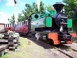
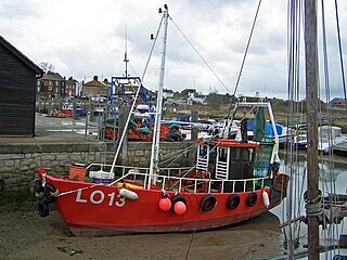
The Sittingbourne and Kemsley Light Railway in Kent is a 2 ft 6 in narrow gauge heritage railway that operates from Sittingbourne to the banks of The Swale.

<span class="mw-page-title-main">Sittingbourne and Sheppey (UK Parliament constituency)</span>

Sittingbourne and Sheppey is a constituency in Kent represented in the House of Commons of the UK Parliament since 2010 by Gordon Henderson, a Conservative.

<span class="mw-page-title-main">Bapchild</span> Village in Kent, England

Bapchild is a village and civil parish in the Swale district of Kent, England, about two miles inside of Sittingbourne. It lies on the old Roman road now the A2, and according to the 2001 census, the parish had a population of 1,068, including Tonge, increasing to 1,141 at the 2011 Census.

<span class="mw-page-title-main">A249 road</span> A road in Kent, England, UK

The A249 is a road in Kent, England, running from Maidstone to Sheerness on the Isle of Sheppey. It mainly functions as a link between the M2 and M20 motorways, and for goods vehicle traffic to the port at Sheerness.

<span class="mw-page-title-main">Saxon Shore Way</span> Long-distance footpath in England

The Saxon Shore Way is a long-distance footpath in England. It starts at Gravesend, Kent, and traces the coast of South-East England as it was in Roman times as far as Hastings, East Sussex, 163 miles (262 km) in total. This means that around Romney Marsh the route runs significantly inland from the modern coastline.

<span class="mw-page-title-main">Lower Halstow</span> Human settlement in England

Lower Halstow is a village and civil parish in the Swale district of Kent, England. The village is northwest of Sittingbourne on the banks of the Medway Estuary. It lies north of Newington on the A2 Roman road.

<span class="mw-page-title-main">Newington, Swale</span> Human settlement in England

Newington is a village and civil parish in the borough of Swale in Kent, England. The parish is located beside the A2 road between Rainham to the west and Sittingbourne to the east. The population of the parish in 2011 was 2,551.

<span class="mw-page-title-main">Faversham (UK Parliament constituency)</span>

Faversham was a parliamentary constituency centred on the town of Faversham in Kent which returned one Member of Parliament (MP) to the House of Commons of the Parliament of the United Kingdom.

<span class="mw-page-title-main">Bowaters Paper Railway</span>

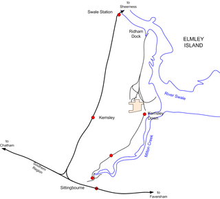
The Bowaters Paper Railway was a 2 ft 6 in narrow gauge industrial railway running from Sittingbourne to Ridham Dock on The Swale in the county of Kent. It had the distinction of being the last steam-operated industrial narrow gauge railway in Britain when it closed in 1969. Part of the system still operates as the Sittingbourne & Kemsley Light Railway.

<span class="mw-page-title-main">Milton Regis</span> Human settlement in England

Milton Regis is a village in the district of Swale in Kent, England. Former names include Milton-next-Sittingbourne, Milton Royal, Middleton, Midletun and Middletune. It has a population of about 5,000. Today it is a suburb of Sittingbourne, although this has not always been the case, with Milton Regis having an older and richer history. Until around 1800, Sittingbourne was a smaller hamlet and under the control of the Manor of Milton Regis.

<span class="mw-page-title-main">Murston</span> Human settlement in England

Murston is a suburb of Sittingbourne in Kent, England. It is about 1 mile north-east of central Sittingbourne, on the east bank of the Milton Creek.

Kemsley is a suburb of Sittingbourne in Kent, England.

<span class="mw-page-title-main">Riverside Country Park</span>

Riverside Country Park is a large coastal public park, situated alongside the River Medway estuary between Gillingham and Rainham. The park covers about 100 hectares - approximately 247 acres (1.00 km2). There are a variety of natural habitats within the park, including mudflats and salt marsh, ponds and reed-beds, grassland and scrub, which provide a haven for wildlife.

<span class="mw-page-title-main">Kemsley Paper Mill</span>

Kemsley Paper Mill is a paper mill located in the village of Kemsley near Sittingbourne in the English county of Kent.

References

  1. 1 2 "Church Marshes Country Park - Groundwork Kent & Medway". Archived from the original on 4 May 2011. Retrieved 22 June 2011.
  2. Davis, Philip. "Castle rough Sittingbourne". Gatehouse. Retrieved 22 August 2015.
  3. "Church Marshes - Groundwork Kent & Medway". Archived from the original on 24 April 2012. Retrieved 16 April 2012.
  4. "Archived copy". Archived from the original on 16 April 2012. Retrieved 16 April 2012.{{cite web}}: CS1 maint: archived copy as title (link)
  5. 1 2 http://www.swale.gov.uk/assets/Regeneration-Projects/Milton-Creek/Milton-Creek-Community-Engagement-Strategy.pdf [ bare URL PDF ]
  6. "BBC - Kent - Romany Roots - Young Romany Gypsies - Sarah".
  7. http://www.ruralarisings.co.uk/roclf.swf?ms=1229904000057%5B%5D
  8. "Rural-Arisings". Archived from the original on 25 April 2012. Retrieved 16 April 2012.
  9. "Sittingbourne Northern Relief Road". Archived from the original on 22 August 2011. Retrieved 23 June 2011.
  10. 1 2 3 4 5 http://www.swale.gov.uk/assets/Regeneration-Projects/Sheerness-Gateway/Milton-Creek-Monitoring-and-Evaluation-Report-FINAL-REPORT.pdf [ bare URL PDF ]
  11. 1 2 "Woodlands and Country Parks".
  12. http://www.01795599975.talktalk.net/Friends.html
  13. "Archived copy" (PDF). Archived from the original (PDF) on 1 October 2011. Retrieved 23 June 2011.{{cite web}}: CS1 maint: archived copy as title (link)
  14. "Heather and Ivan Morison: Sleepers Awake, Milton Creek Country Park, Sittingbourne, Kent: review". The Daily Telegraph . Archived from the original on 3 February 2023.
  15. http://www.swalecvs.org.uk/documents/NewsletterApril2012.pdf%5B%5D
  16. "Milton Creek". Archived from the original on 10 July 2012. Retrieved 26 July 2011.
  17. 1 2 "SET in 128 acres, Milton Creek Country Park stretches from the shore of the creek, past Asda and Milton Regis's Holy Trinity Church, to the paper mill and fishing lakes in Kemsley. | This is Kent". www.thisiskent.co.uk. Archived from the original on 21 April 2013. Retrieved 2 February 2022.
  18. "Fishing platform at Church Marshes Country Park destroyed by fire". Archived from the original on 30 September 2012. Retrieved 22 June 2011.
  19. "KCAPS Fishing Club".
  20. 1 2 "Wildlife".
  21. "Archived copy" (PDF). Archived from the original (PDF) on 25 April 2012. Retrieved 14 October 2011.{{cite web}}: CS1 maint: archived copy as title (link)