
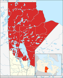
Manitoba is a province at the longitudinal centre of Canada. It is often considered one of the three prairie provinces and is Canada's fifth-most populous province with its estimated 1.3 million people. Manitoba covers 649,950 square kilometres (250,900 sq mi) with a widely varied landscape, stretching from the northern oceanic coastline to the southern border with the United States. The province is bordered by the provinces of Ontario to the east and Saskatchewan to the west, the territories of Nunavut to the north, and Northwest Territories to the northwest, and the U.S. states of North Dakota and Minnesota to the south.

The Red River is a North American river. Originating at the confluence of the Bois de Sioux and Otter Tail rivers between the U.S. states of Minnesota and North Dakota, it flows northward through the Red River Valley, forming most of the border of Minnesota and North Dakota and continuing into Manitoba. It empties into Lake Winnipeg, whose waters join the Nelson River and ultimately flow into Hudson Bay.
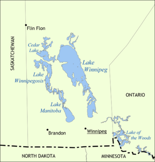
Lake Winnipeg is a very large, but relatively shallow 24,514-square-kilometre (9,465 sq mi) lake in North America, in the province of Manitoba, Canada. Its southern end is about 55 kilometres (34 mi) north of the city of Winnipeg. It is the largest lake within southern Canada's borders, and is part of the most undeveloped large watershed of southern Canada.
Lake Winnipegosis is a large (5,370 km²) lake in central North America, in Manitoba, Canada, some 300 km northwest of Winnipeg. It is Canada's eleventh-largest lake. An alternate spelling, once common but now rare, is Lake Winipigoos or simply 'Lake Winipigis'.

The Nelson River is a river of north-central North America, in the Canadian province of Manitoba. The river drains Lake Winnipeg and runs 644 kilometres (400 mi) before it ends in Hudson Bay. Its full length is 2,575 kilometres (1,600 mi), it has mean discharge of 2,370 cubic metres per second (84,000 cu ft/s), and has a drainage basin of 1,072,300 square kilometres (414,000 sq mi), of which 180,000 square kilometres (69,000 sq mi) is in the United States.

The Assiniboine River is a 1,070-kilometre (660 mi) river that runs through the prairies of Western Canada in Saskatchewan and Manitoba. It is a tributary of the Red River. The Assiniboine is a typical meandering river with a single main channel embanked within a flat, shallow valley in some places and a steep valley in others. Its main tributaries are the Qu'Appelle, Souris and Whitesand Rivers. For early history and exploration see Assiniboine River fur trade.

The Churchill River is a major river in Alberta, Saskatchewan and Manitoba, Canada. From the head of the Churchill Lake it is 1,609 kilometres (1,000 mi) long. It was named after John Churchill, 1st Duke of Marlborough and governor of the Hudson's Bay Company from 1685 to 1691.
Northern Manitoba is the most northerly region of the Canadian province of Manitoba, added to the province during the last major expansion of its boundaries in 1912. Forestry, mining and hydro-electric development are significant economic drivers with long-term consequences to the environment in the region.
Riding Mountain National Park is a national park in Manitoba, Canada. The park sits atop the Manitoba Escarpment. Consisting of a protected area 2,969 km2 (1,146 sq mi), the forested parkland stands in sharp contrast to the surrounding prairie farmland. It was designated a national park because it protects three different ecosystems that converge in the area; grasslands, upland boreal and eastern deciduous forests. It is most easily reached by Highway 10 which passes through the park. The south entrance is at the townsite of Wasagaming, which is the only commercial centre within the park boundaries.

Morris is a small town in the Pembina Valley region of Manitoba, Canada, located 51 km south of Winnipeg and 42 km north of Emerson. Morris is home to 1,885 people (2016). Named after Alexander Morris, the second Lieutenant Governor of Manitoba.
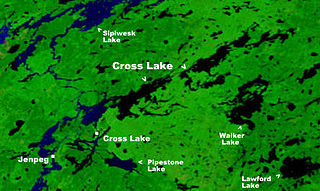
Cross Lake is the name of two closely related, adjoining but independent communities in the Canadian province of Manitoba. One of the Cross Lakes is the Cross Lake Indian Reserve of the Cross Lake First Nation where the main urban area is called Cross Lake. The other Cross Lake is on nearby provincial Crown land. The communities are located about 520 kilometres by air north of Winnipeg, and 120 kilometres by air south of Thompson. They are situated on the shores of the Nelson River where the river enters Cross Lake. An all-weather road, PR 374, connects the communities to PR 373 via the Kichi Sipi Bridge.

Grand Rapids is a town in Manitoba, Canada located on the northwestern shore of Lake Winnipeg where the Saskatchewan River enters the lake. As the name implies, the river had a significant drop at this point. In modern days, a large hydro electric generating plant has been built. Cedar Lake, just a short distance up the river provides a natural water storage for this plant. PTH 6, the primary roadway in the region, crosses the Saskatchewan River at the Grand Rapids bridge.

The geography of Manitoba addresses the easternmost of the three prairie Canadian provinces, located in the longitudinal center of Canada. Manitoba borders on Saskatchewan to the west, Ontario to the east, Nunavut to the north, and the American states of North Dakota and Minnesota to the south. Although the border with Saskatchewan appears straight on large-scale maps, it actually has many right-angle corners that give the appearance of a slanted line. In elevation, Manitoba ranges from sea level on Hudson Bay to 2727 ft (831 m) on top of Baldy Mountain. The northern sixty percent of the province is on the Canadian Shield. The northernmost regions of Manitoba lie permafrost, and a section of tundra bordering Hudson Bay.
Cross Lake is a large lake in Manitoba on the Nelson River north of Lake Winnipeg. It is long and narrow and extends 102 km (63 mi) east-northeast.
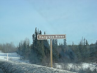
The Hargrave River is a river in the Hudson Bay drainage basin in Northern Manitoba, Canada. It flows in a southeasterly direction from its source at Hargrave Lake to Hill Lake on the Minago River which flows into Cross Lake on the Nelson River.
The Old Dawson Trail is the remnant of the first all-Canadian route that linked the Great Lakes with the Canadian prairies. It was a water and land route that began at Port Arthur, Ontario and ended at St. Boniface. The land portions of the trail are usually referred to as Dawson Road.

Moose Lake is a lake located near the Saskatchewan River delta in Manitoba, Canada. It is separated into two irregularly shaped lobes, North Moose Lake and South Moose Lake, by the Moose Lake Narrows Control Structure, which was built in 1964. South Moose Lake drains south into Cedar Lake via Moose Creek; these two lakes form the reservoir of the Grand Rapids Generating Station, and the sluice gates at Moose Lake Narrows helps regulate their water levels. The lake as a whole lies at an elevation of 255 metres (837 ft) and covers 1,367 square kilometres (528 sq mi). The community of Moose Lake is located on the south shore of the lake.

Black Duck Creek is a stream in the Northern Region of Manitoba, Canada. It is in the Hudson Bay drainage basin and is a right tributary of the Minago River.


