| Minard [1] | |
|---|---|
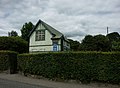
 Minard and Loch Fyne Minard cottages mid-way between Inveraray and Lochgilphead on the shore of Loch Fyne. | |
 Minard [4] Location within Argyll and Bute | |
| OS grid reference | NR979964 |
| Civil parish |
|
| Council area | |
| Lieutenancy area | |
| Country | Scotland |
| Sovereign state | United Kingdom |
| Post town | Inveraray |
| Postcode district | PA32 |
| Dialling code | 01546 |
| UK Parliament | |
| Scottish Parliament | |
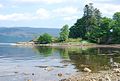
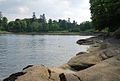
Minard is a rural village on the western shore of Loch Fyne, situated between Inveraray and Lochgilphead. Minard is 13+1⁄2 miles (21.7 km) southwest of Inveraray, and is located at the northwestern corner of Achagoyle Bay. Minard is a linear village with lochside bungalows which has seen extensive building. Along the A83 road to the south is a school, church, village hall and several older cottages which break up the linear aspect. [5]