The Isle of Sheppey is an island off the northern coast of Kent, England, neighbouring the Thames Estuary, centred 42 miles (68 km) from central London. It has an area of 36 square miles (93 km2). The island forms part of the local government district of Swale. Sheppey is derived from Old English Sceapig, meaning "Sheep Island".
Queenborough is a town on the Isle of Sheppey in the Swale borough of Kent in South East England.

Swale is a local government district with borough status in Kent, England. The council is based in Sittingbourne, the borough's largest town. The borough also contains the towns of Faversham, Queenborough and Sheerness, along with numerous villages and surrounding rural areas. It includes the Isle of Sheppey and is named after The Swale, the narrow channel which separates Sheppey from the mainland part of the borough. Some southern parts of the borough lie within the Kent Downs, a designated Area of Outstanding Natural Beauty.

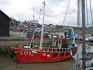
Sheerness is a port town and civil parish beside the mouth of the River Medway on the north-west corner of the Isle of Sheppey in north Kent, England. With a population of 11,938, it is the second largest town on the island after the nearby town of Minster which has a population of 21,319.
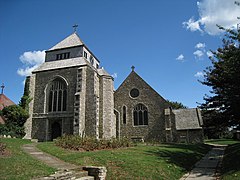
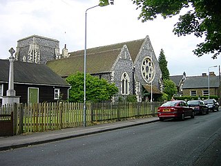
Minster is a town on the north coast of the Isle of Sheppey in Kent, south-east England. It is in the Swale administrative district, and within that, in the parish of Minster-on-Sea. According to the 2021 Census, the population of Minster was 17,389.

Iwerne Minster is a village and civil parish in Dorset, England. It lies on the edge of the Blackmore Vale, approximately midway between the towns of Shaftesbury and Blandford Forum. The A350 main road between those towns passes through the edge of the village, just to the west. In the 2011 Census the civil parish had a population of 978.

The Swale is a tidal channel of the Thames estuary that separates the Isle of Sheppey from the rest of Kent. On its banks is a 6,509.4-hectare (16,085-acre) biological Site of Special Scientific Interest which stretches from Sittingbourne to Whitstable in Kent. It is also a Ramsar internationally important wetland site and a Special Protection Area under the European Union Directive on the Conservation of Wild Birds. Parts of it are a Nature Conservation Review site, Grade I, National Nature Reserves, a Kent Wildlife Trust nature reserve and a Local Nature Reserve.

Sittingbourne and Sheppey is a constituency in Kent represented in the House of Commons of the UK Parliament since 2010 by Gordon Henderson, a Conservative.
Queenborough-in-Sheppey was a municipal borough in Kent, England from 1968 to 1974. It was created by a merger of the Municipal Borough of Queenborough with Sheerness Urban District and Sheppey Rural District, and occupied the entire Isle of Sheppey. It incorporated the following parishes:

Bolton-on-Swale is a village and civil parish in the Richmondshire district of North Yorkshire, England. In 2015, North Yorkshire County Council estimated the population of the civil parish to be 70.
Ellerton-on-Swale or Ellerton is a small village and civil parish about a mile east of Catterick in the Richmondshire district of North Yorkshire, England. In 2015, North Yorkshire County Council estimated the population of the parish at 110.

Minster Lovell is a village and civil parish on the River Windrush about 2+1⁄2 miles (4 km) west of Witney in Oxfordshire. The 2011 Census recorded the parish's population as 1,409. Minster Lovell village has three parts: Old Minster, Little Minster and New Minster. Old Minster includes the parish church, Minster Lovell Hall and the Old Swan Inn and Minster Mill Hotel. A large part of New Minster is the Charterville Allotments, which were founded by the Chartists in 1846–50.

Milton Regis is a village in the district of Swale in Kent, England. Former names include Milton-next-Sittingbourne, Milton Royal, Middleton, Midletun and Middletune. It has a population of about 5,000. Today it is a suburb of Sittingbourne, although this has not always been the case. Until around 1800, Sittingbourne was a small hamlet and under the control of the Manor of Milton Regis.

Leysdown-on-Sea is a village on the east coast of the Isle of Sheppey, in the borough of Swale in Kent, England. In 2020 it had an estimated population of 936. The civil parish is Leysdown and includes the settlements of Bay View, Shellness and Harty. In 2011 it had a population of 1,256.
Goodnestone is a village and former civil parish, now in the parish of Graveney with Goodnestone, in the Swale district of Kent, England. The village is mainly on the road 'Head Hill Road' towards Graveney. In 1961 the parish had a population of 58.

Elmley is the local name for the Isle of Elmley, in the civil parish of Minster-on-Sea, part of the Isle of Sheppey in the Swale district, in the county of Kent, England. It was also the name of a very late 19th century industrial village on the isle. Edward Hasted describes, in 1798, the isle as two-eighths of the Isle of Sheppey estimated as 11 miles by 8 miles. Its present national nature reserve covers more than the easily traceable area of the former isle by extending to the east, over Windmill Creek, one of two Sheppey inlets, former internal tidal channels.
Murston is a suburb of Sittingbourne, in the Swale district, in the county of Kent, England. It is about 1 mile north-east of central Sittingbourne, on the east bank of the Milton Creek.

Halfway Houses is a village on the Isle of Sheppey in the Swale borough of Kent in England. It derives its name from the pub in the village centre, with the same name, which was so named because it is halfway between Minster and Sheerness, before the coastal road was built along the north coast connecting Minster and Sheerness. It is bordered to the west by the town of Queenborough and the village of Minster-on-Sea, and to the east by the town of Minster. It is one mile south of the town of Sheerness. It is in the Queenborough and Halfway ward of Swale Borough Council.
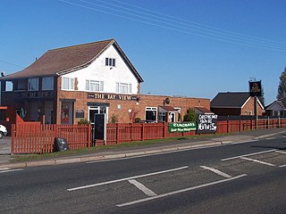
Bay View is a hamlet in the civil parish of Leysdown, on the east side of the Isle of Sheppey in the borough of Swale in Kent, England. In 2020 it had an estimated population of 699.