This article needs additional citations for verification .(August 2016) |
Mintlaw Trestle | |
|---|---|
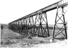 The Mintlaw Trestle | |
| Coordinates | 52°12′28″N113°54′52″W / 52.20778°N 113.91444°W |
| Carries | Railway |
| Crosses | Red Deer River |
| Locale | Mintlaw, Alberta |
| Official name | Mintlaw Trestle |
| Characteristics | |
| Total length | 644 m (2,112 ft) |
| Height | 34 m (110 ft) |
| Longest span | 46 m (150 ft) truss span |
| History | |
| Constructed by | Alberta Central Railway |
| Opened | 1912 |
| Closed | 1983 |
| Location | |
 Interactive map of Mintlaw Trestle | |
The Mintlaw Trestle is an abandoned steel and wooden railway trestle that was built over the Red Deer River by the Alberta Central Railway near Mintlaw, Alberta, in 1912. The last train to cross the bridge was in 1981, and the line and bridge was abandoned in 1983. [1] The bridge is the second longest Canadian Pacific Railway bridge of its kind in Alberta. It is the longest and the highest bridge in Central Alberta. It is west of Tuttle, northwest of Penhold, southwest of Red Deer, northwest of Red Deer Airport, and near the intersection of the C & E Trail and McKenzie Road.