Mississauga City Centre

Last updated
Mississauga City Centre
Burnhamthorpe Rd W, Mississauga - panoramio (1).jpg
Mississauga skyline in 2016
Mississauga City Centre.png
Location of Mississauga City Centre
Coordinates: 43°33′31″N79°38′38″W / 43.5587°N 79.6440°W / 43.5587; -79.6440
CountryCanada
ProvinceOntario
Regional municipalityPeel
City Mississauga

Mississauga City Centre is the downtown of Mississauga, Ontario, Canada. The downtown district is located generally at the intersection of Hurontario Street and Burnhamthorpe Road, centred around Square One Shopping Centre.

Contents

Design and layout

Highrise corridor developing along Confederation Parkway JZ-CPWS121820A-MCC.jpg
Highrise corridor developing along Confederation Parkway

Mississauga is a suburban city, restructured from the predominantly rural Toronto Township, and as a result the core is a modern and fully planned greenfield development, rather than a traditional city downtown which grew organically over a long period of time. As such, its boundaries are sharp and there is no transitional inner city between it and the surrounding suburban areas, some of which are older than the city centre itself. In addition, despite Mississauga being located on Lake Ontario, the city centre is not located on or near the waterfront (as is typically the case for cities situated by water), but is located 6 km (3.7 mi) inland.[ citation needed ]

Originally there was an octagonal ring road encircling Square One Shopping Centre, [1] but later changes to the street pattern as development progressed resulted in parts of it being incorporated into the present City Centre Drive and Duke of York Boulevard or being replaced by Square One Drive. [2]

The early developments in the city centre were mostly office buildings set in the middle of parking lots or condominiums constructed in tower in the park settings, as was the typical before the new urbanism principle was applied in the city centre planning area. Two of these office developments (including Mississauga's second Civic Centre) have since been demolished and have been or are being replaced with new projects. [3] [4]

History

Mississauga Civic Centre, completed in 1987 Mississauga City Hall 2021.jpg
Mississauga Civic Centre, completed in 1987

The intersection of Hurontario Street and Burnhamthorpe Road was once the site of a rural hamlet named Payne's Corners. [5] Prior to 1973, the area was predominantly agricultural. In the 1950s, developer Bruce McLaughlin began buying up farms in the area as he envisioned the-then mostly rural Toronto Township, as Mississauga was then known, becoming a future major city (at the time, suburban growth was already spilling over from Metropolitan Toronto) with a new urban core. To get his envisioned core started, he proposed building Square One in 1969. The new core was given an additional boost that year after a fire badly damaged the newly incorporated Town of Mississauga's municipal offices in the nearby community of Cooksville, prompting the municipality to move its offices (a move that was already being contemplated) to a new building constructed on a plot of land in the area exchanged with McLaughlin for the old Cooksville property. [6] [7]

In 1973, Square One opened, [7] and it provided the catalyst for the development of the new city centre. Mississauga's first mayor, Martin Dobkin, as well as then-future mayor Hazel McCallion, wanted the city centre developed in Cooksville, the municipality's most central historic community, by intensification, [8] but the popularity of the mall (as well as the location of the civic centre), enticed developers, such as Ignat Kaneff and Harold Shipp, to construct condominium and office projects around it, such as the Mississauga Executive Centre in 1976. [9] [10] In 1986, Shipp worked with the Mathews Corporation to open a Novotel hotel, which is today still the only hotel in the city centre. [11]

When McLaughlin's corporation ran into financial difficulties in the late 1970s, Mayor Hazel McCallion proposed that an iconic new city hall with a large civic square be built. Groundbreaking took place in 1984 for the new facility, and it was opened in July 1987, [12] [13] with the Duke and Duchess of York being present at the opening ceremonies. [14]

Buildings

Absolute World Absolute Towers Mississauga. South-west view.jpg
Absolute World

Mississauga City Centre today has a number of highrise buildings and, largely due the Greater Toronto Area condo boom, [15] has several more under construction and planned. Most of this newer growth has occurred west of City Hall, centred along Confederation Parkway, in an area that was the last sector to develop but which has now become the most densely populated area in the core, and that most resembles a stereotypical downtown streetscape.

One of the earliest built and most prominent buildings in the city centre include the aforementioned City Hall. As of 2021, the tallest is the residential Absolute World complex, located at the northeast corner of Burnhamthorpe Road and Hurontario Street. It consists of six towers, with its iconic main twin towers, nicknamed "the Marilyn Monroe" because of their curvy shape, standing 50 and 56 storeys. Other residential towers include PSV at Parkside Village, [16] One Park Tower, [17] and Chicago. [18]

Under construction

Projects currently under construction include the multi-tower M City Condominiums (the main tower which will become Mississauga's tallest building at 62 storeys), [19] Avia, [20] and Exchange District Condos. [21]

Institutions

Sheridan College Hazel McCallion Campus Sheridan mississauga.jpg
Sheridan College Hazel McCallion Campus

Mississauga's largest public library, the Central Library, is located at 301 Burnhamthorpe Road West at the corner of Living Arts Drive. [22] The city's YMCA is located at 325 Burnhamthorpe West, across the street from the Central Library. [23] Living Arts Centre, a performing arts venue, opened in 1997. [24] A satellite campus of Sheridan College, the Hazel McCallion Campus, is also located in the city centre at 4180 Duke of York Boulevard at Rathburn Road. Its first phase opened in 2011. [25]

Transportation

Aerial view of City Centre Transit Terminal Mississauga City Centre Transit Terminal aerial view, 2006.jpg
Aerial view of City Centre Transit Terminal

Public transit

Mississauga City Centre is well-served by MiWay and GO Transit. The City Centre Transit Terminal is the city's main transit terminal and hosts 21 MiWay bus routes and one Brampton Transit–operated bus rapid transit (named Züm) route. GO Transit buses serve the nearby Square One Bus Terminal. The under-construction Hurontario LRT will serve the terminal via a spur along Rathburn Road. [26]

Roads

Two key streets in the city centre are Hurontario Street and Burnhamthorpe Road. There are also other secondary arterials such as Rathburn Road, Confederation Parkway, and City Centre Drive. Highway 403 forms the northern boundary of the city centre and provides access to it from interchanges at Hurontario Street and Mavis Road, with the latter accessed via Centre View Drive, which runs alongside the freeway and branches off eastbound from the interchange.

Related Research Articles

<span class="mw-page-title-main">Mississauga</span> City in Ontario, Canada

Mississauga, historically known as Toronto Township, is a city in the Canadian province of Ontario. It is situated on the shores of Lake Ontario in the Regional Municipality of Peel, adjoining the western border of Toronto. With a population of 717,961 as of 2021, Mississauga is the seventh-most populous municipality in Canada, third-most in Ontario, and second-most in the Greater Toronto Area (GTA) after Toronto itself. However, for the first time in its history, the city's population declined according to the 2021 census, from a 2016 population of 721,599 to 717,961, a 0.5 percent decrease.

Martin Lyon Dobkin is a physician and former politician in Ontario, Canada. He was elected on October 1, 1973, as the first Mayor of the new City of Mississauga, Ontario, and served as Mayor from 1973 to 1976. He was the inaugural mayor of the newly amalgamated City of Mississauga, which had combined the former Towns of Mississauga, Port Credit and Streetsville. He lost re-election just three years later. He was originally trained as a medical doctor and he continued his practice during the time he was mayor. He continues to work as a doctor although a car accident in 2003 reduced his activities.

<span class="mw-page-title-main">Cooksville GO Station</span> Transit station in Cooksville, Mississauga, Canada

Cooksville GO Station is a GO Transit train and bus station the Milton line in the community of Cooksville in Mississauga, Ontario, Canada. It is located at 3210 Hurontario Street, near Dundas and Hurontario Streets. The future Hurontario LRT will connect to this station.

<span class="mw-page-title-main">Erindale GO Station</span> Railway station in Ontario, Canada

Erindale GO Station is a GO Transit railway station on the Milton line in the Greater Toronto Area, Ontario, Canada. It is located at 1320 Rathburn Road West, just east of the Credit River in the Creditview neighbourhood of Mississauga, west of the Square One area.

<span class="mw-page-title-main">MiWay</span> Public transport agency serving Mississauga, Ontario, Canada

MiWay, also known as Mississauga Transit and originally as Mississauga Transit Systems, is the municipal public transport agency serving Mississauga, Ontario, Canada, and is responsible to the city's Transportation and Works Department. MiWay services consist of two types of bus routes: MiLocal, local buses that make frequent stops, and MiExpress, express buses between major destinations. MiWay is the primary operator along the Mississauga Transitway, a dedicated east–west bus-only roadway.

<span class="mw-page-title-main">Square One Shopping Centre</span> Shopping mall in Mississauga, Ontario

<span class="mw-page-title-main">Hurontario Street</span> Road in Ontario, Canada

Hurontario Street is a roadway running in Ontario, Canada between Lake Ontario at Mississauga and Lake Huron's Georgian Bay at Collingwood. Within Peel Region, it is a major urban thoroughfare within the cities of Mississauga and Brampton, which serves as the divide from which cross-streets are split into East and West, except at its foot in the historic Mississauga neighbourhood of Port Credit. Farther north, with the exception of the section through Simcoe County, where it forms the 8th Concession, it is the meridian for the rural municipalities it passes through. In Dufferin County, for instance, parallel roads are labelled as EHS or WHS for East of Hurontario Street.

<span class="mw-page-title-main">Cooksville, Mississauga</span> Neighbourhood in Peel, Ontario, Canada

Cooksville is a neighbourhood in Mississauga in the Greater Toronto Area region of Ontario, Canada. It is centred around the intersection of Dundas Street and Hurontario Street near the eponymous Cooksville Creek.

<span class="mw-page-title-main">Mississauga Civic Centre</span>

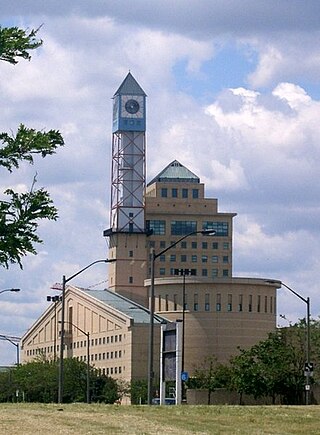
The Mississauga Civic Centre is the seat of local government of Mississauga, Ontario, Canada. The 37,280 square metre complex is a prominent example of postmodern architecture in Canada, finished in 1987 by Jones and Kirkland. It stands at 92 metres or 302 feet. The design was influenced by farmsteads which once occupied much of Mississauga as well as historical features of city centres. The building, for instance, includes a prominent clock tower. It was chosen as the winner of a design competition that included 246 submissions. Mississauga Civic Centre is located in the City Centre near Square One Shopping Centre and is home to the Mississauga City Council. The civic center building is considered one of the most iconic and recognizable buildings and cultural icons of Mississauga city.

<span class="mw-page-title-main">Mississauga Transitway</span> Bus rapid transit system in Mississauga, Ontario

The Mississauga Transitway is a bus rapid transit (BRT) system in Mississauga, Ontario, Canada. It comprises a series of purpose-constructed bus-only roadways, as well as reserved lanes on existing city streets and portions of Highway 403, that together form a continuous 18 km (11 mi) route spanning most of the city from Winston Churchill Boulevard in the west to the junction of Highways 401 and 427 in the east on the border with Toronto. Service on the Transitway is provided by MiWay and GO Transit, with some stations providing connections to Brampton Transit and Toronto Transit Commission (TTC) bus services.

<span class="mw-page-title-main">Square One Bus Terminal</span>

Square One Bus Terminal is a GO Transit intercity bus terminal located in central Mississauga, Ontario, Canada. It is situated directly across Rathburn Road West from the Mississauga City Centre Transit Terminal and the Square One Shopping Centre.

<span class="mw-page-title-main">Hazel McCallion</span> Canadian politician (1921–2023)

Hazel McCallion was a Canadian politician who served as the fifth mayor of Mississauga. First elected in November 1978, McCallion was mayor for 36 years until her retirement in 2014, making her the longest-serving mayor in the city's history. She was a successful candidate in twelve municipal elections, having been acclaimed twice and re-elected ten other times. Her supporters gave her the nickname "Hurricane Hazel" because of her outspoken political style with reference to the hurricane of 1954, which had a considerable impact. When the 1979 Mississauga train derailment occurred early in her tenure, she helped oversee evacuation of 200,000 residents from the resulting explosion, fire, and spill of hazardous chemicals.

<span class="mw-page-title-main">Geography of Mississauga</span>

Mississauga is a city in the Canadian province of Ontario. It is a suburb of Toronto. The city is situated in the Regional Municipality of Peel and covers 288.42 square kilometres (111.36 sq mi) of land, fronting 13 kilometres (8.1 mi) of shoreline on Lake Ontario.

<span class="mw-page-title-main">Hurontario LRT</span> Light rail line under construction in Mississauga and Brampton, Ontario, Canada

The Hurontario LRT is a light rail line under construction in the cities of Mississauga and Brampton, Ontario, Canada. The line will run along Hurontario Street from Mississauga's Port Credit neighbourhood north to Steeles Avenue in Brampton. The line will be built and operated as a public-private partnership by Mobilinx, a consortium of private European and Japanese companies, with provincial transit agency Metrolinx retaining ownership of the line. It will be the only street railway operating in the Greater Toronto Area outside Toronto proper.

<span class="mw-page-title-main">Rockwood Village</span>

Rockwood Village is a neighbourhood in the eastern part of the City of Mississauga, Ontario, in the Regional Municipality of Peel. Its approximate boundaries are Eglinton Avenue in the north, Burnhamthorpe Road in the south, the Etobicoke Creek on the east and Dixie Road on the west. The Municipal Ward is Ward 3, the Ontario Provincial Riding is Mississauga East—Cooksville and the Canadian Federal Riding is Mississauga East—Cooksville. The Burnhamthorpe branch of the Mississauga Library System is located at the southwestern edge of Rockwood Village at the corner of Burnhamthorpe Road and Dixie Road.

<span class="mw-page-title-main">Cooksville Creek</span> River in Ontario, Canada

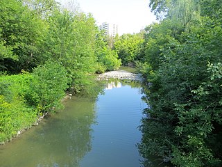
Cooksville Creek is a short stream in Mississauga, Regional Municipality of Peel in the Greater Toronto Area of Ontario, Canada. It begins near Bristol Road West and Hurontario Street and flows south to Lake Ontario at R.K McMilian Park near Lakeshore Road and Cawthra Road. The community of Cooksville is located on the west bank of the creek near Hurontario Street and Dundas Street East. The creek is surrounded mostly by residential homes and a few parks:

Dundas Street bus rapid transit is a proposed bus rapid transit (BRT) corridor proposed by Metrolinx for the western part of the Greater Toronto and Hamilton Area in Southern Ontario, Canada. It is part of the regional transportation plan The Big Move. Metrolinx currently refers to the project as Dundas bus rapid transit without the word "Street". The City of Mississauga used the brand Dundas Connects during the development phase.

<span class="mw-page-title-main">Burnhamthorpe Road</span> Road in the Greater Toronto Area in Ontario, Canada

Burnhamthorpe Road is a major arterial road in the cities of Toronto and Mississauga, Ontario; beginning at Dundas Street, near Islington Avenue, running west and becoming a rural road in the Town of Oakville, where it terminates at Tremaine Road, where it changes name.

<span class="mw-page-title-main">Transportation in Mississauga</span>

The transport infrastructure and services in the Canadian city of Mississauga, Ontario include provincial highways and municipal roads, passenger and freight rail, regional and municipal bus service, and an international airport. It is interconnected with air, road, and rail transportation networks spanning the Greater Toronto Area and beyond.

References

  1. "Aerial photo of original Square One ring road in 1975". City of Toronto Archives (via Eloquent Systems Inc.). Retrieved December 10, 2020.
  2. Google (December 10, 2020). "Street network surrounding Square One in 2018" (Map). Google Maps . Google. Retrieved December 10, 2020.
  3. Mackintosh, Meghan. "Way Back Wednesday: The History of Robert Speck Parkway". Heritage Mississauga. Mississauga Heritage Foundation. Retrieved December 10, 2020.
  4. "Exchange District Condos (Photo of office building being demolished to make may for the Exchange District condos)". Urban Toronto. Retrieved December 10, 2020.
  5. "Map of County of Peel, Ontario, Canada. (1937) Payne's Corner's, located north of Cooksville". Perkins Bull Foundation. Retrieved December 17, 2020.
  6. Urbaniak, Tom (2009). Her Worship: Hazel McCallion and the development of Mississauga. University of Toronto Press. p. 67. ISBN   978-0802096029.
  7. 1 2 "The Rise of the Shopping Centre". Heritage Mississauga. Mississauga Heritage Foundation. Retrieved December 27, 2020.
  8. Urbaniak, Tom (2009). Her Worship: Hazel McCallion and the development of Mississauga. University of Toronto Press. p. 117. ISBN   978-0802096029.
  9. "Our Story". www.kaneff.com. Kaneff Group of Companies. Retrieved December 21, 2020.
  10. "History of Our Office Complex". Mississauga Executive Centre. Retrieved December 21, 2020.
  11. Urbaniak, Tom (2009). Her Worship: Hazel McCallion and the development of Mississauga. University of Toronto Press. p. 118. ISBN   978-0802096029.
  12. Urbaniak, Tom (2009). Her Worship: Hazel McCallion and the development of Mississauga. University of Toronto Press. p. 118,119. ISBN   978-0802096029.
  13. The Canadian Encyclopedia - Mississauga: Present Day Archived 2008-10-05 at the Wayback Machine
  14. Menzies, Joaquim (November 23, 2003). "Mayor tells all at lecture series". The Mississauga News.
  15. "Condo boom puts Toronto atop Crane Index … again". Real Estate News EXchange. 6 April 2020. Retrieved January 2, 2021.
  16. "PSV at Parkside Village, Mississauga | 1195294". Emporis. Archived from the original on July 23, 2021. Retrieved 2022-05-03.
  17. "One Park Tower, Mississauga | 230333". Emporis. Archived from the original on May 14, 2015. Retrieved 2022-05-03.
  18. "Chicago, Mississauga | 302845". Emporis. Retrieved 2022-05-03.[ dead link ]
  19. "One of the Tallest Buildings in Canada is coming to Mississauga" . Retrieved 2021-01-02.
  20. "Avia, Mississauga | 1350824". Emporis. Retrieved 2022-05-03.[ dead link ]
  21. Drawings of Exchange District Condos 1 - SkyscraperPage.com
  22. "The Library". City of Mississauga. 6 March 2019. Retrieved January 2, 2021.
  23. "Y Greater Toronto". YMCA of Greater Toronto. Retrieved January 5, 2021.
  24. "History". livingartscentre.ca. Retrieved December 27, 2020.
  25. "Sheridan College – Hazel McCallion Campus". City of Mississauga. 21 September 2020. Retrieved January 2, 2021.
  26. "Hurontario LRT project page". Metrolinx. Retrieved April 3, 2019.