
Offa's Dyke Path is a long-distance footpath loosely following the Wales–England border. Officially opened on 10 July 1971, by Lord Hunt, it is one of Britain's National Trails and draws walkers from throughout the world. About 60 miles (97 km) of the 177-mile (285 km) route either follows, or keeps close company with, the remnants of Offa's Dyke, an earthwork traditionally thought to have been constructed in the late 8th century on the orders of King Offa of Mercia.

The Berwyn range is an isolated and sparsely populated area of moorland in the northeast of Wales, roughly bounded by Llangollen in the northeast, Corwen in the northwest, Bala in the southwest, and Oswestry in the southeast.

Until 1974, Denbighshire, or the County of Denbigh, was an administrative county in the north of Wales, later classed as one of the thirteen historic counties of Wales. It was a maritime county, that was bounded to the north by the Irish Sea, to the east by Flintshire, Cheshire and Shropshire, to the south by Montgomeryshire and Merionethshire, and to the west by Caernarfonshire.
Cadair Berwyn, Cader Berwyn or Craig Uchaf is a mountain summit in north-east Wales with a height of 832 metres (2,730 ft) above sea level. It is the highest point in the Berwyn range, the highest in North East Wales and the highest significant summit in Wales outside the National Parks. Cadair Berwyn and Foel Cedig to the west are the two Marilyns that form the Berwyn range. The undulating plateau of the range also includes a large number of other summits above 2,000 feet (610 m), including satellite summits of Cadair Berwyn and many which are classed as Nuttalls.

Foel Fenlli or Moel Fenlli is a hill in Denbighshire, North Wales. With a summit at an elevation of 511 metres (1,677 ft), it is the second highest peak of the Clwydian Range.

The Clwydian Range is a series of hills in the north-east of Wales that runs from Llandegla in the south to Prestatyn in the north; the highest point is 554 m (1,818 ft) Moel Famau. The range forms the north-western part of the Clwydian Range and Dee Valley Area of Outstanding Natural Beauty.
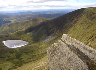
Moel Sych with a height of 826.7 metres (2,712 ft) is a subsidiary summit of Cadair Berwyn in north east Wales. It is the third highest summit in the Berwyn range after Cadair Berwyn and Cadair Berwyn North Top.

The Ruabon Moors are an area of upland moorland in Wales to the west of Ruabon and Wrexham. They lie partly within Wrexham County Borough and partly within Denbighshire.

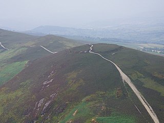
The Horseshoe Pass is a mountain pass in Denbighshire, north-east Wales. It separates Llantysilio Mountain to the west from the 565 metre mountain and Marilyn Cyrn-y-Brain to the east. The A542 road from Llandegla to Llangollen runs through the pass, reaching a maximum height of 417 metres (1,368 ft). The road travels in a horseshoe shape around the sides of a valley, giving the pass its English name. In 2022, a proposal for a 40 mph speed limit on the Horseshoe Pass was approved after a lengthy campaign by Llangollen's county councillors.

Moel y Parc is a hill on the border between Denbighshire and Flintshire in Wales. It is one of the Clwydian Hills, rising 398 metres (1,306 ft) above sea level and is located at OS grid reference SJ114703. There is a television mast near the summit. The summit marks the boundary of Aberwheeler and Ysceifiog communities, and is the site of a cairn and tumulus.

Moel y Cerrig Duon is a subsidiary summit of Esgeiriau Gwynion in Gwynedd in north Wales.
Moel y Gaer may refer to any of several prehistoric hillforts in Wales:

Moel y Gaer, also known as Moel-y-Gaer Camp or Moel y Gaer Hillfort, is an Iron Age hillfort located on a western spur of the Clwydian Range, near the village of Llanbedr, Denbighshire, Wales. The site is a scheduled monument, classified as a prehistoric defensive hillfort.
Moel y Gaer is an Iron Age hillfort on a summit of Llantysilio Mountain, northwest of the town of Llangollen, Denbighshire, Wales. The site is a scheduled monument classified as a prehistoric defensive hillfort.

Clogau Quarry is a quarry which is a Site of Special Scientific Interest located in Denbighshire, Wales. It supports the Llangollen canal, along with the Oernant Quarry. The quarry is used for hearths, worktops, tombstones and billiard tables.

Moel y Garnedd is a hill within the Snowdonia National Park in Gwynedd, North Wales.

Pen Ty-Nant is a hill within the Snowdonia National Park in Gwynedd, North Wales.
The Clwydian Range and Dee Valley is a designated Area of Outstanding Natural Beauty (AONB) located in north-east Wales, covering the Clwydian Range, and the valley of the River Dee.
Oernant Tramway refers to a horse-drawn tramway which connected slate quarries located to the North-West of Llangollen with the Pentrefelin canal wharves at Llantysilio. It is simply referred to as "the tramway" in contemporary publications and appears to have been entirely owned by the Llangollen Slate and Slab Company. The tramway was built in the 1850s, reaching a maximum length approaching seven miles by 1857, and was used until about 1892. It had gravity-worked inclines, and was horse drawn on the level sections.

