Wellington is the capital city of New Zealand. It is located at the south-western tip of the North Island, between Cook Strait and the Remutaka Range. Wellington is the major population centre of the southern North Island, and is the administrative centre of the Wellington Region, which also includes the Kapiti Coast and the Wairarapa. It is the world's southernmost capital of a sovereign state. Wellington features a temperate maritime climate, and is the world's windiest city by average wind speed.
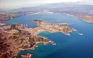
Wellington Harbour is the large natural harbour on the southern tip of New Zealand's North Island. New Zealand's capital city, Wellington, is located on its western side. The harbour, the sea area bounded by a line between Pencarrow Head to Petone foreshore, was officially named Port Nicholson, until it assumed its current name in 1984.

Kelburn is a central suburb of Wellington, the capital city of New Zealand, situated within 1 kilometre (0.62 mi) of the central business district.

Thorndon is a historic inner suburb of Wellington, the capital city of New Zealand. Because the suburb is relatively level compared to the hilly terrain elsewhere in Wellington it contained Wellington's elite residential area until its best was destroyed in the 1960s by a new motorway and the erection of tall office buildings on the sites of its Molesworth Street retail and service businesses.

Lambton Quay is the heart of the central business district of Wellington, the capital city of New Zealand.

The Beehive is the common name for the Executive Wing of New Zealand Parliament Buildings, located at the corner of Molesworth Street and Lambton Quay, Wellington. It is so-called because its shape is reminiscent of that of a traditional woven form of beehive known as a "skep". It is registered as a Category I heritage building by Heritage New Zealand.

New Zealand Parliament Buildings house the New Zealand Parliament and are on a 45,000 square metre site at the northern end of Lambton Quay, Wellington. They consist of the Edwardian neoclassical-style Parliament House (1922); the Parliamentary Library (1899); the executive wing, called "The Beehive" (1977); and Bowen House, in use since 1991. Whilst most of the individual buildings are outstanding for different reasons, the overall setting that has been achieved "has little aesthetic or architectural coherence".

The Wellington Cathedral of St Paul is an Anglican church in the city of Wellington, New Zealand. It is the mother church of the Diocese of Wellington and the cathedral of the Bishop of Wellington. Situated in Thorndon, the main entrance to the cathedral is on Hill Street, at its junction with Molesworth Street; it is located close to the parliament precinct.
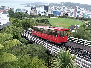
The Wellington Cable Car is a funicular railway in Wellington, New Zealand, between Lambton Quay, the main shopping street, and Kelburn, a suburb in the hills overlooking the central city, rising 120 m (394 ft) over a length of 612 m (2,008 ft).

Old St Paul's is an historic site, a city landmark and a popular wedding and event venue in the heart of Wellington, the capital city of New Zealand. The building served as the pro-cathedral of the Diocese of Wellington of the Anglican Church between 1866 and 1964. It exemplifies 19th-century Gothic Revival architecture adapted to colonial conditions and materials, and stands at 34 Mulgrave Street, Thorndon, close to the parliament precinct.

Wellington railway station is the main railway station serving Wellington, New Zealand, and is the southern terminus of the North Island Main Trunk, Wairarapa Line and Johnsonville Line.

The Te Aro Extension, also known as the Te Aro Branch, was a short branch line railway in Wellington, New Zealand continuing the Wairarapa Line southwards. It operated from 1893 until 1917.
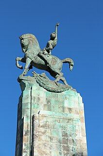
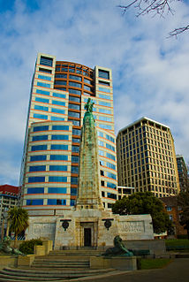
The Wellington Cenotaph, also known as the Wellington Citizens' War Memorial, is a war memorial in Wellington, New Zealand. Commemorating the New Zealand dead of World War I, and World War II. it was unveiled on Anzac Day 1931 and is located on the intersection of Lambton Quay and Bowen Street, by the New Zealand Parliament Buildings. It features two wings decorated with relief sculptures and is topped with a bronze figure on horseback. Two bronze lions and a series of bronze friezes were later added in commemoration of World War II. On 18 March 1982, it was registered as a Category I historic place with registration number 215. It is a focus of Anzac Day commemorations in the city.

Kirkcaldie & Stains was a mid-sized department store in Wellington, New Zealand. It was established in 1863 by John Kirkcaldie and Robert Stains with a capital of £700. The first store was opened on Lambton Quay. In 1868 Kirkcaldie & Staines moved to their final location at the corner of Lambton Quay and Brandon Street, expanding several times. There was a branch in Napier from 1897 until 1917, and a branch on Cuba Street, Wellington for seven years (1871–76). French luxury skincare brand Sisley was exclusive to the store in New Zealand.

The Stewart Dawson's building was a historic building on the corner of Lambton Quay and Willis Street in Wellington, New Zealand. The façade has been retained. Built in 1901 for the London jeweller David Stewart Dawson, it was located on a prominent corner in two of Wellington's major streets, a site particularly important to the history of Wellington, that is commonly known as 'Stewart Dawson's corner'.
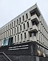
The National Crisis Management Centre (NCMC), also known as the Beehive Bunker, is the New Zealand government crisis management command centre situated under the "Beehive" building in Wellington.

Wellington Central is an inner-city suburb of New Zealand's capital, Wellington. It comprises the northern part of the central business district, with the majority of Wellington's high-rise buildings.

Parliament House in Wellington is the main building of the New Zealand Parliament Buildings. It contains the debating chamber, speaker's office, visitors' centre, and committee rooms. It was built between 1914 and 1922, replacing an earlier building that burned down in 1907. Parliament started using the yet to be completed building from 1918. Parliament House was extensively earthquake strengthened and refurbished between 1991 and 1995. It is open for visitors almost every day of the year, and is one of Wellington's major visitor attractions. Parliament House is a Category I heritage building registered by Heritage New Zealand.
Bowen House is a 22-storey office building on the corner of Lambton Quay and Bowen Street, Wellington, New Zealand, that is leased by the New Zealand Parliament and houses some members of Parliament and government staff.

Lambton originally Wellington railway station in Featherston Street, Wellington, New Zealand was the southern passenger terminus for the Hutt Line and the Wairarapa Line from 1885 to 1936 and for lines further north until December 1908. Wellington's third railway station it had been preceded by station buildings temporarily at Pipitea Point and a site further south on Featherston Street beside Wellington's rail freight depot and its Railway Wharf.