
Perthshire, officially the County of Perth, is a historic county and registration county in central Scotland. Geographically it extends from Strathmore in the east, to the Pass of Drumochter in the north, Rannoch Moor and Ben Lui in the west, and Aberfoyle in the south; it borders the counties of Inverness-shire and Aberdeenshire to the north, Angus to the east, Fife, Kinross-shire, Clackmannanshire, Stirlingshire and Dunbartonshire to the south and Argyllshire to the west. It was a local government county from 1890 to 1930.

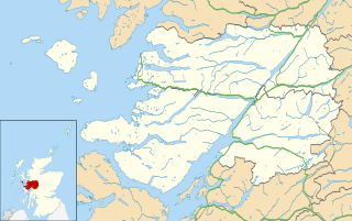
Perth and Kinross is one of the 32 council areas of Scotland and a Lieutenancy Area. It borders onto the Aberdeenshire, Angus, Argyll and Bute, Clackmannanshire, Dundee, Fife, Highland and Stirling council areas. Perth is the administrative centre. With the exception of a large area of south-western Perthshire, the council area mostly corresponds to the historic counties of Perthshire and Kinross-shire.

The River Tay is the longest river in Scotland and the seventh-longest in the United Kingdom. The Tay originates in western Scotland on the slopes of Ben Lui, then flows easterly across the Highlands, through Loch Dochart, Loch Iubhair and Loch Tay, then continues east through Strathtay, in the centre of Scotland, then southeasterly through Perth, where it becomes tidal, to its mouth at the Firth of Tay, south of Dundee. It is the largest river in the UK by measured discharge. Its catchment is approximately 2,000 square miles (5,200 km2), the Tweed's is 1,500 square miles (3,900 km2) and the Spey's is 1,097 square miles (2,840 km2).

Loch Leven is a fresh water loch located immediately to the east of the burgh of Kinross in Perth and Kinross council area, central Scotland. Roughly triangular, the loch is about 6 km (3.7 mi) at its longest. Prior to the canalisation of the River Leven, and the partial draining of the loch in 1826–36, Loch Leven was considerably larger. The drop in water level by 1.4 m reduced to the loch to 75% of its former size, and exposed several small islands, as well as greatly increasing the size of the existing ones.

Loch Lomond and The Trossachs National Park is a national park in Scotland centred on Loch Lomond and the hills and glens of the Trossachs, along with several other ranges of hills. It was the first of the two national parks established by the Scottish Parliament in 2002, the second being the Cairngorms National Park. The park extends to cover much of the western part of the southern highlands, lying to the north of the Glasgow conurbation, and contains many mountains and lochs. It is the fourth largest national park in the British Isles, with a total area of 1,865 km2 (720 sq mi) and a boundary of some 350 km (220 mi) in length. It includes 21 Munros and 20 Corbetts.

The Trossachs generally refers to an area of wooded glens, braes, and lochs lying to the east of Ben Lomond in the Stirling council area of Scotland. The name is taken from that of a small woodland glen that lies at the centre of the area, but is now generally applied to the wider region.
Onich, also spelled Ounich, is a village in the historic county of Inverness-shire on the east shore of Loch Linnhe, Scotland and, together with North Ballachulish at the entrance to Loch Leven, forms Nether Lochaber.

Loch Fleet is a sea loch on the east coast of Scotland, located between Golspie and Dornoch. It forms the estuary of the River Fleet, a small spate river that rises in the hills east of Lairg. The loch was designated a National Nature Reserve (NNR) in 1998, and is managed by a partnership between NatureScot, the Scottish Wildlife Trust (SWT) and Sutherland Estates. The NNR extends to 1058 hectares, including the Loch Fleet tidal basin, sand dunes, shingle ridges and the adjacent pine woods, including Balbair Wood and Ferry Wood. The tidal basin of the loch covers over 630 ha, and forms the largest habitat on the NNR.

Loch Etive is a 30 km sea loch in Argyll and Bute, Scotland. It reaches the sea at Connel, 5 km north of Oban. It measures 31.6 km long and from 1.2 km to 1.6 km (1 mi) wide. Its depth varies greatly, up to a maximum of 150 m (490 ft).

St Abb's Head is a rocky promontory by the village of St Abbs in Berwickshire, Scotland, and a national nature reserve administered by the National Trust for Scotland. St Abb's Head Lighthouse was designed and built by the brothers David Stevenson and Thomas Stevenson and began service on 24 February 1862.
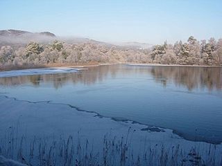
Loch of the Lowes is a loch near Dunkeld in Perth and Kinross, Scotland. The loch and the surrounding area are designated as a wildlife reserve, run by the Scottish Wildlife Trust. The loch is also a designated Site of Special Scientific Interest (SSSI), as well as forming part of a Special Area of Conservation.

Loch of Craiglush is a freshwater loch, located around 1 1⁄2 miles (2.4 km) north-east of Dunkeld in Perth and Kinross, Scotland. The loch is a designated Site of Special Scientific Interest (SSSI), as well as forming part of a Special Area of Conservation.
Loch of Drumellie also known as Marlee Loch or Loch of Marlee is a small lowland freshwater loch that is located 2.3 miles west of Blairgowrie, in Perth and Kinross The loch is also a designated Site of Special Scientific Interest (SSSI), as well as forming part of a Special Area of Conservation.

Rae Loch is a small lowland freshwater loch that sits directly to the east of Loch of Drumellie into which it flows and is 1.5 miles (2.4 km) to the west of Blairgowrie, in Perth and Kinross. The loch is also a designated Site of Special Scientific Interest (SSSI), as well as forming part of a Special Area of Conservation.

Fingask Loch is a small lowland freshwater loch that is about three-quarters of a mile from Rae Loch in the valley of the Lunan Burn and is 1.5 miles south-east of Blairgowrie, in Perth and Kinross. Directly to the east is the smaller White Loch, and next to it is the Black Loch.

White Loch is a small lowland freshwater loch that is located directly to the east of Fingask Loch in the valley of the Lunan Burn and is 1.5 miles south of Blairgowrie, in Perth and Kinross.The loch is also a designated Site of Special Scientific Interest (SSSI), as well as forming part of a Special Area of Conservation.

Black Loch is a small lowland freshwater loch that is located directly to the east of Fingask Loch in the valley of the Lunan Burn and is 1 mile south of Blairgowrie, in Perth and Kinross.
Stormont Loch is a small irregular lowland freshwater loch, that is partially in-filled. It located in a nature reserve owned by the Scottish Wildlife Trust, on a north-east to south-west orientation and is 2 miles southeast of Blairgowrie in Perth and Kinross.

Kinloch is a hamlet and civil parish immediately north of the Loch of Drumellie, about two miles west of Blairgowrie in Perth and Kinross.

