
Monmouthshire is a county in the south east of Wales. It borders Powys to the north; the English counties of Herefordshire and Gloucestershire to the north and east; the Severn Estuary to the south, and Torfaen, Newport and Blaenau Gwent to the west. The largest town is Abergavenny, and the administrative centre is Usk.

Raglan (; is a village and community in Monmouthshire, south-east Wales, United Kingdom. It is located some 9 miles south-west of Monmouth, midway between Monmouth and Abergavenny on the A40 road very near to the junction with the A449 road. It is the location of Raglan Castle, built for William ap Thomas and now maintained by Cadw. The community includes the villages of Llandenny and Pen-y-clawdd. Raglan itself has a population of 1,183.

Llanvihangel Crucorney is a small village in the community (parish) of Crucorney, Monmouthshire, Wales. It is located 5 miles (8.0 km) north of Abergavenny and 18 miles (29 km) southwest of Hereford, England on the A465 road.
Llanfair Kilgeddin is a small village in Monmouthshire, south east Wales, lying within the administrative community of Llanover. It is located four miles north west of Usk and six miles south east of Abergavenny on the B4598 road. The River Usk passes close by.
Dixton is a small village located 1 mile (1.6 km) north east of Monmouth, on the banks of the River Wye, in Monmouthshire, south east Wales. The parish originally comprised the two manors of Dixton Newton and Dixton Hadnock, on either side of the river.
Monmouth Castle is a castle close to the centre of the town of Monmouth, the county town of Monmouthshire, on a hill above the River Monnow in south-east Wales.

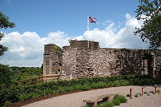
Usk Castle is a castle site in the town of Usk in central Monmouthshire, south east Wales, United Kingdom. It was listed Grade I on 16 February 1953. Within the castle, and incorporating parts of its gatehouse, stands Castle House, a Grade I listed building in its own right.
The Grosmont Railway was an early horse-drawn railway line in Monmouthshire completed in 1819.

Lydart is a dispersed hamlet within the community of Mitchel Troy, Monmouthshire, Wales. It is located about 3 miles (4.8 km) south-west of Monmouth, 3 miles (4.8 km) north of Trellech, and 1 mile (1.6 km) south-east of Mitchel Troy village, on the top of an escarpment which slopes steeply down to the valley of the River Trothy. The B4293 road passes through the area.

Monmouthshire is a county and principal area of Wales. It borders Torfaen and Newport to the west; Herefordshire and Gloucestershire to the east; and Powys to the north. The largest town is Abergavenny, with the other major towns being Chepstow, Monmouth, and Usk. The county is 850 km2 in extent, with a population of 95,200 as of 2020. The present county was formed under the Local Government (Wales) Act 1994, which came into effect in 1996, and comprises some sixty percent of the historic county. Between 1974 and 1996, the county was known by the ancient title of Gwent, recalling the medieval Welsh kingdom. In his essay on local government in the fifth and final volume of the Gwent County History, Robert McCloy suggests that the governance of "no county in the United Kingdom in the twentieth century was so transformed as that of Monmouthshire".
Monmouthshire is a county of Wales. It borders Torfaen and Newport to the west; Herefordshire and Gloucestershire to the east; and Powys to the north. The largest town is Abergavenny, with the other major towns being Chepstow, Monmouth, and Usk. The county is 850 km2 in extent, with a population of 95,200 as of 2020. The present county was formed under the Local Government (Wales) Act 1994, which came into effect in 1996, and comprises some sixty percent of the historic county. Between 1974 and 1996, the county was known by the ancient title of Gwent, recalling the medieval Welsh kingdom. In his essay on local government in the fifth and final volume of the Gwent County History, Robert McCloy suggests that the governance of "no county in the United Kingdom in the twentieth century was so transformed as that of Monmouthshire".

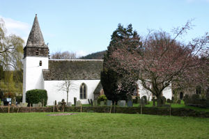
St Cenedlon's is a parish church in the village of Rockfield, Monmouthshire, Wales. The dedication to St Cenedlon is unusual and the history of the saint is obscure. Some sources suggest that she was a daughter of Brychan king of Brycheiniog while others identify her as the wife of King Arthfael ab Ithel, king of Glywysing. The existing church dates from the Middle Ages but only the tower remains from that period. After the English Reformation, the surrounding area of north Monmouthshire became a refuge for Catholics and Matthew Pritchard (1669-1750), Roman Catholic bishop and Vicar Apostolic of the Western District is buried at the church. By the mid-19th century the church was in ruins and a complete reconstruction was undertaken by the ecclesiastical architects John Pollard Seddon and John Prichard in around 1860. St Cenedlon's is an active parish church in the Diocese of Monmouth. It is designated by Cadw as a Grade II listed building.

The Redbrook Incline Bridge is a nineteenth-century tramway bridge that crosses the B4231 road at Redbrook on the England–Wales border. The bridge straddles the border and stands in the counties of Monmouthshire in Wales and Gloucestershire in England. It was built as a branch line from the Monmouth Tramroad to transport coal to the Redbrook Tinplate Works and was constructed on a significant incline as a consequence of its standing well below the main tramway. It is a remarkable survival of 19th-century industrialisation in the Wye Valley and is both a Grade II* and a Grade II listed structure, and a scheduled monument.

Little Llwygy Farmhouse, Cwmyoy, Monmouthshire, Wales, is a farmhouse of two building dates, the earlier of the 15th century, the latter of the 17th. The farmhouse is a Grade II* listed building.

Ty-Hwnt-y-Bwlch Farmhouse,, Cwmyoy, Monmouthshire is a farmhouse in the north of the county dating from the late 16th century. Located on the hillside above the Church of St Martin, it is a Grade II* listed building.

Sleath Farmhouse, Llangua, Monmouthshire is a farmhouse dating from the mid 16th century. Standing close to the Church of St James, in the far north of the county close to the border with Herefordshire, the farmhouse is a Grade II* listed building, its listing noting that it is an "extremely rare survival" of a Welsh framed hall house.
The Llanvihangel Railway was an early horse-drawn railway line in Monmouthshire which operated over a 6.25 mile route between the Brecknock and Abergavenny Canal and Llanvihangel Crucorney from 1814 until 1846. The act of Parliament for the railway, the Llanvihangel Railway Act 1811, received royal assent on 25 May 1811. The line was initially constructed only as far as Blaengavenny and it was 1820 or 1821 before it was extended to Llanvihangel.

Perth-hir House, Rockfield, Monmouthshire, Wales, was a major residence of the Herbert family. It stood at a bend of the River Monnow, to the north-west of the village. At its height in the 16th century, the mansion, entered by two drawbridges over a moat, comprised a great hall and a number of secondary structures. Subsequently in the ownership of the Powells, and then the Lorimers, the house became a centre of Catholic recusancy following the English Reformation. By the 19th century, the house had declined to the status of a farmhouse and it was largely demolished in around 1830. Its ruins, and the site which contains considerable remnants of a Tudor garden, are a scheduled monument.
Monmouthshire is a county of Wales. It borders Torfaen and Newport to the west; Herefordshire and Gloucestershire to the east; and Powys to the north. The largest town is Abergavenny, with other large settlements being Chepstow, Monmouth, and Usk. The present county was formed under the Local Government (Wales) Act 1994, which came into effect in 1996. It has an area of 850 km2 (330 sq mi), with a population of 93,200 as of 2021. Monmouthshire comprises some sixty per cent of the historic county, and was known as Gwent between 1974 and 1996.

Abergavenny Priory Deer Park, to the north of the town of Abergavenny in Monmouthshire, Wales, was a mediaeval deer park. Today, the site is listed on the Cadw/ICOMOS Register of Parks and Gardens of Special Historic Interest in Wales.

