Related Research Articles
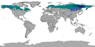
The subarctic climate is a climate with long, cold winters, and short, warm to cool summers. It is found on large landmasses, often away from the moderating effects of an ocean, generally at latitudes from 50° to 70°N, poleward of the humid continental climates. Subarctic or boreal climates are the source regions for the cold air that affects temperate latitudes to the south in winter. These climates represent Köppen climate classification Dfc, Dwc, Dsc, Dfd, Dwd and Dsd.

Located in the eastern part of Canada, and part of Central Canada, Quebec occupies a territory nearly three times the size of France or Texas, and is much closer to the size of Alaska. As is the case with Alaska, most of the land in Quebec is very sparsely populated. Its topography is very different from one region to another due to the varying composition of the ground, the climate, and the proximity to water. The Great Lakes–St. Lawrence Lowlands and the Appalachians are the two main topographic regions in southern Quebec, while the Canadian Shield occupies most of central and northern Quebec.
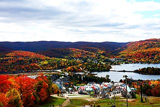
Mont Tremblant Ski Resort is a year-round resort in the Laurentian Mountains of Quebec, Canada, located about 130 km (80 mi) northwest of Montreal. It is best known as a ski destination, but also features Lake Tremblant suitable for swimming and two golf courses in the summer months. The name of the mountain, Mont Tremblant, was derived from the Algonquin indigenous people, who called it the "trembling mountain." The summit is at an elevation of 875 m (2,871 ft), which makes it one of the tallest peaks in the Laurentians. One km north of the principal down hill area is the Edge, an area of glade skiing and 2.8 km (1.7 mi) north of that is the true summit, Pic Johanssen, which has a trail over the top and is Black Diamond for skiers and boarders. The resort is owned by Alterra Mountain Company.

Cypress Mountain is a ski area in West Vancouver, British Columbia, Canada, located in the southern section of Cypress Provincial Park, operated under a BC Parks Park Use Permit.

Togwotee Pass is a high mountain pass in the western United States, at an elevation of 9,655 feet (2,943 m) above sea level. On the Continental Divide in the Absaroka Mountains of northwestern Wyoming in Teton County, it is between Dubois and Moran Junction in the Jackson Hole valley.

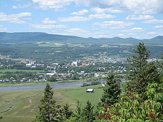
La Malbaie is a municipality in the Charlevoix-Est Regional County Municipality in the Province of Quebec, Canada, situated on the north shore of the St. Lawrence River at the mouth of the Malbaie River. It was formerly known as Murray Bay. La Malbaie is the seat of the judicial district of Charlevoix.

The Malbaie River in the Charlevoix region empties into the Saint Lawrence River at La Malbaie. Until 1985 the river was used to transport logs downstream. It flows through a steep valley known as Les Hautes Gorges. A sugar maple and American elm forest grows in the gorge and has remained largely undisturbed for hundreds of years.

The Hautes-Gorges-de-la-Rivière-Malbaie National Park is a provincial park in the Charlevoix region of Quebec, Canada. Centring on the Malbaie River Gorge, it is the centrepiece of the UNESCO Charlevoix biosphere reserve. Despite its name, it is not in Canada's national park system, nor administered by Parks Canada. It is administered by the Société des établissements de plein air du Québec (Sépaq). The park can be reached via a local road, 30 kilometers (19 mi) northwards from Route 138 in Saint-Aimé-des-Lacs.

Le Massif de Charlevoix, known as just Le Massif, is a ski area in Quebec, Canada, northeast of Quebec City and directly overlooking the St. Lawrence River.
The Massif du Sud is a ski mountain about 90 km (60 mi) southeast of Quebec City, Canada. It is part of the park of the same name, the Parc du Massif du Sud.

Grands-Jardins National Park is a provincial park, located in the Unorganized Territory of Lac-Pikauba, in the Charlevoix Regional County Municipality, an administrative region of Capitale-Nationale, in Quebec, Canada.

Mont-Élie is an unorganized territory in the Capitale-Nationale region of Quebec, Canada. It makes up almost 38% of the Charlevoix-Est Regional County Municipality.

The Train de Charlevoix is a tourist rail service between Beauport and La Malbaie, Quebec, with an additional stop in Baie-Saint-Paul and in the winter at the Le Massif ski area, a distance of about 140 kilometres (87 mi). It is owned and operated by Le Massif de Charlevoix, which also owns the Le Massif ski area.
The Montagne des Érables, also known as Mont des Érables, is a massif located in the Charlevoix-Est regional county municipality in the Charlevoix region of Quebec, Canada. It lies in the Hautes-Gorges-de-la-Rivière-Malbaie National Park and is home to l'Acropole des Draveurs, a popular hike in the province. It is accessible via the entrances to the park, the main one being located in Saint-Aimé-des-Lacs.
The Ultra-Trail Harricana of Canada, also referred to as the UTHC and formerly known as XC Harricana, is an annual trail running event founded in 2011 that takes place at the Mont Grand-Fonds ski centre, 15 km (9.3 mi) from the town of La Malbaie, Québec. The courses make use of the ski centre's slopes as well as trails in the Traversée de Charlevoix hiking area and in the Hautes-Gorges-de-la-Rivière-Malbaie National Park. The event is a qualifying race for the Ultra-Trail du Mont-Blanc and the Western States 100. It is also one of the toughest ultra-trail races in Eastern Canada. On November 5, 2015, Ultra-Trail Harricana was named a "race of the future" by the Ultra-Trail World Tour and officially became part of the Tour in 2017.
The Comporté River is a tributary of the Malbaie River flowing generally southward into the territory of the town of La Malbaie in the Eastern part of the Charlevoix Regional County Municipality, in Quebec, in Canada. This river has a gap in elevation of 489 m (1,604 ft). After several series of rapids, waterfalls and falls in forest area, it flows into the Malbaie River between the village of Clermont and the town of La Malbaie.

The rivière du Gouffre is a tributary of the left bank of the Saint-Laurent river, flowing into the Capitale-Nationale administrative region, Quebec (Canada). This watercourse flows through Regional County Municipality from:
The Charlevoix Biosphere Reserve is part of the Man and the Biosphere Program of the UNESCO. It is managed by the Charlevoix Biosphere Reserve Corporation.

The mont du Lac à Moïse is a mountain of the Jacques-Cartier Massif located within the Grands-Jardins National Park, in the unorganized territory of Lac-Pikauba, in the Charlevoix Regional County Municipality, in the administrative region of Capitale-Nationale, in Quebec, in Canada. It peaks at 960 metres (3,150 ft).
References
- ↑ "Interactive Canada Koppen-Geiger Climate Classification Map". www.plantmaps.com. Retrieved 2019-11-21.
- ↑ "Mont Grand-Fonds - La Malbaie | Cross-country ski centres - Charlevoix". QuébecOriginal. Retrieved 2019-11-21.
- ↑ "Canadian Climate Normals 1971-2000 - Grand Fonds". Environment Canada . Retrieved November 21, 2019.