
Qt is a free as in "freedom" cross-platform software for creating graphical user interfaces as well as cross-platform applications that run on various software and hardware platforms such as Linux, Windows, macOS, Android or embedded systems with little or no change in the underlying codebase while still being a native application with native capabilities and speed.

Photomontage is the process and the result of making a composite photograph by cutting, gluing, rearranging and overlapping two or more photographs into a new image. Sometimes the resulting composite image is photographed so that the final image may appear as a seamless physical print. A similar method, although one that does not use film, is realized today through image-editing software. This latter technique is referred to by professionals as "compositing", and in casual usage is often called "photoshopping". A composite of related photographs to extend a view of a single scene or subject would not be labeled as a montage, but instead a stitched image or a digital image mosaic.
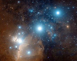
Astrophotography, also known as astronomical imaging, is the photography or imaging of astronomical objects, celestial events, or areas of the night sky. The first photograph of an astronomical object was taken in 1840, but it was not until the late 19th century that advances in technology allowed for detailed stellar photography. Besides being able to record the details of extended objects such as the Moon, Sun, and planets, modern astrophotography has the ability to image objects outside of the visible spectrum of the human eye such as dim stars, nebulae, and galaxies. This is accomplished through long time exposure as both film and digital cameras can accumulate and sum photons over long periods of time or using specialized optical filters which limit the photons to a certain wavelength.

In photography and videography, multi-exposure HDR capture is a technique that creates extended or high dynamic range (HDR) images by taking and combining multiple exposures of the same subject matter at different exposure levels. Combining multiple images in this way results in an image with a greater dynamic range than what would be possible by taking one single image. The technique can also be used to capture video by taking and combining multiple exposures for each frame of the video. The term "HDR" is used frequently to refer to the process of creating HDR images from multiple exposures. Many smartphones have an automated HDR feature that relies on computational imaging techniques to capture and combine multiple exposures.

Photometry, from Greek photo- ("light") and -metry ("measure"), is a technique used in astronomy that is concerned with measuring the flux or intensity of light radiated by astronomical objects. This light is measured through a telescope using a photometer, often made using electronic devices such as a CCD photometer or a photoelectric photometer that converts light into an electric current by the photoelectric effect. When calibrated against standard stars of known intensity and colour, photometers can measure the brightness or apparent magnitude of celestial objects.
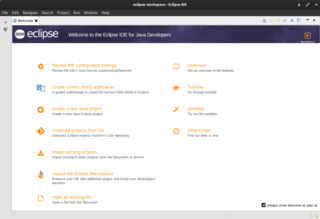
Eclipse is an integrated development environment (IDE) used in computer programming. It contains a base workspace and an extensible plug-in system for customizing the environment. It is the second-most-popular IDE for Java development, and, until 2016, was the most popular. Eclipse is written mostly in Java and its primary use is for developing Java applications, but it may also be used to develop applications in other programming languages via plug-ins, including Ada, ABAP, C, C++, C#, Clojure, COBOL, D, Erlang, Fortran, Groovy, Haskell, JavaScript, Julia, Lasso, Lua, NATURAL, Perl, PHP, Prolog, Python, R, Ruby, Rust, Scala, and Scheme. It can also be used to develop documents with LaTeX and packages for the software Mathematica. Development environments include the Eclipse Java development tools (JDT) for Java and Scala, Eclipse CDT for C/C++, and Eclipse PDT for PHP, among others.

Remote sensing is the acquisition of information about an object or phenomenon without making physical contact with the object, in contrast to in situ or on-site observation. The term is applied especially to acquiring information about Earth and other planets. Remote sensing is used in numerous fields, including geophysics, geography, land surveying and most Earth science disciplines ; it also has military, intelligence, commercial, economic, planning, and humanitarian applications, among others.
Visual effects is the process by which imagery is created or manipulated outside the context of a live-action shot in filmmaking and video production. The integration of live-action footage and other live-action footage or CGI elements to create realistic imagery is called VFX.
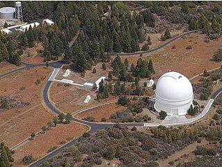
Palomar Observatory is an astronomical research observatory in San Diego County, California, United States, in the Palomar Mountain Range. It is owned and operated by the California Institute of Technology (Caltech). Research time at the observatory is granted to Caltech and its research partners, which include the Jet Propulsion Laboratory (JPL), Yale University, and the National Optical Observatories of China.

The Standard Widget Toolkit (SWT) is a graphical widget toolkit for use with the Java platform. It was originally developed by Stephen Northover at IBM and is now maintained by the Eclipse Foundation in tandem with the Eclipse IDE. It is an alternative to the Abstract Window Toolkit (AWT) and Swing Java graphical user interface (GUI) toolkits provided by Sun Microsystems as part of the Java Platform, Standard Edition (J2SE).

NASA WorldWind is an open-source virtual globe. According to the website, "WorldWind is an open source virtual globe API. WorldWind allows developers to quickly and easily create interactive visualizations of 3D globe, map and geographical information. Organizations around the world use WorldWind to monitor weather patterns, visualize cities and terrain, track vehicle movement, analyze geospatial data and educate humanity about the Earth." It was first developed by NASA in 2003 for use on personal computers and then further developed in concert with the open source community since 2004. As of 2017, a web-based version of WorldWind is available online. An Android version is also available.

Google Earth is a computer program that renders a 3D representation of Earth based primarily on satellite imagery. The program maps the Earth by superimposing satellite images, aerial photography, and GIS data onto a 3D globe, allowing users to see cities and landscapes from various angles. Users can explore the globe by entering addresses and coordinates, or by using a keyboard or mouse. The program can also be downloaded on a smartphone or tablet, using a touch screen or stylus to navigate. Users may use the program to add their own data using Keyhole Markup Language and upload them through various sources, such as forums or blogs. Google Earth is able to show various kinds of images overlaid on the surface of the earth and is also a Web Map Service client. In 2019, Google has revealed that Google Earth now covers more than 97 percent of the world, and has captured 10 million miles of Street View imagery.

Image stitching or photo stitching is the process of combining multiple photographic images with overlapping fields of view to produce a segmented panorama or high-resolution image. Commonly performed through the use of computer software, most approaches to image stitching require nearly exact overlaps between images and identical exposures to produce seamless results, although some stitching algorithms actually benefit from differently exposed images by doing high-dynamic-range imaging in regions of overlap. Some digital cameras can stitch their photos internally.

GCompris is a software suite comprising educational entertainment software for children aged 2 to 10. GCompris was originally written in C and Python using the GTK+ widget toolkit, but a rewrite in C++ and QML using the Qt widget toolkit has been undertaken since early 2014. GCompris is free and open-source software and the current version is subject to the requirements of the AGPL-3.0-only license. It has been part of the GNU project.

Nuke is a node-based digital compositing and visual effects application first developed by Digital Domain, and used for television and film post-production. Nuke is available for Microsoft Windows 7, OS X 10.9, Red Hat Enterprise Linux 5, and newer versions of these operating systems. Foundry has further developed the software since Nuke was sold in 2007.
ITK is a cross-platform, open-source application development framework widely used for the development of image segmentation and image registration programs. Segmentation is the process of identifying and classifying data found in a digitally sampled representation. Typically the sampled representation is an image acquired from such medical instrumentation as CT or MRI scanners. Registration is the task of aligning or developing correspondences between data. For example, in the medical environment, a CT scan may be aligned with an MRI scan in order to combine the information contained in both.
Opticks is a remote sensing application that supports imagery, video, synthetic aperture radar (SAR), multi-spectral, hyper-spectral, and other types of remote sensing data. Opticks supports processing remote sensing video in the same manner as it supports imagery, which differentiates it from other remote sensing applications. Opticks was initially developed by Ball Aerospace & Technologies Corp. and other organizations for the United States Intelligence Community. Ball Aerospace open sourced Opticks hoping to increase the demand for remote sensing data and broaden the features available in existing remote sensing software. The Opticks software and its extensions are developed by over twenty different organizations, and over two hundred users are registered users at http://opticks.org. Future planned enhancements include adding the ability to ingest and visualize lidar data, as well as a three-dimensional (3-D) visualization capability.

The Image-Guided Surgery Toolkit is a software package oriented to facilitate the development of image-guided surgery applications.

MeVisLab is a cross-platform application framework for medical image processing and scientific visualization. It includes advanced algorithms for image registration, segmentation, and quantitative morphological and functional image analysis. An IDE for graphical programming and rapid user interface prototyping is available.

The Aphelion Imaging Software Suite is a software suite that includes three base products - Aphelion Lab, Aphelion Dev, and Aphelion SDK for addressing image processing and image analysis applications. The suite also includes a set of extension programs to implement specific vertical applications that benefit from imaging techniques.
