Related Research Articles

Nye County is a county in the U.S. state of Nevada. As of the 2010 census, the population was 43,946. Its county seat is Tonopah. At 18,159 square miles (47,030 km2), Nye is Nevada's largest county by area and the third-largest county in the contiguous United States, behind Coconino County of Arizona and San Bernardino County of California.

Esmeralda County is a county in the west of the U.S. state of Nevada. As of the Census American Community Survey 2019, the population was 969, making it the least populous county in Nevada. Esmeralda County does not have any incorporated communities. Its county seat is the town of Goldfield.

The Reese River is a 181-mile-long (291 km) tributary of the Humboldt River, located in central Nevada in the western United States.
Monte Cristo or Montecristo may refer to:

Nevadia is an extinct genus of trilobites, fossil marine arthropods, with species of average size. It lived during the Atdabanian stage, which lasted from 530 to 524 million years ago, in what are today Western Canada, the Western United States, and Mexico.

The Simpson Park Mountains, also known as the Simpson Park Range, are located in Lander and Eureka counties, in central Nevada in the western United States. The mountains reach an elevation of 9,147 feet (2,788 m) at Fagin Mountain, and cover an area of approximately 310 square miles (800 km2). US Route 50 crosses the very southern end of the range at Hickison Summit between Eureka and Austin.

Josiah Edward Spurr (1870–1950) was an American geologist, explorer, and author. Born in Gloucester, Massachusetts, he was considered something of a failure as a youth, unsuited for the family fishing business, since on a voyage he invariably became seasick. Since he could not be a productive fisherman like his brothers, his parents decided he might as well go to college. After working his way through Harvard, he began his career with the Minnesota Geological Survey, making the first-ever geological map of the great Mesabi iron range in Minnesota.
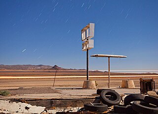
Coaldale is a former mining town and true ghost town in Esmeralda County, Nevada, located at the junction of U.S. Route 6 and U.S. Route 95 about 40 miles (64 km) west of Tonopah.
Fish Lake Valley is a ghost town located in the geographic Fish Lake Valley, within Esmeralda County, Nevada and Inyo County, California.

The Cactus Range is a small mountain range in Nye County, Nevada. The range lies southwest of Cactus Flat and north of Pahute Mesa. Goldfield lies 23 mi (37 km) to the west in Esmeralda County. The range lies within the restricted area of the Tonopah Test Range.
The Cedar Mountains, also known as the Hardscrabble Mountains, are located in western Nevada in the United States. The mountain range lay north of the Monte Cristo Range about 30 miles (48 km) north of Tonopah in Mineral County and its highest point is Little Pilot Peak. This mountain range is situated in the Walker Lane region, which is part of the boundary between the Pacific Plate and the North American Plate, similar to the San Andreas Fault in to the west in California. Cedar Mountains was named for the cedar timber in the area. It was the site of a magnitude 7.2 earthquake on December 20, 1932 that was felt throughout much of the west.
The Monte Cristo Mountains are a mountain range in Nye County, Nevada.
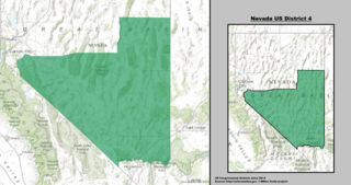
Nevada's 4th congressional district is a congressional district that was created as a result of the 2010 United States Census. Located in the central portion of the state, it includes most of northern Clark County, southern Lyon County and all of Esmeralda, Lincoln, Mineral, Nye and White Pine counties.
Monte Cristo Natural Area Preserve in Klickitat County, Washington is part of the Washington Natural Areas Program. It protects 1,151 acres (466 ha) in the eastern Cascade Mountains owned by the Washington Department of Natural Resources. The landscape includes grand fir and Douglas fir forest, dry grassland, and shrubland with patches of Oregon white oak - Frémont silktassel chaparral.

Monte Cristo was a mining camp in Sierra County in the U.S. state of California, near California State Route 49 and Downieville. Monte Cristo can be reached by trails from Downieville. One of the main trails is at the ridge between Goodyears Creek and the North Fork of the North Yuba River. There are views of the Excelsior Mine on Goodyears Creek four miles northwest of Downieville near Monte Cristo. Goodyears Bar, California is nearby. The mines at Fir Cap, two miles from Monte Cristo, were once rich with gold.
On May 15, 2020 at 4:03:27 local time, a magnitude 6.5 earthquake struck ~35 miles (56 km) west of Tonopah, Nevada in the Monte Cristo Range near the California-Nevada border. It was Nevada's largest earthquake in 66 years.
The Cedar Mountain earthquake of 1932 was one of the largest seismic events in the US state of Nevada. The 7.2 magnitude earthquake struck at the base of Cedar Mountain in Western Nevada. Shaking from this earthquake was felt as far as Oregon, Southern California, and the Rocky Mountains area. Nevada is the third most seismically active state in the United States due to ongoing rifting occurring within the North American Plate. Extension or thinning of the crust has resulted in numerous faults accommodating strain, at the same time, producing earthquakes. Since the earthquake took place in a remote area of the state, there were slight damages but no deaths were reported.
Cirac Valley is a valley, located in the Battle Mountain District, in Esmeralda County, Nevada, United States. It covers an land area of 23,940 acres.
References
- "Volcanic and Sedimentary Rocks of the Monte Cristo Range, Esmeralda County, Nevada", University of Nevada, Reno
- Biological Resources Research Center -
- Nevada Atlas & Gazetteer, 2001, pg. 52
Coordinates: 38°08′20″N117°47′17″W / 38.139°N 117.788°W
| | This Esmeralda County, Nevada state location article is a stub. You can help Wikipedia by expanding it. |