
Ceuta is a Spanish autonomous city on the north coast of Africa.

The Mediterranean Sea is a sea connected to the Atlantic Ocean, surrounded by the Mediterranean Basin and almost completely enclosed by land: on the north by Southern Europe and Anatolia, on the south by North Africa, and on the east by the Levant in West Asia. The Mediterranean has played a central role in the history of Western civilization. Geological evidence indicates that around 5.9 million years ago the Mediterranean was cut off from the Atlantic and was partly or completely desiccated over a period of some 600,000 years during the Messinian salinity crisis before being refilled by the Zanclean flood about 5.3 million years ago.

Spain is a country located in southwestern Europe occupying most of the Iberian Peninsula. It also includes a small exclave inside France called Llívia, as well as the Balearic Islands in the Mediterranean, the Canary Islands in the Atlantic Ocean 108 km (67 mi) off northwest Africa, and five places of sovereignty on and off the coast of North Africa: Ceuta, Melilla, Islas Chafarinas, Peñón de Alhucemas, and Peñón de Vélez de la Gomera.

The Strait of Gibraltar, also known as the Straits of Gibraltar, is a narrow strait that connects the Atlantic Ocean to the Mediterranean Sea and separates Europe from Africa.

The Rock of Gibraltar is a monolithic limestone promontory located in the British territory of Gibraltar, near the southwestern tip of Europe on the Iberian Peninsula, and near the entrance to the Mediterranean. It is 426 m (1,398 ft) high. Most of the Rock's upper area is covered by a nature reserve, which is home to around 300 Barbary macaques. These macaques, as well as a labyrinthine network of tunnels, attract many tourists each year.

Jebel Musa is a mountain in the northernmost part of Morocco, on the African side of the Strait of Gibraltar. It is part of the Rif mountain chain. The mountain is generally identified as the southern Pillar of Hercules, Abila Mons.

The Alboran Sea is the westernmost portion of the Mediterranean Sea, lying between the Iberian Peninsula and the north of Africa. The Strait of Gibraltar, which lies at the west end of the Alboran Sea, connects the Mediterranean with the Atlantic Ocean.
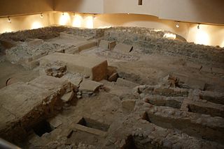
Abyla was the pre-Roman name of Ad Septem Fratres. Ad Septem Fratres, usually shortened to Septem or Septa, was a Roman colony in the province of Mauretania Tingitana and a Byzantine outpost in the exarchate of Africa. Its ruins are located within present-day Ceuta, an autonomous Spanish city in northwest Africa.

Rusadir was an ancient Punic and Roman town at what is now Melilla, Spain, in northwest Africa. Under the Roman Empire, it was a colony in the province of Mauretania Tingitana.
The Bay of Ceuta is a bay on the African coast of the Straits of Gibraltar. It accounts for the majority of the north coast of the Spanish city of Ceuta. It stretches from Punta Blanca in the west to Isla de Santa Catalina, off the coast of the Península de Almina in the east, a distance of eight kilometres. Ceuta's harbour lies on the bay.

The Península de Almina is a peninsula making up much of the eastern part of the Spanish city of Ceuta in Africa. It is dominated by the peak of Monte Hacho. The peninsula contains Ceuta's easternmost point, Punta Almina, and is connected to the rest of Ceuta by an isthmus barely 100 metres (330 ft) in width.

Benzú is a small settlement within the Spanish autonomous city of Ceuta. It has a population of 1,987 according to the 2011 census, divided into two units with Ceuta as its municipality.

The history of Gibraltar, a small peninsula on the southern Iberian coast near the entrance of the Mediterranean Sea, spans over 2,900 years. The peninsula has evolved from a place of reverence in ancient times into "one of the most densely fortified and fought-over places in Europe", as one historian has put it. Gibraltar's location has given it an outsized significance in the history of Europe and its fortified town, established in the Middle Ages, has hosted garrisons that sustained numerous sieges and battles over the centuries.
Abily is an old Russian male first name. Included into various, often handwritten, church calendars throughout the 17th–19th centuries, it was omitted from the official Synodal Menologium at the end of the 19th century. It is possibly derived from "Абила" (Abila)—the name of one of the Pillars of Hercules associated with modern Monte Hacho on the north coast of Africa.
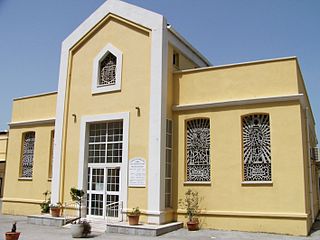
St. Bernard's Church is one of eight Roman Catholic churches in the British Overseas Territory of Gibraltar.
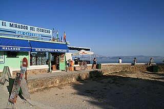
The Mirador del Estrecho is a scenic overlook over the Strait of Gibraltar located within the municipal borders of Tarifa, Spain, 6 kilometres (3.7 mi) from its urban centre. The overlook is 300 metres (980 ft) above sea level and can be reached via the N-340 road.

The Caves of Hercules is an archaeological cave complex located in Cape Spartel, Morocco.

Cape Spartel is a promontory in Morocco about 1,000 feet (300 m) above sea level at the entrance to the Strait of Gibraltar, 12 km west of Tangier, and the northwesternmost point of the African continent. Below the cape are the Caves of Hercules.

The topographical relief of Spain is characterized by being quite high, with an average altitude of 660 meters above sea level, quite mountainous compared to other European countries and only surpassed by Switzerland, Austria, Greece and the microstates of Andorra and Liechtenstein. In peninsular Spain, the terrain is articulated around a large Meseta Central that occupies most of the center of the Iberian Peninsula. Outside the plateau, there is the depression of the Guadalquivir river, located in the southwest of the peninsula, and the Ebro river depression, located in the northeast.

