Monte San Biagio

Last updated
Monte San Biagio
Comune di Monte San Biagio
MonteSanBiagio.jpg
MonteSanBiagio-Stemma.gif
Location of Monte San Biagio
Monte San Biagio
Italy provincial location map 2016.svg
Red pog.svg
Monte San Biagio
Location of Monte San Biagio in Italy
Italy Lazio location map.svg
Red pog.svg
Monte San Biagio
Monte San Biagio (Lazio)
Coordinates: 41°21′N13°21′E / 41.350°N 13.350°E / 41.350; 13.350
Country Italy
Region Lazio
Province Latina (LT)
Frazioni Campo Marinella, Pieterte, San Vito, Valle Viola Bassa, Vallemarina, Vallemarina Iannace, Vallemarina Scorzaro
Government
  MayorFederico Carnevale
Area
[1]
  Total66 km2 (25 sq mi)
Elevation
133 m (436 ft)
Population
 (31 March 2017) [2]
  Total6,324
  Density96/km2 (250/sq mi)
Demonym Monticellani
Time zone UTC+1 (CET)
  Summer (DST) UTC+2 (CEST)
Postal code
04020
Dialing code 0771
Patron saintSt. Blaise
Saint dayFebruary 3
Website Official website

Monte San Biagio (Southern Laziale: Muntciegl) is a town and comune in the province of Latina, in southern Lazio (Italy). It is located on the slope of a hill part of the Monti Ausoni. Until 1862 it was known as Monticello.

Contents

History and main sights

The Roman presence in Monte San Biagio's territory is testified by the presence of a mausoleum attributed to Emperor Galba, a native of the area, but which probably belonged to Sextus Iulius Frontinus, who had a great villa in the vicinity.[ citation needed ] The Romans defeated the Samnites here, at the Passo della Portella: in the place a fortified gate was built, which was later used as the border customs of the Kingdom of Naples. Nearby is a watchtower from the period of Pope Sixtus V.

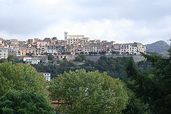
The origins of the modern town date back to the Middle Ages, when a castle was built here (over the Roman ruins), firstly as a stronghold of the Duchy of Gaeta, and later of the Duchy of Fondi. The first document mentioning the Castrum Monticelli, however, dates from 1099, from the archives of Monte Cassino. In the following centuries it was a fief of Fondi, a possession of the dell'Aquila family from 1145. Later it was ruled by the Colonna, the Carafa, the Mansfeld and the Di Sangro, as part of the Kingdom of Naples.

In the winter of 1788 the town was sacked by the French army, while, after the Bourbon restoration and the subsequent unification of Italy, the neighbourhood was the base of brigandage. In 1862 the name was changed to Monte San Vito and, soon thereafter, to the current Monte San Biagio.

Transportation

Monte San Biagio lies next to the Via Appia, once the main road from Rome to Campania. It is also connected by a branch of the Via Flacca from Terracina to Gaeta.[ citation needed ]

The town is served by a railway station on the mainline between Rome and Naples.

Traditions and gastronomic specialities

There are several dishes particular to Monte San Biagio, some using shrimp from the local lakes, and wild asparagus. The pork sausages are particularly distinctive, usually handmade from the meat and lard of the pig, mixed with chilli pepper and coriander seed.

It is also home to 300 hectares (740 acres) of cork oak woods, one of the few areas of production outside of Sardinia.

The communes of Monte San Biagio, Sonnino and Terracina itself are those sanctioned to produce Moscato di Terracina wines, the finest of which come from vineyards on the southeast-facing slopes of the coastal hills.

The plains of Monte San Biagio, south of Monti Ausoni, are primarily used for agriculture including the growth of kiwi, olives, pears, citrus fruits, and many types of vegetables.

Climate

Monte San Biagio has a Mediterranean climate (Köppen climate classification: Csa),with hot, dry summers and mild, humid winters.

Twin cities

Related Research Articles

<span class="mw-page-title-main">Gaeta</span> Comune in Lazio, Italy

Gaeta is a city in the province of Latina, in Lazio, Southern Italy. Set on a promontory stretching towards the Gulf of Gaeta, it is 120 kilometres from Rome and 80 km (50 mi) from Naples.

Formia is a city and comune in the province of Latina, on the Mediterranean coast of Lazio, Italy. It is located halfway between Rome and Naples, and lies on the Roman-era Appian Way. It has a population of 38,095.

<span class="mw-page-title-main">Itri</span> Comune in Lazio, Italy

Itri is a small city and comune the province of Latina, Lazio, central Italy.

<span class="mw-page-title-main">Fondi</span> Comune in Lazio, Italy

Fondi is a city and comune in the province of Latina, Lazio, central Italy, halfway between Rome and Naples. As of 2017, the city had a population of 39,800. The city has experienced steady population growth since the early 2000s, though this has slowed in recent years.

<span class="mw-page-title-main">Province of Frosinone</span> Province of Italy

The Province of Frosinone is a province in the Lazio region of Italy, with 91 comuni. Its capital is the city of Frosinone. It has an area of 3,247 square kilometres (1,254 sq mi) and a total population of 493,605 (2016).

<span class="mw-page-title-main">Province of Latina</span> Province of Italy

The Province of Latina is an area of local government at the level of province in the Republic of Italy. It is one of five provinces that form the region of Lazio. The provincial capital is the city of Latina. It is bordered by the provinces of Frosinone to the north-east and by the Metropolitan City of Rome Capital to the north-west.

<span class="mw-page-title-main">Terracina</span> Comune in Lazio, Italy

Terracina is an Italian city and comune of the province of Latina, located on the coast 56 km (35 mi) southeast of Rome on the Via Appia. The site has been continuously occupied since antiquity.

<span class="mw-page-title-main">Sperlonga</span> Comune in Lazio, Italy

Sperlonga is a coastal town in the province of Latina, Italy, about halfway between Rome and Naples. It is best known for the ancient Roman sea grotto discovered in the grounds of the Villa of Tiberius containing the important and spectacular Sperlonga sculptures, which are displayed in a museum on the site.

<span class="mw-page-title-main">Sessa Aurunca</span> Comune in Campania, Italy

Sessa Aurunca is a town and comune in the province of Caserta, Campania, southern Italy. It is located on the south west slope of the extinct volcano of Roccamonfina, 40 kilometres (25 mi) by rail west north west of Caserta and 30 kilometres (19 mi) east of Formia.

<span class="mw-page-title-main">Lanciano</span> Comune in Abruzzo, Italy

Lanciano is a town and comune in the province of Chieti, part of the Abruzzo region of central Italy. It has 36,304 inhabitants as of 2011. The town is known for the first recorded Catholic Eucharistic Miracle. Lanciano is located about 10 kilometres (6.2 mi) from the Adriatic Sea in an elevated spot.

<span class="mw-page-title-main">Caetani</span> Italian noble family

The House of Caetani, or Gaetani, is the name of an Italian noble family, originally from the city of Gaeta, connected by some to the lineage of the lords of the Duchy of Gaeta, as well as to the patrician Gaetani of the Republic of Pisa. It played an important role in Rome, in the Papal States and in the Kingdom of Naples, and later in the Kingdom of the Two Sicilies.

<span class="mw-page-title-main">Valle di Comino</span>

The Valle di Comino is a valley in the province of Frosinone, in Lazio in central Italy. It runs from San Biagio Saracinisco to Vicalvi and is adjacent to the Abruzzi mountains. It grossly corresponds to the upper valley of the Melfa river, which runs through it before joining the Liri.

<span class="mw-page-title-main">Duchy of Gaeta</span> Italian duchy (839–1140)

The Duchy of Gaeta was an early medieval state centered on the coastal South Italian city of Gaeta. It began in the early ninth century as the local community began to grow autonomous as Byzantine power lagged in the Mediterranean and the peninsula due to Lombard and Saracen incursions.

<span class="mw-page-title-main">Campodimele</span> Comune in Lazio, Italy

Campodimele is a town and comune in the province of Latina, in the Lazio region of central Italy. It is located on a steep Karstic hill, between the Monti Ausoni and Monti Aurunci ranges.

<span class="mw-page-title-main">Santi Cosma e Damiano, Lazio</span> Comune in Lazio, Italy

Santi Cosma e Damiano is a town and comune in the province of Latina, in the Lazio region of central Italy, whose territory is located partly in the Monti Aurunci area and partly in the Garigliano plain.

<span class="mw-page-title-main">Vallecorsa</span> Comune in Lazio, Italy

Vallecorsa is a comune (municipality) in the Province of Frosinone in the Italian region Lazio, located about 90 kilometres (56 mi) southeast of Rome and about 20 kilometres (12 mi) south of Frosinone, in the Monti Ausoni area.

<span class="mw-page-title-main">Aurunci Mountains</span> Mountain range in Italy

The Monti Aurunci is a mountain range of southern Lazio, in central Italy. It is part of the Antiappennini, a group running from the Apennines chain to the Tyrrhenian Sea, where it forms the promontory of Gaeta. It is bounded to the north-west by the Ausoni Mountains, to the north by the Liri river, to the east by the Ausente, to the south-east by the Garigliano and to the south by the Tyrrhenian sea. The line between the Aurunci and the Ausoni has not been clearly established but the Aurunci are considered by convention to be east of a line through Fondi, Lenola, Pico, S. Giovanni and Incarico. Altitudes vary from hills to the 1,533 m of Monte Petrella. Main peaks include the Redentore (1,252 m) and Monte Sant'Angelo (1,402 m). They include a regional park, the Parco Naturale dei Monti Aurunci, created in 1997.

<span class="mw-page-title-main">FL7 (Lazio regional railways)</span>

The FL7 is a regional rail route. It forms part of the network of the Lazio regional railways, which is operated by Trenitalia, and converges on the city of Rome, Italy.

Abbuoto is a red Italian wine grape variety that is grown primarily in the Lazio region of central Italy. Historically the grape was believed to be responsible for the Ancient Roman wine Caecubum that was praised by writers such as Pliny the Elder and Horace but historians and wine experts such as Jancis Robinson and Julia Harding note that connection is likely erroneous.

The Bianca Monticellana or Capra Bianca di Monte San Biagio is an indigenous breed of domestic goat from Lazio in central Italy. It takes its name from the town and comune of Monte San Biagio, which until 1862 was known as Monticelli. It is raised in the provinces of Frosinone and Rome, on the Monti Aurunci, the Monti Ausoni, the Monti Lepini, the Monti delle Mainarde in the Val Comino and on the Monti Prenestini. The area of distribution is very similar to that of the Ciociara Grigia, from which it is however quite distinct. The Bianca Monticellana breed descends from a flock of about 700 head of white goats brought to Monticelli from Villa Latina in about 1850 by the Minchella family of shepherds. It is probably the same breed described as "Bianca Romana" in the early years of the twentieth century, and not subsequently documented.

References

  1. "Superficie di Comuni Province e Regioni italiane al 9 ottobre 2011". Italian National Institute of Statistics. Retrieved 16 March 2019.
  2. "Popolazione Residente al 1° Gennaio 2018". Italian National Institute of Statistics. Retrieved 16 March 2019.