Monterey Peninsula Water Project

Last updated
View of Monterey Bay at Cannery Row Monterey View.jpg
View of Monterey Bay at Cannery Row
Monterey Bay from Monterey, California The Views of Monterey .jpg
Monterey Bay from Monterey, California

The Monterey Peninsula Water Project (MWPW) is a water management project seeking to meet water demands of Monterey residents. The major water source for Monterey is powered by the Carmel River, which is precipitation influenced and does not receive water perennially. [1] In addition to the Carmel River, the Seaside Groundwater Basin is the only other form of water supply. Both watersheds have been protected under stiff regulation to significantly reduce water diversion, especially the Carmel River which has been severely affected by California's drought. The MPWP is the proposed answer to help meet current and future water demands, while dealing with these reductions from the Carmel River and Seaside Groundwater Basin. The main features of this project will include a desalination plant, slant wells that will draw water from underneath the sea floor along the coastline, and a 10-mile pipeline extending through the north part of Monterey to supply water to its residents. [2] The goal throughout the planning of this new infrastructure is to protect ocean wildlife, while excess brine will be handled by the area's water pollution control agency. The total cost of this project is estimated to be 322 million dollars with 79 million coming from subsurface intake, 115 million from the desalination plant, and 128 million from the pipelines. [3] The MPWP is divided into three main aspects which include desalination, aquifer storage and recovery, and groundwater replenishment. [2]

Contents

This project will involve multiple partnerships including the Monterey Peninsula Regional Water Authority (MPRWA), Monterey Regional Water Pollution Control Agency, Monterey Peninsula Water Management District (MPWMP), and a governance committee of representatives from local and state authority known as the California Public Utilities Commission (CPUC). [2]

Timeline

In April 2012, the application was submitted to the California Public Utilities Commission (CPUC) for approval. [3] Later in 2012, environmental impact report (EIR) drafting and scoping took place in order to prepare for the writing of the draft EIR, which is currently pending for approval in April 2016. [3] In 2015, wells were tested and contractors were hired for sourcing wells and new water facilities. [3] The draft EIR is due in December 2016 as well as the approval of the State Water Resources Control Board (SWRCB). [3] In February 2017, the last public review of the draft EIR takes place, along with the final being completed by September. [3] Then the EIR and EIS are up for approval later in 2017, with the final Coastal Commission's decision on whether construction can begin in early 2018. The construction of the desalination plant and pipeline facilities are supposed to take place in 2018 and continuing into the next few years. [3] Looking ahead to 2019 and 2020, the desalination plant is supposed to begin operations and supply water for Monterey's residents.

Updates

In October 2015, a slant well was tested for feasibility and effectiveness. [3] In the month of November 2015, Boart Longyear was selected to construct desalination plant slant wells. [3] On December 21 of 2015, firms were chosen to build the proposed pipelines, which would provide water to over 100,000 residents. [3] On January 12 of 2016, Castroville agreed to incorporate a desalination return water project, which would allow the city to gain approximately 800 acre feet of desalinized water from the MPWP to recharge its groundwater sources. Castroville suffers from salt water intrusion in their wells and have failed to meet water demands in recent years. [2] A first quarter newsletter came out on April 29, 2016, which states that the MPWP will have a one-year delay on the environmental review process. Due to the proposed cutback schedule on water diversion from the Carmel River, the deadline to find alternative sources has been an issue that California Public Utilities Commission (CPUC) feels a one-year review is necessary. [2]

Objectives

One of the main objectives of the MPWP is to reduce and replace water supply from the Carmel River and Seaside Groundwater Basin. Both of these are under strict regulation and have specific criteria for the project to meet. Water diverted from the Seaside Water Basin is expected to decrease from approximately 4,000 acre feet per year to 1474 acre feet per year in relation to how much groundwater is naturally recharged in the future. [1] The other stipulation required by regulation is to repay the basin by recharging its water source by an estimated 700 (acre feet per year) for approximately the next 25 years. [1] The Carmel River however, has different regulations and objectives for the MPWP to meet. Not only is a significant reduction ordered, but the desalination plant for this project is expected to replace pumping from the Carmel River in its entirety. Surface water pumping is expected to reduce by 3,376 (acre feet per year), and groundwater extraction is also expected to decrease heavily. [1] According to the Monterey Peninsula Water Management District, approximately 9,730 acre feet per year will be limited for California Water systems within the Monterey Peninsula. [4]

California American Water (CalAM) is also involved in this project with a mandate to find to replacement water supply by December 2016, which relates back to the "replacement" statement in relation to water from the Carmel River of Seaside Basin. This project would also ensure that a reliable water supply will meet demands of customers throughout the Monterey area as well as sufficient water needs for tourists and future residents. In accordance to future population, a water capacity threshold will also be made to accommodate further water supply for the possibility of branching out into the greater Monterey region. Also, the goal of this project is to accomplish many of these water tasks in a safe, energy saving environment. The reduction of greenhouse emissions and energy use per unit of water is an important constituent in the MPWP. [1]

The desalination plant is expected to produce high quantities of water, which will be about 9,750 acre feet per year, but pending the approval the water pollution agency treatment centers, and the MPWMD, Monterey Peninsula Water Management District's groundwater replenishment proposed project, the quantity could be reduced by 6,250 acre feet per year. [2] The groundwater replenishment aspect of this project would recharge its supply and produce 3,500 feet every year due to advanced treatments for recycled water and the ability to reclaim that water for use. [3] This would inadvertently reduce the amount of greenhouse gas emissions as well as energy used per unit of water.

Another important objective of this project is to revive the current aquifer recovery project that is happening. Since large decreases in water pumping are expected to take place, aquifers are going to be constructed in various parts along the Carmel River in order to capture the winter's precipitation for supply in drier seasons and months. To ensure water is collected efficiently and effectively, three wells will be constructed which is expected to produce 900 acre feet on an annual level. [3]

Demand (Acre Feet Per Year) [1]
System Demand13,291
PB Entitlements325
Tourism Rebound500
Lots of Record1,180
Total15,296
Supply (Acre Feet Per Year) [1]
Carmel River3,376
Seaside Basin774
ASR1,300
Sand City Desalination Plant94
Remaining In Accordance to Demand9,752

Desalination

The process of desalination transforms saltwater to freshwater through membrane-powered filters, in which salt and other toxicants are removed. [3] The intensity of filtration generated from these membranes will result in freshwater that will need to be infused with minerals before coming potable for residents of Monterey. [3] The slant wells associated in this project will direct ocean water into storage tanks equipped with reverse osmosis capability, allowing for removal of brine, suspended materials, and harmful bacteria. [3] The remnants from filtered ocean water will be released back into the ocean with an appropriate level of salinity and overall water quality. This is to ensure the absence of negative environmental impacts from the desalination process.

The goal of the desalination plants is to relieve Monterey residents' water demand, while increasing supply. This process intends to create potable water opportunity for the greater Monterey region, while successfully meeting federal and state guidelines for drinking water.

Impact on residents

All residents of the Monterey Peninsula are currently paying for water at an approximate rate of $97.27. [4] With the introduction and implementation of the MPWP, customer rates are expected to increase due to the proposed water conservation infrastructure such as the desalination plant. In years past, customers have paid rates of $75.74 up to $88.72 according to California American Water. [4] In 2018, rates may increase by about ten dollars. Although rates are expected to increase, newly-produced clean and sustainable water will become available from MPWP and the Monterey Water Recycle Project. [5]

201320142015201620172018
$75.74$79.86$88.42$97.27$97.38$106.73 [5]

Related Research Articles

<span class="mw-page-title-main">California Aqueduct</span> Water supply project

The Governor Edmund G. Brown California Aqueduct is a system of canals, tunnels, and pipelines that conveys water collected from the Sierra Nevada Mountains and valleys of Northern and Central California to Southern California. Named after California Governor Edmund Gerald "Pat" Brown Sr., the over 400-mile (640 km) aqueduct is the principal feature of the California State Water Project.

<span class="mw-page-title-main">Edwards Aquifer</span> Source of drinking water in Texas

The Edwards Aquifer is one of the most prolific artesian aquifers in the world. Located on the eastern edge of the Edwards Plateau in the U.S. state of Texas, it is the source of drinking water for two million people, and is the primary water supply for agriculture and industry in the aquifer's region. Additionally, the Edwards Aquifer feeds the Comal and San Marcos Springs, provides springflow for recreational and downstream uses in the Nueces, San Antonio, Guadalupe, and San Marcos river basins, and is home to several unique and endangered species.

<span class="mw-page-title-main">Carmel River (California)</span> River in Monterey County

The Carmel River is a 41 mi (66 km) river on the Central Coast of California in Monterey County that originates in the Ventana Wilderness of the Santa Lucia Mountains. The river flows northwest through Carmel Valley with its mouth at the Pacific Ocean south of Carmel-by-the-Sea, at Carmel Bay. The Carmel River is considered the northern boundary of Big Sur, the other boundaries being San Carpóforo Creek and the Pacific coastline.

The Santa Clara Valley Water District provides stream stewardship, wholesale water supply and flood protection for Santa Clara County, California, in the southern San Francisco Bay Area. The district encompasses all of the county's 1,300 square miles (3,400 km2) and serves the area's 15 cities, 2 million residents and more than 200,000 commuters. In terms of acres, the district includes 138,000 acres, and 120,700 of those acres are lands that people have built cities, roads or cultivate farms on. Almost 2,000 pumping wells supply the districts fields, houses and businesses with a clean reliable source of water. The water district has about 150 miles of pipelines and operates 10 dams and reservoirs, three treatment plants, many groundwater recharge basins, three pump stations and an advanced water purification plant. The district's three water treatment plants can produce as much as 210,000,000 US gallons (800,000 m3) of drinking water a day.

The San Diego Formation is a geologic formation in southwestern San Diego County in southern California, and northwestern Baja California (México).

<span class="mw-page-title-main">Victorian Desalination Plant</span>

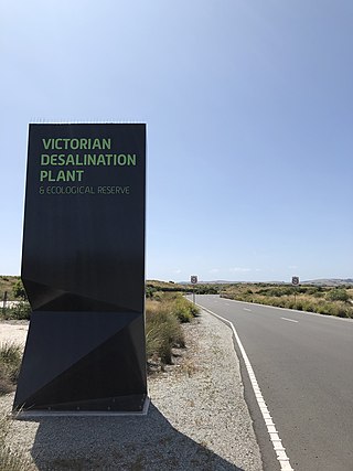
The Victorian Desalination Plant is a water desalination plant in Dalyston, on the Bass Coast in southern Victoria, Australia. The project was announced by Premier Steve Bracks in June 2007, at the height of the millennium drought when Melbourne's water storage levels dropped to 28.4%, a drop of more than 20% from the previous year. Increased winter-spring rains after mid-2007 took water storage levels above 40%, but it was not until 2011 that storages returned to pre-2006 levels.

Peak water is a concept that underlines the growing constraints on the availability, quality, and use of freshwater resources. Peak water was defined in 2010 by Peter Gleick and Meena Palaniappan. They distinguish between peak renewable, peak non-renewable, and peak ecological water to demonstrate the fact that although there is a vast amount of water on the planet, sustainably managed water is becoming scarce.

Water resources management is a significant challenge for Mexico. The country has in place a system of water resources management that includes both central (federal) and decentralized institutions. Furthermore, water management is imposing a heavy cost to the economy.

Water supply and sanitation in Israel are intricately linked to the historical development of Israel. Because rain falls only in the winter, and largely in the northern part of the country, irrigation and water engineering are considered vital to the country's economic survival and growth. Large scale projects to desalinate seawater, direct water from rivers and reservoirs in the north, make optimal use of groundwater, and reclaim flood overflow and sewage have been undertaken. Among them is the National Water Carrier, carrying water from the country's biggest freshwater lake, the Sea of Galilee, to the northern part of the Negev desert through channels, pipes and tunnels. Israel's water demand today outstrips available conventional water resources. Thus, in an average year, Israel relies for about half of its water supply on unconventional water resources, including reclaimed water and desalination. A particularly long drought in 1998–2002 had prompted the government to promote large-scale seawater desalination. In 2022, 85% of the country's drinkable water was produced through desalination of saltwater and brackish water.

<span class="mw-page-title-main">Water in California</span> Water supply and distribution in the U.S. state of California

California's interconnected water system serves over 30 million people and irrigates over 5,680,000 acres (2,300,000 ha) of farmland. As the world's largest, most productive, and potentially most controversial water system, it manages over 40 million acre-feet (49 km3) of water per year.

As Australia's supply of freshwater is increasingly vulnerable to droughts, possibly as a result of climate change, there is an emphasis on water conservation and various regions have imposed restrictions on the use of water.

<span class="mw-page-title-main">Mokelumne Aqueduct</span> Bridge

The Mokelumne Aqueduct is a 95-mile (153 km) water conveyance system in central California, United States. The aqueduct is supplied by the Mokelumne River and provides water to 35 municipalities in the East Bay in the San Francisco Bay Area. The aqueduct and the associated dams, pipelines, treatment plants and hydroelectric system are owned and operated by the East Bay Municipal Utility District (EBMUD) and provide over 90 percent of the water used by the agency.

<span class="mw-page-title-main">Calero Reservoir</span> Reservoir in Santa Clara County, California

Calero Reservoir, also called Calero Lake, is a reservoir in San Jose, California, located in the Calero neighborhood of Almaden Valley in South San Jose. It is the site of Calero County Park, which also includes a large area covering the lake and hundreds of acres of hills around it.

<span class="mw-page-title-main">Monterey Peninsula</span> Peninsula in California, USA

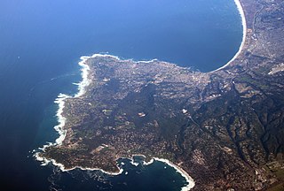
The Monterey Peninsula anchors the northern portion on the Central Coast of California and comprises the cities of Monterey, Carmel, and Pacific Grove, and the resort and community of Pebble Beach.

The Minjur Desalination Plant is a reverse osmosis, water desalination plant at Kattupalli village, a northern suburb of Chennai, India, on the coast of the Bay of Bengal that supplies water to the city of Chennai. Built on a 60-acre site, it is the largest desalination plant in India. Construction works were carried out by the Indian company IVRCL and the Spanish company Abengoa, under the direction of the Project Manager Fernando Portillo Vallés and the Construction Manager Juan Ignacio Jiménez-Velasco, who returned to Europe after the inauguration of the plant to work on renewable energy projects. Originally scheduled to be operational by January 2009, the work on the plant was delayed due to Cyclone Nisha in October 2008, which damaged a portion of the completed marine works and destroyed the cofferdam meant for the installation of transition pipes. The trial runs were completed in June 2010 and the plant was opened in July 2010. Water from the plant will be utilised chiefly for industrial purposes such as the Ennore Port and North Chennai Thermal Power Station. However, during droughts, water from the plant will be supplied to the public, serving an estimated population of 1,000,000.

<span class="mw-page-title-main">Nacimiento Dam</span> Dam in San Luis Obispo County, California

Nacimiento Dam is a dam on the Nacimiento River about 10 miles (16 km) northwest of Paso Robles, California in the United States. The primary purpose of the dam is to provide groundwater recharge for agriculture in Monterey County and northern San Luis Obispo County supported by the Salinas Valley aquifer, as well as flood control, domestic water supply, and hydropower. It forms Lake Nacimiento, popular for boating, fishing and camping, and known locally as the "Dragon Lake" due to its shape.

The coastal city of Chennai has a metropolitan population of 10.6 million as per 2019 census. As the city lacks a perennial water source, catering the water requirements of the population has remained an arduous task. On 18 June 2019, the city's reservoirs ran dry, leaving the city in severe crisis.

<span class="mw-page-title-main">Water reuse in California</span>

Water reuse in California is the use of reclaimed water for beneficial use. As a heavily populated state in the drought-prone arid west, water reuse is developing as an integral part of water in California enabling both the economy and population to grow.

<span class="mw-page-title-main">Big Sur Land Trust</span> Non-profit located in Monterey, California

The Big Sur Land Trust is a private 501(c)(3) non-profit located in Monterey, California, that has played an instrumental role in preserving land in California's Big Sur and Central Coast regions. The trust was the first to conceive of and use the "conservation buyer" method in 1989 by partnering with government and developers to offer tax benefits as an inducement to sell land at below-market rates. Since 1978, with the support of donors, funders and partners, it has conserved over 40,000 acres through conservation easements, acquisition and transfer of land to state, county and city agencies. It has placed conservation easements on 7,000 acres and has retained ownership of over 4,000 acres.

Borrego Valley Groundwater Basin, located in the very southern region of California, is one of the driest basins in the state. With climate change predicted to have strong effects into foreseeable future, the region is viewed with a skepticism in the sustainable use of water at current rates of consumption. Both natural and man-made geographic divisions within this basin allow for a closer inspection of the various management techniques implemented throughout the years, and provide a basis for what may be pursued for an uncertain future.

References

  1. 1 2 3 4 5 6 7 "CalAM Monterey Peninsula Water Project DEIR Review". CI Marina.
  2. 1 2 3 4 5 6 "Water Supply Project".
  3. 1 2 3 4 5 6 7 8 9 10 11 12 13 14 15 "mpwsp". mpwsp. Retrieved 2016-04-02.
  4. 1 2 3 "2016 Monterey Peninsula Water Conservation Conservation and Rationing Plan" (PDF). mpwmd.
  5. 1 2 "California American Water". amwater. Archived from the original on 2016-07-01.