Montpelier, Idaho

Last updated

Montpelier, Idaho
Montpelier Idaha 072417.jpg
Montpelier, Idaho, downtown view.
Bear Lake County Idaho Incorporated and Unincorporated areas Montpelier Highlighted 1653920.svg
Location of Montpelier in Bear Lake County, Idaho.
Coordinates: 42°19′13″N111°18′13″W / 42.32028°N 111.30361°W / 42.32028; -111.30361
Country United States
State Idaho
County Bear Lake
Named for Montpelier, Vermont
Government
  Type Mayor–council [1]
   Mayor Ted Slivinski [2]
Area
[3]
  Total2.32 sq mi (6.00 km2)
  Land2.32 sq mi (6.00 km2)
  Water0.00 sq mi (0.00 km2)
Elevation
5,981 ft (1,823 m)
Population
 (2010) [4]
  Total2,597
  Estimate 
(2019) [5]
2,538
  Density1,094.91/sq mi (422.70/km2)
Time zone UTC-7 (Mountain (MST))
  Summer (DST) UTC-6 (MDT)
ZIP codes
83220, 83254
Area code(s) 208, 986
FIPS code 16-53920
GNIS feature ID0396914
Website montpelier.id.gov

Montpelier is a city in Bear Lake County, Idaho, United States. The population was 2,538 at the 2019 estimation, down from 2,597 in 2010 census. The city is the largest community in the Bear Lake Valley, a farming region north of Bear Lake in southeastern Idaho along the Utah border. It was settled in 1863 by Mormon pioneers on the route of the Oregon Trail. Nearby to the east is the border with Wyoming.

Contents

History

As happened for many western towns, the name has been changed numerous times. First it was known as Clover Creek by Oregon Trail travelers, later it became Belmont and finally was given the name Montpelier by Brigham Young, one of the early leaders of the Church of Jesus Christ of Latter-day Saints (LDS Church), after the capital of his birth state of Vermont. The city was first settled in 1864. [6]

The Oregon Short Line Railway started in Granger, Wyoming from the existing Union Pacific station, and reached Montpelier on August 5, 1882 (the rail line reached Huntington, Oregon in 1884). The terminal was located here until 1972. The railroad brought a population that made Montpelier the county's "Gentile Town" as opposed to nearby Mormon-run Paris that was the county seat. Both cities would have tabernacles built in their city limits.

U.S. Routes 89 and 30 intersect in Montpelier.

On August 13, 1896, the Bank of Montpelier was the site of a heist by Butch Cassidy and members of Butch Cassidy's Wild Bunch, Elzy Lay and Henry "Bub" Meeks, who were supposedly trying to get enough money to bail out fellow gang member Matt Warner. [7] They escaped with roughly $7,000. This historical footnote has become a notable component of the town's identity and is commemorated by a plaque on Washington Street (Highway 89).

On 3 April 2022, LDS Prophet Russell M. Nelson announced that an LDS Temple would be built in Montpelier. [8]

Arts and culture

The National Oregon/California Trail Center in Montpelier is an interactive interpretive center dedicated to the history of the trails that ran through the town. [9]

The National Oregon/California Trail Center, 320 North 4th Street, Montpelier, ID A-4. The National OregonCalifornia Trail Center at Clover Creek (320 North 4th Street, Montpelier, ID) on the California and Oregon National Historic Trails (2007) (acbb44b8-71ae-46d7-aae2-74ef34fdea42).JPG
The National Oregon/California Trail Center, 320 North 4th Street, Montpelier, ID

The Butch Cassidy Museum at the Bank of Montpelier is located in a bank built in 1891 which contains the original vault. [10] It is the only bank robbed by Butch Cassidy that continues to stand. [11]

The 4.9 acres (2.0 ha) Montpelier Historic District is listed on the National Register of Historic Places. [12] It includes four buildings: the city hall, a high school, the high school's gymnasium, and the Church of Jesus Christ of Latter-Day Saints' Stake Tabernacle. Also listed in the register are the John A. Bagley House, Montpelier Odd Fellows Hall, and the Montpelier Carnegie Library.

Geography

Montpelier is located at 42°19′13″N111°18′13″W / 42.32028°N 111.30361°W / 42.32028; -111.30361 (42.320416, -111.303703), [13] at an elevation of 5,981 feet (1,823 m) above sea level.

According to the United States Census Bureau, the city has a total area of 2.33 square miles (6.03 km2), all of it land. [14]

Climate

According to the Köppen climate classification, Montpelier has a warm-summer humid continental climate (Köppen climate classification: Dfb).

Climate data for Montpelier, Idaho, 1991–2020 simulated normals (5951 ft elevation)
MonthJanFebMarAprMayJunJulAugSepOctNovDecYear
Mean daily maximum °F (°C)29.7
(−1.3)
32.5
(0.3)
42.1
(5.6)
52.5
(11.4)
62.8
(17.1)
73.2
(22.9)
83.5
(28.6)
82.6
(28.1)
72.5
(22.5)
58.1
(14.5)
42.4
(5.8)
30.9
(−0.6)
55.2
(12.9)
Daily mean °F (°C)18.5
(−7.5)
20.5
(−6.4)
30.2
(−1.0)
39.7
(4.3)
48.9
(9.4)
57.4
(14.1)
65.5
(18.6)
64.2
(17.9)
54.7
(12.6)
43.0
(6.1)
30.6
(−0.8)
20.1
(−6.6)
41.1
(5.1)
Mean daily minimum °F (°C)7.3
(−13.7)
8.4
(−13.1)
18.3
(−7.6)
27.0
(−2.8)
35.1
(1.7)
41.5
(5.3)
47.3
(8.5)
45.9
(7.7)
36.9
(2.7)
27.7
(−2.4)
18.9
(−7.3)
9.5
(−12.5)
27.0
(−2.8)
Average precipitation inches (mm)1.56
(39.55)
1.51
(38.37)
1.37
(34.75)
1.55
(39.26)
1.95
(49.52)
1.20
(30.60)
0.66
(16.82)
0.76
(19.20)
1.23
(31.27)
1.27
(32.37)
1.20
(30.59)
1.38
(35.01)
15.64
(397.31)
Average dew point °F (°C)11.5
(−11.4)
13.1
(−10.5)
19.9
(−6.7)
25.2
(−3.8)
32.4
(0.2)
37.4
(3.0)
40.8
(4.9)
38.8
(3.8)
32.2
(0.1)
25.7
(−3.5)
19.2
(−7.1)
13.1
(−10.5)
25.8
(−3.5)
Source: Prism Climate Group [15]

Demographics

Historical population
CensusPop.Note
1870 120
1880 546355.0%
1890 1,174115.0%
1900 1,44423.0%
1910 1,92433.2%
1920 2,98455.1%
1930 2,436−18.4%
1940 2,82415.9%
1950 2,682−5.0%
1960 3,14617.3%
1970 2,604−17.2%
1980 3,10719.3%
1990 2,656−14.5%
2000 2,7854.9%
2010 2,597−6.8%
2019 (est.)2,538 [5] −2.3%
U.S. Decennial Census [16]

2010 census

As of the census [4] of 2010, there were 2,597 people, 1,006 households, and 680 families living in the city. The population density was 1,114.6 inhabitants per square mile (430.3/km2). There were 1,234 housing units at an average density of 529.6 per square mile (204.5/km2). The racial makeup of the city was 96.2% White, 0.4% Native American, 0.2% Asian, 2.0% from other races, and 1.2% from two or more races. Hispanic or Latino of any race were 4.9% of the population.

There were 1,006 households, of which 35.0% had children under the age of 18 living with them, 55.6% were married couples living together, 8.1% had a female householder with no husband present, 4.0% had a male householder with no wife present, and 32.4% were non-families. 28.5% of all households were made up of individuals, and 13.1% had someone living alone who was 65 years of age or older. The average household size was 2.55 and the average family size was 3.17.

The median age in the city was 36.4 years. 29.1% of residents were under the age of 18; 6.5% were between the ages of 18 and 24; 23.4% were from 25 to 44; 23.9% were from 45 to 64; and 17.1% were 65 years of age or older. The gender makeup of the city was 48.2% male and 51.8% female.

2000 census

As of the census [17] of 2000, there were 2,785 people, 1,012 households, and 715 families living in the city. The population density was 1,512.3 inhabitants per square mile (583.9/km2). There were 1,171 housing units at an average density of 635.9 per square mile (245.5/km2). The racial makeup of the city was 96.70% White, 0.61% Native American, 0.04% Pacific Islander, 1.97% from other races, and 0.68% from two or more races. Hispanic or Latino of any race were 3.81% of the population.

There were 1,012 households, out of which 38.4% had children under the age of 18 living with them, 58.7% were married couples living together, 8.8% had a female householder with no husband present, and 29.3% were non-families. 26.6% of all households were made up of individuals, and 13.9% had someone living alone who was 65 years of age or older. The average household size was 2.70 and the average family size was 3.31.

In the city, the population was spread out, with 32.3% under the age of 18, 8.3% from 18 to 24, 23.6% from 25 to 44, 19.4% from 45 to 64, and 16.6% who were 65 years of age or older. The median age was 34 years. For every 100 females, there were 96.3 males. For every 100 females age 18 and over, there were 93.4 males.

The median income for a household in the city was $29,693, and the median income for a family was $33,639. Males had a median income of $32,218 versus $15,227 for females. The per capita income for the city was $12,364. About 9.2% of families and 12.9% of the population were below the poverty line, including 17.6% of those under age 18 and 9.2% of those age 65 or over.

Related Research Articles

<span class="mw-page-title-main">Gooding County, Idaho</span> County in Idaho, United States

Gooding County is a county located in the U.S. state of Idaho. As of the 2020 census, the population was 15,598. Its county seat is Gooding. The county was created by the Idaho Legislature on January 28, 1913, by a partition of Lincoln County. It is named for Frank R. Gooding, the 7th governor and a United States Senator from Idaho.

<span class="mw-page-title-main">Bear Lake County, Idaho</span> County in Idaho, United States

Bear Lake County is a county in the U.S. state of Idaho. As of the 2020 United States Census the county had a population of 6,372. The county seat is Paris, and Montpelier is the largest city.

<span class="mw-page-title-main">Lava Hot Springs, Idaho</span> City in Bannock County, Idaho, United States

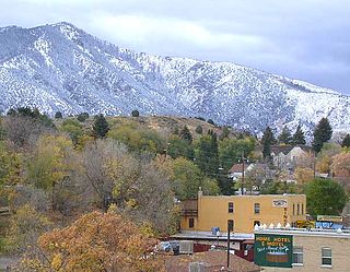
Lava Hot Springs is a city along the Portneuf River in eastern Bannock County, Idaho, United States. It is part of the Pocatello, Idaho metropolitan area. The population was 407 at the 2010 census, down from 521 in 2000. Located in the mountainous valley of the Portneuf River on the old route of the Oregon Trail and California Trail, the city has become a popular resort location, noted for its numerous hot springs amenable to bathing and a turbulent inner tube run through part of the town.

<span class="mw-page-title-main">McCammon, Idaho</span> City in Idaho, United States

McCammon is a city in Bannock County, Idaho, United States. It is part of the Pocatello, Idaho Metropolitan Statistical Area'. The population was 809 at the 2010 census. In 1892, McCammon became the junction point between the Oregon Short Line Railroad and Utah and Northern Railway, and city gained the nickname Junction City.

<span class="mw-page-title-main">Georgetown, Idaho</span> City in Idaho, United States

Georgetown is a city in the Bear River Valley in Bear Lake County, Idaho, United States, at the center of a farming area between the river and the mountains to the east. It was settled by Mormon pioneers on the route of the Oregon Trail and was named after George Q. Cannon. Georgetown was first settled in 1864 The population was 476 at the 2010 census. U.S. Route 30 passes through the town.

<span class="mw-page-title-main">Paris, Idaho</span> City in Idaho, United States

Paris is a city and county seat of Bear Lake County, Idaho, United States. Located on the western side of the Bear Lake Valley, the city's population was 513 at the 2010 census, down from 576 in 2000. Paris was settled on September 26, 1863, by pioneer settlers of the Church of Jesus Christ of Latter-day Saints.

<span class="mw-page-title-main">Plummer, Idaho</span> City in Idaho, United States

Plummer is a city in Benewah County, Idaho, United States. The population was 1,044 at the 2010 census, up from 990 in 2000. It is the largest city within the Coeur d'Alene Reservation, and is accessed by U.S. Route 95, the state's primary north–south highway.

<span class="mw-page-title-main">Shelley, Idaho</span> City in Bingham County, Idaho, United States

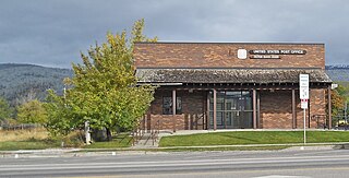
Shelley is a city in Bingham County, Idaho, United States. The population was 4,409 at the 2010 census.

<span class="mw-page-title-main">Caldwell, Idaho</span> City in Idaho, United States

Caldwell is a city in and the county seat of Canyon County, Idaho. The population was 59,996 at the time of the 2020 United States census, making it the 5th most populous city in Idaho.

<span class="mw-page-title-main">Soda Springs, Idaho</span> City in the United States

Soda Springs is a city in Caribou County, Idaho, United States. Its population was 3,133 at the time of the 2020 census. The city has been the county seat of Caribou County since the county was organized in 1919. In the 1860s, Soda Springs served as the seat of Oneida County.

<span class="mw-page-title-main">Glenns Ferry, Idaho</span> City in Idaho, United States

Glenns Ferry is a city in Elmore County, Idaho, United States. The population was 1,293 at the 2020 census. The city is adjacent to Interstate 84 and the Snake River.

<span class="mw-page-title-main">Fruitland, Idaho</span> City in Payette County, Idaho, United States

Fruitland is a city along the Snake and Payette rivers in Payette County, Idaho, United States. It lies along U.S. Route 95 in the Treasure Valley of southwest Idaho, about 50 miles (80 km) west of Boise on the border with Oregon. It is part of the Ontario Micropolitan Area. Fruitland is named after apple orchards that surround the community, and its slogan is "The Big Apple of Idaho."

<span class="mw-page-title-main">Victor, Idaho</span> City in Idaho, United States

Victor is the largest city in Teton County, Idaho, United States. The population was 2,157 at the 2020 census, up from 1,928 in 2010, and 840 from 2000. It is part of the Jackson, WY–ID Micropolitan Statistical Area.

<span class="mw-page-title-main">Buhl, Idaho</span> City in Twin Falls, Idaho, United States

Buhl is a city located on the old Oregon Trail in the western half of Twin Falls County, Idaho. The population was 4,122 at the time of the 2010 census, up from 3,985 in 2000. It is part of the Twin Falls, Idaho metropolitan area.

<span class="mw-page-title-main">Alvord, Iowa</span> City in Iowa, United States

Alvord is a city in Lyon County, Iowa, United States. The population was 206 at the 2020 census.

<span class="mw-page-title-main">Gardner, Kansas</span> City in Kansas, United States

Gardner is a city in Johnson County, Kansas, United States. As of the 2020 census, the population of the city was 23,287. It is located within the Kansas City metropolitan area.

<span class="mw-page-title-main">Montpelier, Ohio</span> Village in Ohio, United States

Montpelier is a village in Williams County, Ohio, United States. The population was 3,942 at the 2020 census.

<span class="mw-page-title-main">Richland, Oregon</span> City in Oregon, United States

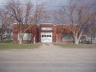
Richland is a city in Baker County, Oregon, United States. The population was 156 at the 2010 census.

<span class="mw-page-title-main">Banks, Oregon</span> City in Oregon, United States

Banks is a city in Washington County, Oregon, United States which is located in the Tualatin Valley. It is the southern anchor to the Banks–Vernonia State Trail, which is a 21-mile (34 km) long linear trail popular with bicyclists, hikers, and equestrians. The population was 1,777 at the 2010 census. The community was named for John and Nancy Banks, who owned a nearby dairy farm. Incorporated in 1921, it is located in the western part of the county where Oregon Route 6 intersects Oregon Route 47.

<span class="mw-page-title-main">Circleville, Utah</span> Town in the state of Utah, United States

Circleville is a town in Piute County, Utah, United States. The population was 547 at the 2010 census.

References

  1. "City Government - Montpelier, Idaho". montpelier.id.gov. Retrieved January 4, 2020.
  2. "Mayor and Council - Montpelier, Idaho". montpelier.id.gov. Retrieved January 4, 2020.
  3. "2019 U.S. Gazetteer Files". United States Census Bureau. Retrieved July 9, 2020.
  4. 1 2 "U.S. Census website". United States Census Bureau . Retrieved December 18, 2012.
  5. 1 2 "Population and Housing Unit Estimates". United States Census Bureau. May 24, 2020. Retrieved May 27, 2020.
  6. Leonard J. Arrington. History of Idaho. Vol. 1, p. 273
  7. Idaho State Historical Society: Public Archives and Research Library, inmate files: Henry "Bob" Meeks, #574.
  8. Toone, Trent (April 3, 2022). "17 new temple locations announced by President Nelson to close conference". Deseret News. Retrieved April 3, 2022.
  9. "The National Oregon/California Trail Center (U.S. National Park Service)". www.nps.gov. Retrieved December 3, 2023.
  10. "Small Town Spotlight: Montpelier museum honors Butch Cassidy inside a building he once robbed". East Idaho News. July 26, 2022. Retrieved December 3, 2023.
  11. "Butch Cassidy Museum at the Bank of Montpelier | Visit Idaho" . Retrieved December 3, 2023.
  12. "National Register Database and Research - National Register of Historic Places (U.S. National Park Service)". www.nps.gov. Retrieved December 3, 2023.
  13. "US Gazetteer files: 2010, 2000, and 1990". United States Census Bureau. February 12, 2011. Retrieved April 23, 2011.
  14. "US Gazetteer files 2010". United States Census Bureau. Archived from the original on July 2, 2012. Retrieved December 18, 2012.
  15. "PRISM Climate Group at Oregon State University". Northwest Alliance for Computational Science & Engineering (NACSE), based at Oregon State University. Retrieved March 13, 2023.
  16. "Census of Population and Housing". Census.gov. Retrieved June 4, 2015.
  17. "U.S. Census website". United States Census Bureau . Retrieved January 31, 2008.