Montpelier, North Dakota

Last updated

Montpelier, North Dakota
Montpelier, North Dakota 6-8-2008.jpg
Business district of Montpelier
ND Stutsman County Montpelier.svg
Location of Montpelier, North Dakota
Coordinates: 46°41′56″N98°35′18″W / 46.69889°N 98.58833°W / 46.69889; -98.58833
CountryUnited States
State North Dakota
County Stutsman
Founded1885
Area
[1]
  Total0.15 sq mi (0.40 km2)
  Land0.15 sq mi (0.40 km2)
  Water0.00 sq mi (0.00 km2)
Elevation
[2]
1,375 ft (419 m)
Population
 (2020) [3]
  Total85
  Estimate 
(2022) [4]
86
  Density555.56/sq mi (214.77/km2)
Time zone UTC-6 (Central (CST))
  Summer (DST) UTC-5 (CDT)
ZIP code
58472
Area code 701
FIPS code 38-53980
GNIS feature ID1036169 [2]

Montpelier is a city in Stutsman County, North Dakota, United States. The population was 85 at the 2020 census. [3] Montpelier was founded in 1885.

Contents

Geography

According to the United States Census Bureau, the city has a total area of 0.18 square miles (0.47 km2), all land. [5]

Demographics

Historical population
CensusPop.Note
1920 186
1930 165−11.3%
1940 133−19.4%
1950 105−21.1%
1960 97−7.6%
1970 11619.6%
1980 96−17.2%
1990 82−14.6%
2000 10325.6%
2010 87−15.5%
2020 85−2.3%
2022 (est.)86 [4] 1.2%
U.S. Decennial Census [6]
2020 Census [3]

2010 census

As of the census of 2010, there were 87 people, 39 households, and 28 families residing in the city. The population density was 483.3 inhabitants per square mile (186.6/km2). There were 46 housing units at an average density of 255.6 per square mile (98.7/km2). The racial makeup of the city was 100.0% White.

There were 39 households, of which 25.6% had children under the age of 18 living with them, 59.0% were married couples living together, 10.3% had a female householder with no husband present, 2.6% had a male householder with no wife present, and 28.2% were non-families. 25.6% of all households were made up of individuals, and 5.2% had someone living alone who was 65 years of age or older. The average household size was 2.23 and the average family size was 2.64.

The median age in the city was 44.8 years. 21.8% of residents were under the age of 18; 5.7% were between the ages of 18 and 24; 22.9% were from 25 to 44; 31% were from 45 to 64; and 18.4% were 65 years of age or older. The gender makeup of the city was 50.6% male and 49.4% female.

2000 census

As of the census of 2000, there were 103 people, 44 households, and 31 families residing in the town. The population density was 385.9 inhabitants per square mile (149.0/km2). There were 45 housing units at an average density of 168.6 per square mile (65.1/km2). The racial makeup of the town was 99.03% White and 0.97% African American.

There were 44 households, out of which 29.5% had children under the age of 18 living with them, 54.5% were married couples living together, 13.6% had a female householder with no husband present, and 29.5% were non-families. 22.7% of all households were made up of individuals, and 9.1% had someone living alone who was 65 years of age or older. The average household size was 2.34 and the average family size was 2.77.

In the town the population was spread out, with 23.3% under the age of 18, 4.9% from 18 to 24, 28.2% from 25 to 44, 31.1% from 45 to 64, and 12.6% who were 65 years of age or older. The median age was 42 years. For every 100 females, there were 119.1 males. For every 100 females age 18 and over, there were 107.9 males.

The median income for a household in the town was $26,250, and the median income for a family was $36,250. Males had a median income of $22,083 versus $20,500 for females. The per capita income for the town was $15,619. There were no families and 6.0% of the population living below the poverty line, including no under eighteens and 17.4% of those over 64.

Climate

This climatic region is typified by large seasonal temperature differences, with warm to hot (and often humid) summers and cold (sometimes severely cold) winters. According to the Köppen Climate Classification system, Montpelier has a humid continental climate, abbreviated "Dfb" on climate maps. [7]

Related Research Articles

<span class="mw-page-title-main">Chatom, Alabama</span> City in and county seat of Washington County, Alabama

Chatom is a town in Washington County, Alabama, United States. It incorporated in 1949. Chatom is the county seat of Washington County, holding the distinction since 1907. The town's population was 1,288 At the 2010 census, up from 1,193 in 2000.

<span class="mw-page-title-main">Montpelier, Idaho</span> City in Idaho, United States

Montpelier is a city in Bear Lake County, Idaho, United States. The population was 2,538 at the 2019 estimation, down from 2,597 in 2010 census. The city is the largest community in the Bear Lake Valley, a farming region north of Bear Lake in southeastern Idaho along the Utah border. It was settled in 1863 by Mormon pioneers on the route of the Oregon Trail. Nearby to the east is the border with Wyoming.

<span class="mw-page-title-main">Paris, Idaho</span> City in Idaho, United States

Paris is a city and county seat of Bear Lake County, Idaho, United States. Located on the western side of the Bear Lake Valley, the city's population was 513 at the 2010 census, down from 576 in 2000. Paris was settled on September 26, 1863, by pioneer settlers of the Church of Jesus Christ of Latter-day Saints.

<span class="mw-page-title-main">Masardis, Maine</span> Town in Maine, United States

Masardis is a town in Aroostook County, Maine, United States. The population was 204 at the 2020 census.

<span class="mw-page-title-main">New Limerick, Maine</span> Town in the state of Maine, United States

New Limerick is a town in Aroostook County, Maine, United States. The population was 574 at the 2020 census. The town was settled in 1775 and incorporated on March 18, 1837 from New Limerick Plantation. It received its name from the fact that many of its settlers had previously lived in Limerick in York County at the southern end of the state, which in turn was probably named after the Irish city of Limerick.

<span class="mw-page-title-main">New Sharon, Maine</span> Town in the state of Maine, United States

New Sharon is a town in Franklin County, Maine, incorporated in 1794. The population was 1,458 at the 2020 census. The town is roughly bisected by the Sandy River, a tributary of the Kennebec River.

<span class="mw-page-title-main">Hartford, Maine</span> Town in the state of Maine, United States

Hartford is a town in Oxford County, Maine, United States. Hartford is included in the Lewiston-Auburn, Maine metropolitan New England City and Town Area. The population was 1,203 at the 2020 census.

Danforth is a town in Washington County, Maine, United States. The town was named for proprietor Thomas Danforth. The population was 587 at the 2020 census. The town contains the villages of Danforth and Eaton. East Grand High School is located in Danforth.

Jonesboro is a town in Washington County, Maine, United States. The town was named for John Coffin Jones, a landholder. The population was 587 at the 2020 census.

Topsfield is a town in Washington County, Maine, United States. The population was 179 at the 2020 census.

Wesley is a town in Washington County, Maine, United States. The town was named after John Wesley, founder of the English Methodist movement. The population was 122 at the 2020 census.

<span class="mw-page-title-main">Morristown, Vermont</span> Town in Vermont, United States

Morristown is a town in Lamoille County, Vermont, United States. As of the 2020 census, the population was 5,434. Morristown is the largest town by population in Lamoille County, and its central village of Morrisville serves as the county's main commercial center.

<span class="mw-page-title-main">Man, West Virginia</span> Town in West Virginia, United States

Man is a town in Logan County, West Virginia, United States. The population was 772 at the 2020 census. The town is located along the Guyandotte River at the mouth of Buffalo Creek, which was the site of the 1972 Buffalo Creek Flood following a dam collapse. The name of the town reportedly derives from the last syllable of the surname of Ulysses Hinchman, who was a member of the House of Delegates from Logan County between 1866 and 1869.

<span class="mw-page-title-main">Iaeger, West Virginia</span> Town in West Virginia, United States

Iaeger is a town in McDowell County, West Virginia, United States. The population was 257 at the 2020 census.

<span class="mw-page-title-main">Granville, West Virginia</span> Town in West Virginia

Granville is a town in Monongalia County, West Virginia, United States. The population was 1,355 at the 2020 census. It is included in the Morgantown metropolitan area.

<span class="mw-page-title-main">Albright, West Virginia</span> Town in West Virginia, United States

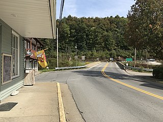
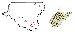
Albright is a town in central Preston County, West Virginia, United States, along the Cheat River. The population was 260 at the 2020 census. A former coal town, it is part of the Morgantown metropolitan area.

<span class="mw-page-title-main">Bruceton Mills, West Virginia</span> Town in West Virginia, United States

Bruceton Mills is a town in northern Preston County, West Virginia, United States, along Big Sandy Creek. The population was 64 at the 2020 census, making it the second-least populous town in West Virginia, after Thurmond. It is part of the Morgantown metropolitan area.

<span class="mw-page-title-main">Cairo, West Virginia</span> Town in West Virginia, United States

Cairo is a town in Ritchie County, West Virginia, United States, along West Virginia Route 31, the North Fork of the Hughes River, and the North Bend Rail Trail. The population was 174 at the 2020 census.

<span class="mw-page-title-main">Hambleton, West Virginia</span> Town in West Virginia, United States

Hambleton is a town in Tucker County, West Virginia, United States. The population was 216 at the 2020 census. Hambleton was established in 1889, but not incorporated until 1905. It was named by then United States Senator Stephen B. Elkins in honor of a stockholder by this name in the West Virginia Central Railroad Company. The town was previously known as Hulings.

<span class="mw-page-title-main">Smithfield, West Virginia</span> Town in West Virginia, United States

Smithfield is a town in Wetzel County, West Virginia, United States. The population was 103 at the 2020 census.

References

  1. "ArcGIS REST Services Directory". United States Census Bureau. Retrieved September 20, 2022.
  2. 1 2 U.S. Geological Survey Geographic Names Information System: Montpelier, North Dakota
  3. 1 2 3 "Explore Census Data". United States Census Bureau . Retrieved December 14, 2023.
  4. 1 2 "City and Town Population Totals: 2020-2022". United States Census Bureau. December 14, 2023. Retrieved December 14, 2023.
  5. "US Gazetteer files 2010". United States Census Bureau. Archived from the original on July 2, 2012. Retrieved June 14, 2012.
  6. United States Census Bureau. "Census of Population and Housing" . Retrieved October 31, 2013.
  7. Climate Summary for Montpelier, North Dakota