The Aurelian Walls are a line of city walls built between 271 AD and 275 AD in Rome, Italy, during the reign of the Roman Emperor Aurelian. They superseded the earlier Servian Wall built during the 4th century BC.

The Victor Emmanuel II National Monument, also known as the Vittoriano or Altare della Patria, is a large national monument built between 1885 and 1935 to honour Victor Emmanuel II, the first king of a unified Italy, in Rome, Italy. It occupies a site between the Piazza Venezia and the Capitoline Hill. The monument was realized by Giuseppe Sacconi.

Sallustiano is the 17th rione of Rome, Italy, identified by the initials R. XVII. It is located within the Municipio I and the name refers to the ancient Gardens of Sallust, which were located here.

Castro Pretorio is the 18th rione of Rome, Italy, identified by the initials R. XVIII, and it is located within the Municipio I. The rione takes its name by the ruins of the Castrum Praetorium, the barracks of the Praetorian Guard, included in the Aurelian Walls.

The Parish Basilica of Santa Maria del Popolo is a titular church and a minor basilica in Rome run by the Augustinian order. It stands on the north side of Piazza del Popolo, one of the most famous squares in the city. The church is hemmed in between the Pincian Hill and Porta del Popolo, one of the gates in the Aurelian Wall as well as the starting point of Via Flaminia, the most important route from the north. Its location made the basilica the first church for the majority of travellers entering the city. The church contains works by several famous artists, such as Raphael, Gian Lorenzo Bernini, Caravaggio, Alessandro Algardi, Pinturicchio, Andrea Bregno, Guillaume de Marcillat and Donato Bramante.

The Arch of Trajan is an ancient Roman triumphal arch in Benevento, southern Italy. It was erected in honour of the Emperor Trajan across the Via Appia, at the point where it enters the city.

The Porta del Popolo, or Porta Flaminia, is a city gate of the Aurelian Walls of Rome that marks the border between Piazza del Popolo and Piazzale Flaminio.

The Porta San Sebastiano is the largest and one of the best-preserved gates passing through the Aurelian Walls in Rome (Italy).

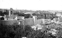
Porta Pia was one of the northern gates in the Aurelian Walls of Rome, Italy. One of Pope Pius IV's civic improvements to the city, it is named after him. Situated at the end of a new street, the Via Pia, it was designed by Michelangelo to replace the Porta Nomentana situated several hundred meters southwards, which was closed up at the same time. Construction began in 1561 and ended in 1565, after the artist's death. A 1561 bronze commemorative medal by Gian Federico Bonzagna shows an early plan by Michelangelo, very different from his final design. The façade on the outside of the city was completed in 1869 under the Neo-Classicist design by Virginio Vespignani.
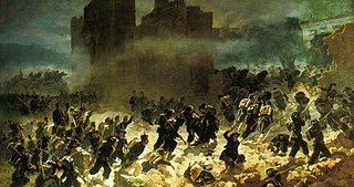
The Capture of Rome on September 20, 1870, was the final event of the unification of Italy (Risorgimento), marking both the final defeat of the Papal States under Pope Pius IX and the unification of most of the Italian Peninsula under the Kingdom of Italy, a constitutional monarchy.

Porta Salaria was a gate in the Aurelian Walls of Rome, Italy. Constructed between 271 AD and 275 AD, it was demolished in 1921.

The Porta Nomentana was one of the gates in the Aurelian Walls of Rome, Italy. It is located along viale del Policlinico, around 70 m east of Porta Pia. It is now blocked and merely a boundary wall for the British Embassy.
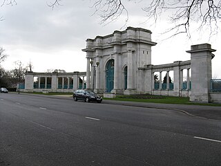
The City War Memorial, Nottingham, also known as the Nottingham Municipal War Memorial and the City of Nottingham War Memorial, is the main war memorial for the city of Nottingham in England. It comprises a memorial arch of Portland stone with three openings and wrought iron gates, and stone flanking arcades. It was unveiled in 1927 beside a new park overlooking the River Trent, and became a Grade II listed building in 1972.

The Janiculum walls are a stretch of defensive walls erected in 1643 by Pope Urban VIII as a completion of the Leonine wall and for a better protection of the area of Rome rising on the right bank of the Tiber.

The Baths of Nero or Baths of Alexander were a complex of ancient Roman baths on the Campus Martius in Rome, built by Nero in either 62 or 64 and rebuilt by Alexander Severus in 227 or 229. It stood between the Pantheon and the Stadium of Domitian and were listed among the most notable buildings in the city by Roman authors and became a much-frequented venue. These thermae were the second large public baths built in Rome, after the Baths of Agrippa, and it was probably the first "imperial-type" complex of baths, with a monumental scale and symmetrical, axially-planned design. While in the sixteenth century the foundations of the caldarium were still visible, nothing else of the structure remains above ground except some fragments of walls incorporated into the structure of Palazzo Madama.

Hermann Kanzler was a German general who commanded the Army of the Papal States and was the arms minister during the reign of Pope Pius IX. He led Papal forces during the Battle of Mentana against Italian troops.

Salario is the 4th quarter of Rome (Italy), identified with the initials Q. IV.

La presa di Roma, also known as La breccia di Porta Pia or Bandiera bianca, and distributed in English-speaking countries under the title The Capture of Roma is a 1905 Italian short black-and-white silent film directed by Filoteo Alberini.

The Monument to Nicola Spedalieri is a memorial statue to an 18th-century priest and political theorist (140–1795); the statue was installed in 1903 at the Piazza Forza Cesarini along the Corso Vittorio Emanuele II in central Rome, Italy. Spedalieri and his ideas, and thus the monument, have been variously disputed or celebrated by different factions.
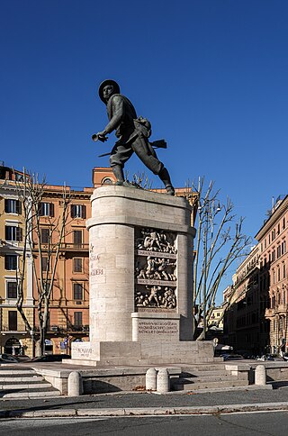
The Monument to the Bersagliere is a statuary monument located in Piazzale di Porta Pia, near the spot, where Italian soldiers were able to breach the city walls of Rome in 1870, thus leading to the integration of Rome into the Kingdom of Italy. The monument stands to the north of the gate, outside the walls. Attached to the gate buildings, designed by Michelangelo, that once represented Porta Pia, is a Museum of the History of the Bersaglieri, established here in 1921.