Dibrugarh district (Pron:ˌdɪbru:ˈgor:) is a district in the state of Assam in India. The district headquarters are located within the city of Dibrugarh.

Lakhimpur district is an administrative district in the state of Assam in India. The district headquarter is located at North Lakhimpur. The district is bounded on the North by Siang and Papumpare districts of Arunachal Pradesh and on the East by Dhemaji District and Subansiri River. Majuli District stands on the Southern side and Biswanath District is on the West.

Sonitpur district [Pron: ˌsə(ʊ)nɪtˈpʊə or ˌʃə(ʊ)nɪtˈpʊə] is an administrative district in the state of Assam in India. The district headquarters is located at Tezpur.

Tinsukia is an industrial city. It is situated 480 kilometres (298 mi) north-east of Guwahati and 84 kilometres (52 mi) away from the border with Arunachal Pradesh.Tinsukia serves as the headquarters of the Moran Autonomous Council, which is the governing council of the Morans.

Namrup is a small town situated close to the foothills of the Patkai Hills in the extreme southeastern part of Assam, India. The river Dihing or Disang flows through it. Namrup is situated in amidst wet-paddy fields, indigenous Assamese villages, orchards, large tea-gardens and densely forested hills. Administratively Namrup is located within Dibrugarh district and is today an important industrial town of Assam. Namrup is approximately 75 km from Dibrugarh by road towards the south-east and approximately 50 km from Tinsukia towards the south. It is also a small railway station in Dibrugarh-Guwahati broad-gauge railway line. The nearest airport is Dibrugarh located at a distance of approximately 70 km. Other urban areas close to Namrup are Naharkatiya - 18 km, Duliajan - 35 km, Sonari - 20 km, Moran - 55 km, etc. by roadways. Namrup is located around 500 km east of Guwahati, the largest city in the North East Region.
Dhemaji is a small town and the headquarters of the Dhemaji district in the state of Assam, India. It is situated on the north bank of the Brahmaputra River and serves as an important administrative and commercial centre for the surrounding area.The town is known for its serene environment, traditional Assamese culture, and proximity to natural attractions like hills, rivers and forests.

Jorhat is an administrative district of the Indian state of Assam situated in the central part of the Brahmaputra Valley. The district is bounded by Majuli on north, Nagaland state on the south, Sivasagar on the east and Golaghat on the west. On the north of the district, the river Brahmaputra forms the largest riverine island of the world. The administrative seat is at Jorhat city.
Dhemaji district is an administrative district in the state of Assam in India. The district headquarters are located in Dhemaji and commercial headquarters are located in Silapathar. Dhemaji covers an area of 3,237 km2 and has a population of 686,133. The predominant religion is Hinduism, with Hindus comprising approximately 95.47% of the population.

Suhungmung, or Dihingia Roja was one of the most prominent Ahom Kings who ruled at the cusp of Assam's medieval history. His reign broke from the early Ahom rule and established a multi-ethnic polity in his kingdom. Under him the Ahom Kingdom expanded greatly for the first time since Sukaphaa, at the cost of the Chutia and the Dimasa kingdoms. He also successfully defended his kingdom against Muslim invasions, first by a general called Bar Ujjir and another by Turbak Khan. During his time, the Khen dynasty collapsed and the Koch dynasty ascended in the Kamata kingdom. His general, Ton-kham, pursued the Muslims up to the Karatoya river, the western boundary of the erstwhile Kamarupa Kingdom, the farthest west an Ahom military force had ventured in its entire six hundred years of rule.

Duliajan is an industrial town of Dibrugarh district in the Indian state of Assam located in the upper north-east corner of India. The town is about 45 km east of Dibrugarh City. It is particularly known for its oil related industry, Oil India Limited, one of the country's largest oil and gas companies. There is also other central government owned companies like B.C.P.L. GDU Station, N.E.E.P.C.O., D.N.P.L., LPG Plant and the Shivani company which is India's largest private company for drilling. Assam Gas Company Limited, which carries out business related to natural gas in India owned by the Government of Assam, is also located in this township.
Moranhat is a small town and a town area committee in Charaideo district in the Indian state of Assam.The town is divided by N.H 37 into Charaideo and Dibrugarh district.
Naharkatia is a town and a Municipal board in Dibrugarh district in the Indian state of Assam. It is well known for petroleum and gas reserves. Earlier, Duliajan, the head office town of Oil India Limited was in its circle. However, the towns are close, within a 30-minute journey.
Silapathar is a small town in Dhemaji district in the Indian state of Assam. The town is on the northern bank of the Brahmaputra River and is 470 kilometres (290 mi) from the city of Guwahati and just six km (3.7 mi) from border of Arunachal Pradesh. The longest rail cum road bridge in India connects Silapathar to Dibrugarh. Historical Malinithan mandir is located around ten km (6.2 mi) from Silapathar.

Margherita is a census town in Tinsukia district in the Indian state of Assam. The sub-district town is surrounded by hills, tea gardens, forests and the Dihing River. It has a golf course at the foot of the hills and a small stream running through. Although considered to be a small town, Margherita has several hospitals and educational institutions and is regularly frequented by visitors on account of it being the last proper town of Upper Assam. The name Margherita actually derives from the Italian queen and dates back to the late 19th century as a token appreciation for the Italian Chief Engineer of a rail section Chevalier R Paganini who supervised the construction. Margherita was known for its collieries much developed by the British. Coal India Ltd has the biggest industrial plant here. The town is also known as Coal Queen as it is famous for coal business. Apart from this there are other industrial plants like Kitply and Tata Tea, along with minor plywood industries and tea gardens. Margherita has Tea Estates of the Williamson Magor Group. Namdang Tea Estate, Dirok Tea Estate, Dehing Tea Estate, Bogapani Tea Estate and Margherita Tea Estate are the 5 famous estates of the McLeod Russel India Limited Group situated at the sub division Margherita. McLeod Russel India Limited is one of the largest tea producers in Asia.
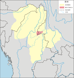
Upper Assam is an administrative division of the state of Assam comprising the undivided Lakhimpur and Sivasagar districts, of the upper reaches of the Brahmaputra valley. The other divisions are: Lower Assam, North Assam and Hills and Barak Valley. The division is under the jurisdiction of a Commissioner, stationed at Jorhat.

The Chutia Kingdom was a late medieval state that developed around Sadiya in present Assam and adjoining areas in Arunachal Pradesh. It extended over almost the entire region of present districts of Lakhimpur, Dhemaji, Tinsukia, and some parts of Dibrugarh in Assam, as well as the plains and foothills of Arunachal Pradesh. The kingdom fell around the year 1524 to the Ahom Kingdom after a series of conflicts and the capital area ruled by the Chutia rulers became the administrative domain of the office of Sadia Khowa Gohain of the Ahom kingdom.
Moran (Morān) is an extinct Boro-Garo language which was spoken in Assam in Northeast India and related to Dimasa language. The census returned 78 speakers in 1901, 24 in 1911 and none in 1931, and the only source of this language exists in a 1904 article by P R Gurdon. The speakers of this language have shifted to the Assamese language. The name "Moran" reportedly means 'forest dweller'.
Assam – 16th largest, 15th most populous and 26th most literate state of the 28 states of the democratic Republic of India. Assam is at 14th position in life expectancy and 8th in female-to-male sex ratio. Assam is the 21st most media exposed states in India. The Economy of Assam is largely agriculture based with 69% of the population engaged in it. Growth rate of Assam's income has not kept pace with that of India's during the Post-British Era; differences increased rapidly since the 1970s. While the Indian economy grew at 6 percent per annum over the period of 1981 to 2000, the same of Assam's grew only by 3.3 percent.
The Moamoria were the adherents of the egalitarian, proselytizing Mayamara Satra of 18th-century Assam, who initiated the Moamoria rebellion against the Ahom kingdom in the 18th century. The rebellion weakened the Ahom kingdom to such an extent that the kingdom became vulnerable to repeated Burmese invasions of Assam and the subsequent colonization by the British. The Moamorias were also called Mataks. Over time, the main groups that had supported the Ahom kingdom came to owe allegiance to the Moamara sattra: Morans, the Sonowal Kacharis (gold-washers), Chutias, professional castes such as Hiras (potters), Tantis (weavers), Kaibartas, and Ahom nobles and officers. The largest group among the Mataks were the Morans, followed by the Chutias.

The Moran are an ethnic group found in the northeast Indian states of Assam and Arunachal Pradesh. They are of Tibeto-Burman origin and belong to the Kachari family. They speak Assamese language, though they used to speak Moran language which was alive until the early 20th century and was closely related to the Dimasa language. They once shared the same allied customs with other Kachari groups, but after their conversion to Vaishnavism, the customs began to diminish, but still, those customs can be seen intermixed with Vaishnavism.