Morgan Covered Bridge

Last updated
Morgan Covered Bridge
MorganBridge.JPG
Bridge in U.S. state of Vermont
Coordinates 44°44′35″N72°43′41″W / 44.743°N 72.728°W / 44.743; -72.728
CarriesAutomobile
CrossesNorth Branch of Lamoille River
Locale Belvidere, Vermont
Maintained byTown of Belvidere
ID number VT-08-07
Characteristics
DesignCovered, Queenpost
MaterialWood
Total length70 ft 11 in (21.62 m)
Width12 ft 2.75 in (3.73 m)
No. of spans1
Load limit5 tons
Clearance above 8 ft 6 in (2.59 m)
History
Constructed byLewis Robinson, et al.
Construction end1887 (1887)
USA Vermont location map.svg
Red pog.svg
Usa edcp location map.svg
Red pog.svg
Coordinates 44°44′36″N72°43′40″W / 44.74333°N 72.72778°W / 44.74333; -72.72778 Coordinates: 44°44′36″N72°43′40″W / 44.74333°N 72.72778°W / 44.74333; -72.72778
Area1 acre (0.40 ha)
NRHP reference No. 74000229 [1]
Added to NRHPNovember 19, 1974

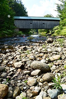
The Morgan Covered Bridge, also known as the Upper Covered Bridge [2] is a wooden covered bridge that crosses the North Branch Lamoille River in Belvidere, Vermont on Morgan Bridge Road. Built about 1887, it is one of two covered bridges in Belvidere, and one of five in a five-mile span that all cross the same river. It was listed on the National Register of Historic Places in 1974. [1]

Contents

Description

The Morgan Covered Bridge is located west of the center of Belvidere, carrying Morgan Bridge Road, a short connector between Back Road (running on the north side of the North Branch Lamoille River) and Vermont Route 109 (running to its south). It is a single-span Queen post truss structure, 62 feet (19 m) long and 15 feet (4.6 m) wide, with a roadway width of 12.5 feet (3.8 m). Its trusses include iron rods joining the apexes of the diagonals to the bottom chords. It has a gabled metal roof, and its exterior is finished in vertical board siding, which wraps around to the insides of the portals. The siding stops short of the eaves, leaving an open strip below the roof. The portal openings are framed as segmented arches. The bridge rests on abutments of stone and concrete. [3]

History

The bridge was built by Lewis Robinson, Charles Leonard and Fred Tracy. It is one of two 19th-century covered bridges (the other is the Mill Covered Bridge further west), and one of five on the North Branch Lamoille in Belvidere or neighboring Waterville, all within a five-mile span. [3]

There have been no major repairs necessary with this bridge recently, save for a new standing seam metal roof which a large number of covered bridges in Vermont received due to a grant. A study in the 1990s by the Vermont Agency of Transportation revealed that certain design details of the trusses allowed the bridge to be rated for a 9-ton load (1 ton more than the standard load limit for wooden deck bridges). [4] At this time, a sign at the bridge posts the limit at 5 tons.

Morgancoveredbridge.jpg

See also

Related Research Articles

<span class="mw-page-title-main">Gold Brook Covered Bridge</span> United States historic place

Gold Brook Covered Bridge, also known as Stowe Hollow Bridge or Emily's Bridge, is a small wooden covered bridge in the town of Stowe, Lamoille County, Vermont, carrying Covered Bridge Road over Gold Brook. Built in 1844, it is the only 19th-century covered bridge in the state built using wooden Howe trusses and carrying a public roadway. It was added to the National Register of Historic Places in 1974.

<span class="mw-page-title-main">Church Street Covered Bridge</span> Bridge in Waterville, Vermont

The Church Street Covered Bridge, also called the Village Covered Bridge, is a wooden covered bridge that crosses the North Branch of the Lamoille River in Waterville, Vermont off State Route 109. Built in the late 19th century, it is one of five covered bridges in a space of about five miles that cross the North Branch Lamoille. It was listed on the National Register of Historic Places in 1974.

<span class="mw-page-title-main">Gates Farm Covered Bridge</span> Bridge in Cambridge, Vermont

The Gates Farm Covered Bridge is a covered bridge that crosses the Seymour River off State Route 15 in Cambridge, Vermont. Built in 1897, it is last bridge to be built during the historic period of covered bridge construction with the Burr arch design. It was listed on the National Register of Historic Places in 1974.

<span class="mw-page-title-main">Poland Covered Bridge</span> Bridge in Cambridge, Vermont

The Poland Covered Bridge, also known as the Junction Covered Bridge or the Cambridge Junction Covered Bridge is a covered bridge that carries Cambridge Junction Road across the Lamoille River off State Route 15 in Cambridge, Vermont. It was listed on the National Register of Historic Places in 1974. The bridge is of Burr arch design, built by George W. Holmes in 1887.

<span class="mw-page-title-main">Grist Mill Covered Bridge</span> Bridge in Cambridge, Vermont

The Grist Mill Covered Bridge, also known as the Scott Covered Bridge, the Bryant Covered Bridge, and the Canyon Covered Bridge, is a covered bridge that carries Canyon Road across the Brewster River, off Vermont Route 108 in Cambridge, Vermont. Built in the 19th century, it is one of a small number of surviving Burr arch truss bridges in the state, and is one of three left in Cambridge. It was listed on the National Register of Historic Places in 1974.

<span class="mw-page-title-main">Power House Covered Bridge</span> Bridge in Johnson, Vermont

The Power House Covered Bridge, also known as the School Street Covered Bridge, is a covered bridge from 1872 that crosses the Gihon River off State Route 100C in Johnson, Vermont, US. It was listed on the National Register of Historic Places in 1974. The bridge's name is from a now obsolete hydroelectric generating station just upstream from it. The bridge is of Queen post truss design by an unknown builder.

<span class="mw-page-title-main">Scribner Covered Bridge</span> Bridge in Johnson, Vermont

The Scribner Covered Bridge, also known as the Mudgett Covered Bridge, is a covered bridge that carries Rocky Road across the Gihon River off State Route 100C in eastern Johnson, Vermont. It was listed on the National Register of Historic Places in 1974. It is one of a small number of Vermont's covered bridges that are the result of covering an existing open bridge.

<span class="mw-page-title-main">Gifford Covered Bridge</span> Bridge in Randolph, Vermont

The Gifford Covered Bridge, also called the C.K. Smith Covered Bridge, is a wooden covered bridge that crosses the Second Branch of the White River in Randolph, Vermont on Hyde Road. It was listed on the National Register of Historic Places in 1974. It is one of two bridges in the state that was uncovered when first built, its trusses boxed for shelter.

<span class="mw-page-title-main">Slaughter House Covered Bridge</span> Bridge in Northfield, Vermont

The Slaughter HouseCovered Bridge is a wooden covered bridge that carries Slaughterhouse Road across the Dog River in Northfield, Vermont. The Queen post truss bridge is one of five surviving 19th-century bridges in the town. It was listed on the National Register of Historic Places in 1974.

<span class="mw-page-title-main">Mill Covered Bridge (Belvidere, Vermont)</span> Bridge in Belvidere, Vermont

The Mill Covered Bridge is a wooden covered bridge that crosses the North Branch Lamoille River on Back Road in Belvidere, Vermont. Built about 1890, it is one of two surviving covered bridges in the rural community. It was listed on the National Register of Historic Places in 1974.

<span class="mw-page-title-main">Montgomery Covered Bridge</span> Bridge in Waterville, Vermont

The Montgomery Covered Bridge, also known as the Lower Covered Bridge is a wooden covered bridge that carries Montgomery Road across the North Branch of the Lamoille River in Waterville, Vermont. Built in 1887, it is one of three covered bridges in the town, and one of five on the river in a five-mile span. It was listed on the National Register of Historic Places in 1974.

<span class="mw-page-title-main">Flint Covered Bridge</span> Covered bridge in Vermont

The Flint Covered Bridge is a historic covered bridge carrying Bicknell Hill Road over the First Branch White River in northern Tunbridge, Vermont. Built in 1845, it is the oldest of five 19th-century covered bridges in Tunbridge, representing one of the highest concentrations of covered bridges in the state. It was listed on the National Register of Historic Places on September 10, 1974.

<span class="mw-page-title-main">Waterman Covered Bridge</span> United States historic place

The Waterman Covered Bridge was an historic covered bridge in Johnson, Vermont that carried Waterman Road across Waterman Creek. Built in 1868, it was one of three surviving 19th-century bridges in the town. It was listed on the National Register of Historic Places in 1974, and collapsed in January 1982.

<span class="mw-page-title-main">Fisher Covered Railroad Bridge</span> United States historic place

The Fisher Covered Railroad Bridge is a covered bridge in Wolcott, Vermont. Built in 1908, it originally carried the St. Johnsbury and Lamoille County Railroad line over the Lamoille River. Now closed, it was the last covered bridge in Vermont to carry railroad traffic, and is a rare surviving example in the state of a double Town lattice truss. It was listed on the National Register of Historic Places in 1974.

<span class="mw-page-title-main">Cilley Covered Bridge</span> United States historic place

The Cilley Covered Bridge is a historic 19th-century covered bridge, carrying Howe Lane across the First Branch White River a short way south of the village of Tunbridge, Vermont. Built in 1883, it is a fine example of a king-post truss structure, and is one of the town's five 19th-century covered bridges. It was listed on the National Register of Historic Places in 1974.

<span class="mw-page-title-main">Larkin Covered Bridge (North Tunbridge, Vermont)</span> United States historic place

The Larkin Covered Bridge is a historic covered bridge, carrying Larkin Road across the First Branch White River in northern Tunbridge, Vermont. Built in 1902, it is one of the last documented covered bridges to be built in Vermont during the historic period of bridge construction, and is one of five covered bridges in the town. It was listed on the National Register of Historic Places in 1974.

<span class="mw-page-title-main">East Shoreham Covered Railroad Bridge</span> United States historic place

The East Shoreham Covered Railroad Bridge is a historic covered bridge spanning the Lemon Fair River near East Shoreham, Vermont. Built in 1897 by the Rutland Railroad Company, it is the state's only surviving example of a wooden Howe truss railroad bridge. It was listed on the National Register of Historic Places in 1974.

<span class="mw-page-title-main">Burrington Covered Bridge</span> United States historic place

The Burrington Covered Bridge is a historic queenpost truss covered bridge in Lyndon, Vermont. Built in the 19th century, it is one of five covered bridges in Lyndon. It formerly carried Burrington Bridge Road across the Passumpsic River; it has been bypassed by a modern bridge. It was listed on the National Register of Historic Places in 1974.

<span class="mw-page-title-main">Jaynes Covered Bridge</span> United States historic place

The Jaynes Covered Bridge is a historic covered bridge, carrying Codding Hollow Road across the North Branch Lamoille River in Waterville, Vermont. Built in 1877, it is one of three 19th-century covered bridges in the town, and one of five to span the North Branch Lamoille in a five-mile span. It was listed on the National Register of Historic Places in 1974.

<span class="mw-page-title-main">Red Covered Bridge (Morristown, Vermont)</span> United States historic place

The Red Covered Bridge is a historic covered bridge, carrying Cole Hill Road across Sterling Brook in Morristown, Vermont. Built in 1896, it is the only surviving 19th-century covered bridge in the town, and one of the last to be built during the historic period of covered bridge construction in the state. It is of queen post truss design, and was listed on the National Register of Historic Places in 1974.

References

  1. 1 2 "National Register Information System". National Register of Historic Places . National Park Service. July 9, 2010.
  2. U.S. Geological Survey Geographic Names Information System: Morgan Covered Bridge
  3. 1 2 Hugh Henry (1974). "NRHP nomination for Morgan Covered Bridge". National Park Service . Retrieved 2016-12-20. with photos from 1974
  4. Evans, Benjamin; Evans, June (2004). New England's Covered Bridges. University Press of New England. ISBN   1-58465-320-5.