
Cardiff Castle is a medieval castle and Victorian Gothic revival mansion located in the city centre of Cardiff, Wales. The original motte and bailey castle was built in the late 11th century by Norman invaders on top of a 3rd-century Roman fort. The castle was commissioned either by William the Conqueror or by Robert Fitzhamon, and formed the heart of the medieval town of Cardiff and the Marcher Lord territory of Glamorgan. In the 12th century the castle began to be rebuilt in stone, probably by Robert of Gloucester, with a shell keep and substantial defensive walls being erected. Further work was conducted by the 6th Earl of Gloucester in the second half of the 13th century. Cardiff Castle was repeatedly involved in the conflicts between the Anglo-Normans and the Welsh, being attacked several times in the 12th century, and stormed in 1404 during the revolt of Owain Glyndŵr.

Pembroke Castle is a medieval castle in the centre of Pembroke, Pembrokeshire in Wales. The castle was the original family seat of the Earldom of Pembroke. A Grade I listed building since 1951, it underwent major restoration during the early 20th century.

Criccieth Castle is a ruined thirteenth-century castle in Criccieth, Gwynedd, Wales. It is located on a rocky headland overlooking Tremadog Bay and consists of an inner ward almost surrounded by an outer ward. The twin-towered inner gatehouse is the most prominent remaining feature and survives to almost its full height, as does the inner curtain wall. The outer curtain wall, the inner ward buildings, and the castle's other three towers are significantly more ruinous, and in places survive only as foundations.

Merthyr Tydfil is the main town in Merthyr Tydfil County Borough, Wales, administered by Merthyr Tydfil County Borough Council. It is about 23 miles (37 km) north of Cardiff. Often called just Merthyr, it is said to be named after Tydfil, daughter of King Brychan of Brycheiniog, who according to legend was slain at Merthyr by pagans about 480 CE. Merthyr generally means "martyr" in modern Welsh, but here closer to the Latin martyrium: a place of worship built over a martyr's relics. Similar place names in south Wales are Merthyr Cynog, Merthyr Dyfan and Merthyr Mawr.

The River Taff is a river in Wales. It rises in the Brecon Beacons as two rivers, the Taf Fechan and the Taf Fawr before becoming one just north of Merthyr Tydfil. At Cardiff, it empties into the Bristol Channel.
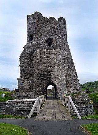
Aberystwyth Castle is a Grade I listed Edwardian fortress located in Aberystwyth, Ceredigion, Mid Wales. It was built in response to the First Welsh War in the late 13th century, replacing an earlier fortress located a mile to the south. During a national uprising by Owain Glyndŵr, the Welsh captured the castle in 1404, but it was recaptured by the English four years later. From 1637 it housed a Royal mint of Charles I, which minted coins from locally mined silver. The castle was slighted by Oliver Cromwell in 1649.
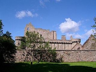
Craigmillar Castle is a ruined medieval castle in Edinburgh, Scotland. It is three miles (4.8 km) south-east of the city centre, on a low hill to the south of the modern suburb of Craigmillar. The Preston family of Craigmillar, the local feudal barons, began building the castle in the late 14th century and building works continued through the 15th and 16th centuries. In 1660, the castle was sold to Sir John Gilmour, Lord President of the Court of Session, who breathed new life into the ageing castle. The Gilmours left Craigmillar in the 18th century for a more modern residence, nearby Inch House, and the castle fell into ruin. It is now in the care of Historic Environment Scotland as a scheduled monument, and is open to the public.

Ewloe Castle is a native Welsh castle built by the Kingdom of Gwynedd near the town of Ewloe in Flintshire, Wales. The castle, which was one of the last fortifications to be built by the native Princes of Wales, was abandoned at the beginning of the invasion of Wales by Edward I in 1277. Its construction, using locally quarried sandstone, appears to have continued piecemeal over many years and may have not been completed. On taking the castle, the English Crown gave it little military value and allowed it to fall into ruin.

Cooling Castle is a 14th-century quadrangular castle in the village of Cooling, Kent on the Hoo Peninsula about 6 miles (9.7 km) north of Rochester. It was built in the 1380s by the Cobham family, the local lords of the manor, to guard the area against French raids into the Thames Estuary. The castle has an unusual layout, comprising two walled wards of unequal size next to each other, surrounded by moats and ditches. It was the earliest English castle designed for the use of gunpowder weapons by its defenders.

Craignethan Castle is a ruined castle in South Lanarkshire, Scotland. It is located above the River Nethan, a tributary of the River Clyde, at NS816464. The castle is two miles west of the village of Crossford, and 4.5 miles north-west of Lanark. Built in the first half of the 16th century, Craignethan is recognised as an excellent early example of a sophisticated artillery fortification, although its defences were never fully tested.

Cyfarthfa Castle is a castellated mansion that was the home of the Crawshay family, ironmasters of Cyfarthfa Ironworks in Park, Merthyr Tydfil, Wales. The house commanded a view of the valley and the works, which ‘at night, offer a truly magnificent scene, resembling the fabled Pandemonium, but on which the eye may gaze with pleasure’. Cyfarthfa loosely translates from the Welsh for place of barking. The reason is hunting dogs were regularly heard in this area of the town, hunting polecats and weasels among others.

Haverfordwest Castle is a castle located in the town centre at Haverfordwest, Pembrokeshire, south Wales, located in a naturally defensive position at the end of a strong, isolated ridge. The castle was established during Norman times in 1120 but much of the architecture remaining today is dated to 1290. For centuries the castle was an English stronghold. There are several other notable castles in area; Wiston Castle lies 6 miles (9.7 km) to the northeast and Pembroke Castle lies 12 miles (19 km) to the south.
Prudhoe Castle is a ruined medieval English castle situated on the south bank of the River Tyne at Prudhoe, Northumberland, England. It is a Scheduled Ancient Monument and a Grade I listed building.
Theophilus Aneurin Rees was a Welsh rugby union forward who represented Llandovery College at club level. He was capped once for Wales, in the country's very first international rugby match.

St Quintins Castle is a castle located in the village of Llanblethian, Cowbridge, Wales. It is a scheduled monument and a Grade II* listed building and is under the care of Cadw. The site was first occupied with a defensive structure in about 1102 and the gatehouse and further building work took place around 1312. It was later used as a prison and was reported as being in a ruinous state by 1741.
Penydarren is a community and electoral ward in Merthyr Tydfil County Borough in Wales.

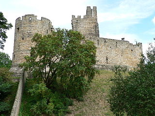
Warkworth Castle is a ruined medieval castle in Warkworth in the English county of Northumberland. The village and castle occupy a loop of the River Coquet, less than a mile from England's north-east coast. When the castle was founded is uncertain: traditionally its construction has been ascribed to Prince Henry of Scotland, Earl of Northumbria, in the mid-12th century, but it may have been built by King Henry II of England when he took control of England's northern counties. Warkworth Castle was first documented in a charter of 1157–1164 when Henry II granted it to Roger fitz Richard. The timber castle was considered "feeble", and was left undefended when the Scots invaded in 1173.
Cyfarthfa is a community and electoral ward in the west of the town of Merthyr Tydfil in Merthyr Tydfil County Borough, Wales.

Merthyr Tydfil County Borough is a county borough in the south-east of Wales. In 2022, it had an estimated population of 58,883, making it the smallest local authority in Wales by population. It is located in the historic county of Glamorgan and takes its name from the town with the same name. The county borough consists of the northern part of the Taff Valley and the smaller neighbouring Taff Bargoed Valley. It borders the counties of Rhondda Cynon Taf to the west, Caerphilly County Borough to the east, and Powys to the north.
 View of some internal features of remaining room at Morlais Castle
 Morlais Castle Internal Room
 external view of the only remaining room at Morlais castle.

