
A ghost town or alternatively deserted city or abandoned city is an abandoned village, town, or city, usually one that contains substantial visible remaining buildings and infrastructure such as roads. A town often becomes a ghost town because the economic activity that supported it has failed, or due to natural or human-caused disasters such as floods, prolonged droughts, extreme heat or extreme cold, government actions, uncontrolled lawlessness, war, pollution, or nuclear disasters. The term can sometimes refer to cities, towns, and neighbourhoods that are still populated, but significantly less so than in past years; for example, those affected by high levels of unemployment and dereliction.

Internment is the imprisonment of people, commonly in large groups, without charges or intent to file charges. The term is especially used for the confinement "of enemy citizens in wartime or of terrorism suspects". Thus, while it can simply mean imprisonment, it tends to refer to preventive confinement rather than confinement after having been convicted of some crime. Use of these terms is subject to debate and political sensitivities. Internment is also occasionally used to describe a neutral country's practice of detaining belligerent armed forces and equipment on its territory during times of war, under the Hague Convention of 1907.
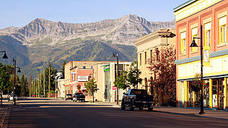
Fernie is a city in the Elk Valley area of the East Kootenay region of southeastern British Columbia, Canada, located on BC Highway 3 on the eastern approaches to the Crowsnest Pass through the Rocky Mountains. Founded in 1898 and incorporated as the City of Fernie in July 1904, the municipality has a population of over 5,000 with an additional 2,000 outside city limits in communities under the jurisdiction of the Regional District of East Kootenay. A substantial seasonal population swells the city during the winter months.

Beginning in 1942, the internment of Japanese Canadians occurred when over 22,000 Japanese Canadians—comprising over 90% of the total Japanese Canadian population—from British Columbia were forcibly relocated and interned in the name of national security. The majority were Canadian citizens by birth. This decision followed the events of the Japanese invasions of British Hong Kong and Malaya, the attack on Pearl Harbor in Hawaii, and the subsequent Canadian declaration of war on Japan during World War II. This forced relocation subjected many Japanese Canadians to government-enforced curfews and interrogations, job and property losses, and forced repatriation to Japan.

New Denver is at the mouth of Carpenter Creek, on the east shore of Slocan Lake, in the West Kootenay region of southeastern British Columbia. The village is 47 kilometres (29 mi) west of Kaslo on Highway 31A, and 47 kilometres (29 mi) southeast of Nakusp and 32 kilometres (20 mi) northeast of Slocan on Highway 6.
Masajiro Miyazaki, CM was a Japanese-Canadian osteopathic physician who practised in Vancouver prior to World War II. During World War II, he was appointed as a coroner by the British Columbia Provincial Police in the town of Lillooet, British Columbia. In addition to coroner's duties he also served as effective general practitioner in the Lillooet area, including for the area's four wartime "self-supporting centres". Miyazaki's practice also included the Japanese Canadian internment camp at Taylor Lake. Towards the end of his life, Miyazaki was recognized for his services to the community, which included founding the local ambulance service and instigating a proper hospital for Lillooet, by being enrolled in the Order of Canada.

The Ukrainian Canadian internment was part of the confinement of "enemy aliens" in Canada during and for two years after the end of the First World War, lasting from 1914 to 1920, under the terms of the War Measures Act.
Butedale is a ghost town on Princess Royal Island, in British Columbia, Canada. It was founded in 1918 as a fishing, mining and logging camp. Initially the salmon cannery was established by Western Packers which was purchased and operated by the Canadian Fishing Company until it ceased operating in the 1950s. At its peak the summertime population of Butedale was over 400 people.
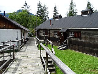
Nikkei Internment Memorial Centre is a museum that preserves and interprets one of ten Canadian concentration camps where more than 27,000 Japanese Canadians were incarcerated by the Canadian government during and after World War II. The centre was designated a National Historic Site of Canada in 2007.
Emory Creek Provincial Park is a provincial park in British Columbia, Canada, located on the west side of the Fraser River just south of the town of Yale. It commemorates the location of a large boomtown, variously known as Emory, Emory Bar or Emory City, that first rose during the Fraser Canyon Gold Rush but became a major construction town during the building of the Canadian Pacific Railway in the 1880s.
Emory Creek in 1858 was a tent and shack camp, established by miners in search of gold. When it became evident that the gold was not available in the amounts estimated, the miners started moving north on the Fraser River. A few Chinese remained in the area. The area came into the hands of a man named Walker, who felt Emory Creek would become the head of riverboat navigation on the Fraser. Eventually, he sold the land to the Oppenheimer Brothers in early 1879. In the fall of 1879, Emory was chosen by the C.P.R. as the western terminus. In a short time it became Emory Creek. The town consisted of thirteen streets with its own newspaper, various shops, a brewery, nine saloons and a sawmill. When Yale was made the terminus, Emory was all but abandoned by 1885, with the completion of the railway. Today, it is an easily accessible treed campground with paved roads and flush outhouses.

Greenwood is a city in south central British Columbia. It was incorporated in 1897 and was formerly one of the principal cities of the Boundary Country smelting and mining district. It was incorporated as a city originally and has retained that title despite the population decline following the closure of the area's industries.

Alexandria or Fort Alexandria is a National Historic Site of Canada on the Fraser River in British Columbia, and was the end of the Old Cariboo Road and the Cariboo Wagon Road. It is located on Highway 97, 103 miles (166 km) north of 100 Mile House and 28 miles (45 km) south of Quesnel.
Japanese Canadians are Canadian citizens of Japanese ancestry. Japanese Canadians are mostly concentrated in Western Canada, especially in the province of British Columbia, which hosts the largest Japanese community in the country with the majority of them living in and around Vancouver. In 2016, there were 121,485 Japanese Canadians throughout Canada.
Cascade City or Cascade was a Canadian Pacific Railway construction era boom town in the Boundary Country of the West Kootenay region of British Columbia, Canada. Because of its location near the Canada–United States border, it was also called the "Gateway to the Boundary Country".
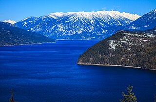
The Slocan Valley is a valley in the West Kootenay region of southeastern British Columbia.
Copper Mountain was an important copper-mining company town in the Similkameen Country of the Southern Interior of British Columbia, Canada, just south of the town of Princeton.

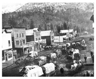
Phoenix is a ghost town in the Boundary Country of British Columbia, Canada, 11 km east of Greenwood. Once called the “highest city in Canada” by its citizens it was a booming copper mining community from the late 1890s until 1919. In its heyday it was home to 1,000 citizens and had an opera house, twenty hotels, a brewery and its own city hall. Phoenix’s magistrate, Judge Willie Williams, who served there from 1897 until 1913, became famous for his booming declaration, “I am the highest judge, in the highest court, in the highest city in Canada.” In 1911, Phoenix’s hockey team won the provincial championship and asked for the right to compete for the Stanley Cup, but it was too late to qualify. The Granby Consolidated Mining, Smelting and Power Company operated the Phoenix Mine, a copper mine that produced 13,678,901 tons of ore before operations ceased on June 14, 1919.

Sunshine Valley, formerly named Tashme, is an unincorporated community consisting of cabins, tiny homes, and RV parks on the Crowsnest Highway between of the town of Hope (NW) and the entrance to Manning Park in the Cascade Mountains of British Columbia. The community has its own volunteer fire department (SVVFD), recreation centre, heated outdoor pool, and playground. As of 2016, the population of Sunshine Valley is 177.
Corbin is a ghost town in British Columbia, Canada. It was a coal mining community located at the foot of Coal Mountain, south of the Crowsnest Pass in the southern Canadian Rockies.
