
The Eifel is a low mountain range in western Germany, eastern Belgium and northern Luxembourg. It occupies parts of southwestern North Rhine-Westphalia, northwestern Rhineland-Palatinate and the southern area of the German-speaking Community of Belgium.

A maar is a broad, low-relief volcanic crater caused by a phreatomagmatic eruption. A maar characteristically fills with water to form a relatively shallow crater lake, which may also be called a maar.

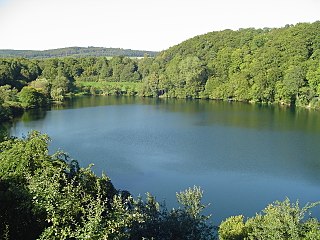
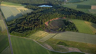
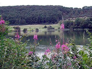
Mosbruch is an Ortsgemeinde – a municipality belonging to a Verbandsgemeinde, a kind of collective municipality – in the Vulkaneifel district in Rhineland-Palatinate, Germany. It belongs to the Verbandsgemeinde of Kelberg, whose seat is in the like-named municipality.

Raised bogs, also called ombrotrophic bogs, are acidic, wet habitats that are poor in mineral salts and are home to flora and fauna that can cope with such extreme conditions. Raised bogs, unlike fens, are exclusively fed by precipitation (ombrotrophy) and from mineral salts introduced from the air. They thus represent a special type of bog, hydrologically, ecologically and in terms of their development history, in which the growth of peat mosses over centuries or millennia plays a decisive role. They also differ in character from blanket bogs which are much thinner and occur in wetter, cloudier climatic zones.

The Volcanic Eifel or Vulkan Eifel is a region in the Eifel Mountains in Germany that is defined to a large extent by its volcanic geological history. Characteristic of this volcanic field are its typical explosion crater lakes or maars, and numerous other signs of volcanic activity such as volcanic tuffs, lava streams and volcanic craters like the Laacher See. The Volcanic Eifel is still volcanically active today. One sign of this activity is the escaping gases in the Laacher See.
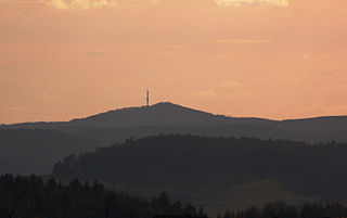
At 674.9 metres (2,214 ft) the Hochkelberg is one of the ten highest mountains in the Vulkan Eifel in Germany. It is a former stratovolcano, at the southern foot of which lies the Mosbrucher Weiher, an explosion crater lake or maar. Below the summit of the Hochkelberg is a transmission tower.

The Volcano Park in Mayen-Koblenz is a geopark in the rural district of Mayen-Koblenz in the eastern Vulkan Eifel, Germany. It was founded in 1996 and wraps around the Laacher See. Together with the Volcano Park, Brohltal/Laacher See and the Vulkan Eifel Nature and Geo-Park, it forms part of the national Eifel Volcano Land Geo-Park. The three parks are connected by the 280-kilometre-long German Volcano Route.

The Moosbach is a stream, approximately 6.6 kilometres (4.1 mi) long, in the South Palatine part of the Wasgau region in the German state of Rhineland-Palatinate. It is a right tributary of the Lauter, whose upper reaches are known as the Wieslauter.
The Ulmener Maar is a maar in the Eifel mountains of Germany in the immediate vicinity of the town of Ulmen in the state of Rhineland-Palatinate. The lake is up to 37 metres deep and is surrounded by an embankment of tuff with an average height of 20 metres, which was formed from the erupted material of the former volcano. By the southern edge of the embankment are the ruins of a knight's castle, Ulmen Castle dating to the 11th century.

The Booser Doppelmaar comprises two maars that have silted up and, today, form shallow depressions in the countryside. They lie on the territory of the village of Boos, a few hundred metres west of the village itself. The two maars were formed 10,150 to 14,160 years ago and belong to the Quaternary volcano field of the Volcanic Eifel. From a natural region perspective it lies in the south of the Hohe Acht Upland, ca. 7.8 km south of the summit of the Hohe Acht.
The Dürres Maar is a maar located in the vicinity of the village of Gillenfeld, Germany in the West Eifel mountains about 400 metres northwest of the Holzmaar. The Dürres Maar ist a dry maar, the original maar lake has silted up. It is surrounded by an embankment of lapilli-tuff which has only been gently eroded and has a diameter of about 290 metres. The Dürres Maar was formed more than 25,000 years ago.

The Pulvermaar is a water-filled maar that lies southeast of Daun in the German state of Rhineland-Palatinate. Together with the Holzmaar it is one of the Gillenfeld maars.
The Holzmaar lies in the Volcanic Eifel in the German state of Rhineland-Palatinate almost halfway between Gillenfeld and Eckfeld. The maar has an area of about 6.8 hectares, a diameter of 325 metres (1,066 ft) and a depth of 21 metres (69 ft) and lies within a nature reserve, almost completely surrounded by woods. It is one of the two maars making up the Gillenfeld Maars, the other being the Pulvermaar.

The Meerfelder Maar is a maar by the village of Meerfeld not far from the town of Manderscheid in the Eifel in the German state of Rhineland-Palatinate.

The Schalkenmehrener Maar is a maar roughly 3 kilometres southeast of the town of Daun in the Eifel in the German state of Rhineland-Palatinate.

The Dreiser Weiher near Dreis-Brück in the vicinity of Daun in the German state of Rhineland-Palatinate is a tub-shaped maar in the Eifel mountains. It is up to 1,360 metres long and 1,160 metres wide. It is the second largest maar in the Eifel.
The Hitsche Maar lies in the Eifel Mountains between Bitburg and Ulmen. The maar has a diameter of 60 metres and a crater depth of 5 metres. Known as the "smallest maar in the Eifel", the Hitsche has silted up to form a sedge marsh.
The Immerather Maar is a maar in the municipality of Immerath in the county of Vulkaneifel in the German state of Rhineland-Palatinate. It is part of a designated nature reserve and Special Area of Conservation.

The Rockeskyller Kopf near Rockeskyll in the county of Vulkaneifel in the German state of Rhineland-Palatinate is a hill, 554.6 m above sea level (NHN), in the Eifel mountains. It is an extinct volcano complex from the Quaternary period, around 360,000 years old and is designated as a natural monument (ND-7233-420).
