
Scafell Pike is a mountain in the Lake District region of Cumbria, England. It has an elevation of 978 metres (3,209 ft) above sea level, making it the highest and the most prominent mountain in England. The mountain is part of the Scafell massif, an inactive volcano, and is one of the Southern Fells.

Wast Water or Wastwater is a lake located in Wasdale, a valley in the western part of the Lake District National Park, England. The lake is almost three miles long and more than one-third mile (500 m) wide. It is a glacial lake, formed in a glacially 'over-deepened' valley. It is the deepest lake in England at 258 feet (79 m). The surface of the lake is about 200 feet (60 m) above sea level, while its bottom is over 50 feet (15 m) below sea level. It is owned by the National Trust.

Pillar is a mountain in the western part of the English Lake District. Situated between the valleys of Ennerdale to the north and Wasdale to the south, it is the highest point of the Pillar group. At 892 metres (2,927 ft) it is the eighth-highest mountain in the Lake District. The fell takes its name from Pillar Rock, a prominent feature on the Ennerdale side, regarded as the birthplace of rock climbing in the district.
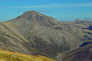
Great Gable is a mountain in the Lake District, United Kingdom. It is named after its appearance as a pyramid from Wasdale, though it is dome-shaped from most other directions. It is one of the most popular of the Lakeland fells, and there are many different routes to the summit. Great Gable is linked by the high pass of Windy Gap to its smaller sister hill, Green Gable, and by the lower pass of Beck Head to its western neighbour, Kirk Fell.

Buckbarrow is a small fell in the English Lake District overlooking the western end of Wastwater. It is featured in Alfred Wainwright’s Pictorial Guide to the Lakeland Fells and is given a height of 1,410 ft approximately; however, the Ordnance Survey and other guidebooks now give an altitude of 423 m (1,388 ft). The fell’s name means ‘The hill of the buck or goat’. It is derived either from the Old English word bucc meaning buck or the Old Norse word bokki meaning a male goat.

Kirk Fell is a fell in the Western part of the English Lake District. It is situated between Great Gable and Pillar on the long ring of fells surrounding the valley of Ennerdale, and also stands over Wasdale to the south. However, it is separated from its two higher neighbours by the low passes of Black Sail and Beck Head, giving it a high relative height and making it a Marilyn, the thirteenth highest in the Lake District.

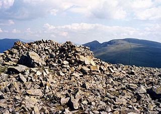
Seatallan is a mountain in the western part of the English Lake District. It is rounded, grassy and fairly unassuming, occupying a large amount of land. However, it is classed as a Marilyn because of the low elevation of the col connecting it to Haycock, its nearest higher neighbour to the north. The name Seatallan is believed to have a Cumbric origin, meaning "Aleyn's high pasture".

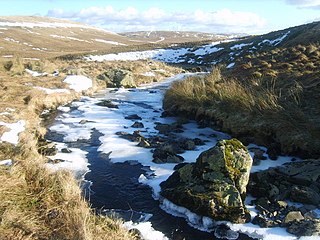
The River Irt is a river in the county of Cumbria in northern England. It flows for approximately 22 kilometres (14 mi) from its source in Wast Water to its estuary at Ravenglass.

Red Pike is a fell in the English Lake District. It is 826 m or 2,709 ft high and lies due north of Wast Water. It is often climbed as part of the Mosedale Horseshoe, a walk which also includes Pillar.

Scoat Fell is a fell in the western part of the English Lake District. It stands at the head of the Mosedale Horseshoe with its back to Ennerdale. Paths lead to Scoat Fell from Ennerdale over Steeple, from Wasdale over Red Pike, and along the ridge from Pillar.

Lingmell is a fell in the English Lake District, standing above the village of Wasdale Head. It is an outlier on the north-west flank of Scafell Pike, England’s highest mountain.
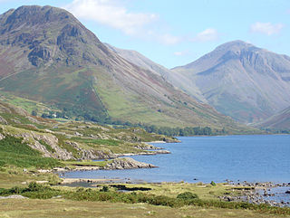
Yewbarrow is a fell, in the English Lake District, which lies immediately north of the head of Wast Water. It is 628 metres high and in shape resembles the upturned hull of a boat or a barrow. Yewbarrow is on the left in the classic view of Great Gable and Wast Water.

Steeple is a fell in the English Lake District. It is situated in the mountainous area between Ennerdale and Wasdale and reaches a height of 819 metres. Steeple is really part of Scoat Fell, being just the rocky northern projection of that fell. However, because of its prominent peak and steep crags it has earned the reputation of being a separate fell. The Lake District writer Alfred Wainwright rated Steeple and its name very highly saying, “Seen on a map, it commands the eye and quickens the pulse, seen in reality it does the same“.
Haycock is a mountain in the western part of the English Lake District. It rises between Scoat Fell and Caw Fell to the south of Ennerdale and the north of Wasdale. Haycock is an imposing dome-shaped fell, its popularity with walkers diminished somewhat by its remoteness. It can be climbed from either valley and offers fine mountain views.
Middle Fell is a hill or fell in the English Lake District. It is a satellite of Seatallan standing above the northern shore of Wastwater. Middle Fell can be climbed from Greendale near the foot of Wastwater, and a fine view of the lake backed by the Wastwater Screes is visible from the summit.

The Wasdale Horseshoe is a group of hills on the eastern fringe of the English Lake District, to the west of the A6, south of Shap, Cumbria. They surround the valley of Wasdale Beck, a tributary of Birk Beck and ultimately of the River Lune. The horseshoe is the subject of a chapter of Wainwright's book The Outlying Fells of Lakeland. This Wasdale should not be confused with the better known Wasdale, containing Wast Water, on the west of the Lake District.
The Crookdale Horseshoe is a group of hills on the eastern edge of the English Lake District, in Cumbria, west of the A6 road. They are the subject of a chapter of Wainwright's book The Outlying Fells of Lakeland. Wainwright describes an anticlockwise walk starting along the valley of Crookdale Beck to reach Lord's Seat at 1,719 feet (524 m), and returning over Robin Hood at 1,613 feet (492 m) and High House Bank at 1,627 feet (496 m). As he points out, the ridge forming the northern part of the "horseshoe" is described in his Wasdale Horseshoe chapter.
The Mosedale Horseshoe is a celebrated mountain walk around Mosedale in the English Lake District: starting at Wasdale Head, it includes Kirk Fell, Yewbarrow, Red Pike, Scoat Fell, and Pillar. It is a circular walk of 22.5 kilometres (14.0 mi) with a total ascent of 1,150 metres (3,770 ft).

