Moser Channel

Last updated
East view from the top of the Moser Channel arc of the Seven Mile Bridge Moser Channel top.jpg
East view from the top of the Moser Channel arc of the Seven Mile Bridge

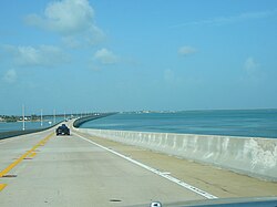
Moser Channel is the deepest passage spanned by the Seven Mile Bridge and is one of four predominant passages in the Florida Keys which allow exchange of waters to the north and west of the Keys (including Florida Bay and the Gulf of Mexico) with the Atlantic waters of Hawk Channel and the Florida Reef to the south and east. Moser Channel has an orientation perpendicular to the bridge. The other three Keys passages important to the exchange of south Florida coastal waters are Long Key Channel, Channel 5, and Channel 2.

Seven Mile Bridge Bridge in Florida, United States of America

The Seven Mile Bridge is a bridge in the Florida Keys, in Monroe County, Florida, United States. It connects Knight's Key in the Middle Keys to Little Duck Key in the Lower Keys. Among the longest bridges in existence when it was built, it is part of the Overseas Highway in the Keys, which is part of the 2,369-mile U.S. Route 1.

Florida Keys Coral cay archipelago in Florida, United States of America

The Florida Keys are a coral cay archipelago located off the southern coast of Florida, forming the southernmost portion of the continental United States. They begin at the southeastern coast of the Florida peninsula, about 15 miles (24 km) south of Miami, and extend in a gentle arc south-southwest and then westward to Key West, the westernmost of the inhabited islands, and on to the uninhabited Dry Tortugas. The islands lie along the Florida Straits, dividing the Atlantic Ocean to the east from the Gulf of Mexico to the northwest, and defining one edge of Florida Bay. At the nearest point, the southern part of Key West is just 90 miles (140 km) from Cuba. The Florida Keys are between about 23.5 and 25.5 degrees North latitude.

Florida Bay The bay between the southern end of the Florida mainland and the Florida Keys in the United States

Florida Bay is the bay located between the southern end of the Florida mainland and the Florida Keys in the United States. It is a large, shallow estuary that while connected to the Gulf of Mexico, has limited exchange of water due to various shallow mudbanks covered with seagrass. The banks separate the bay into basins, each with their own unique physical characteristics.

Coordinates: 24°42′00″N81°10′11″W / 24.70000°N 81.16972°W / 24.70000; -81.16972

Geographic coordinate system Coordinate system

A geographic coordinate system is a coordinate system that enables every location on Earth to be specified by a set of numbers, letters or symbols. The coordinates are often chosen such that one of the numbers represents a vertical position and two or three of the numbers represent a horizontal position; alternatively, a geographic position may be expressed in a combined three-dimensional Cartesian vector. A common choice of coordinates is latitude, longitude and elevation. To specify a location on a plane requires a map projection.

Related Research Articles

Scout Key island in the Florida Keys, United States

Scout Key is an island in the lower Florida Keys. It was previously known as West Summerland Key until 2010. U.S. 1 crosses the key at approximately mile markers 34—35, between Spanish Harbor Key and Big Pine Key.

Moser may refer to:

Boot Key island in the United States of America

Boot Key is an island in the middle Florida Keys located adjacent to Key Vaca. Boot Key is within the city limits of Marathon, Florida, United States. The island is largely undeveloped despite having a bridge spanning Boot Key Harbor to Key Vaca, which is now closed to pedestrian and vehicular traffic.

Ballast Key island in the United States of America

Ballast Key is an island in the Florida Keys in Monroe County, Florida, United States. It is the southernmost point of land in the contiguous United States. It is also the only privately owned land within the boundaries of the Key West National Wildlife Refuge, and is being offered on the real estate market for US $15,800,000.

Boca Chica Key is an island in the lower Florida Keys, about a mile east of the island of Key West at its closest point. Its name is Spanish for "small mouth". It is mostly covered by salt marshes and mangrove trees, and is the home of the largest Naval Air Station in south Florida. U.S. 1, the Overseas Highway, crosses the key at approximately mile markers 6.5—8, east of Key West.

Key Haven, Florida unincorporated community on Raccoon Key in the lower Florida Keys

Key Haven is an unincorporated community on Raccoon Key, an island in the lower Florida Keys approximately one mile east of the island of Key West. It is a suburb of greater Key West, and houses approximately a thousand residents. The city limits of Key West on northern Stock Island are separated from Key Haven by a channel about a quarter mile wide.

Stock Island island in the United States of America

Stock Island is an island in the lower Florida Keys immediately east of Key West. Immediately northwest is Key Haven, from which it is connected by causeway with US 1. The part north of U.S. 1 is part of the City of Key West, while the southern part is a census-designated place (CDP) in Monroe County, Florida, United States. The population of the CDP was 4,410 at the 2000 census. Stock Island was supposedly named for herds of livestock formerly kept there. Alternatively, some local historians suggest that it may be named for an early settler.

USS <i>Amesbury</i> (DE-66) Buckley-class destroyer escort

USS Amesbury (DE-66/APD-46), a Buckley-class destroyer escort of the United States Navy, was named in honor of Lieutenant (jg) Stanton Morgan Amesbury (1916–1942), who was killed in action while flying from the aircraft carrier Ranger (CV-4) during Operation Torch in 1942.

US 1 crosses the Ohio Key at approximately mile marker 39, between Missouri Key and Bahia Honda Key. Today it is also known as Sunshine Key, after a camping resort located there. The portion of the island south of U.S. Route 1 is protected as the Ohio Key National Wildlife Refuge.

Little Duck Key island in the United States of America

Little Duck Key is a small island in the lower Florida Keys.

Pigeon Key is a historic district located on the small island of Pigeon Key in the lower Florida Keys, United States. The island is named "Cayo Paloma" on many old Spanish charts. It is located off the old Seven Mile Bridge, at approximately mile marker 45, west of Knight's Key, and just east of Moser Channel, which is the deepest section of the seven-mile span.

Knights Key

Knights Key is an island in the middle Florida Keys, located entirely within the borders of the city of Marathon, Florida.

Mule Keys archipelago in Monroe County, Florida, United States of America

The Mule Keys are a group of scattered islets in the Florida Keys in Monroe County, Florida, United States. They are between 3 and 12 miles (5–20 km) west of Key West, separated from it by the Northwest Channel. On the west, they are separated from the Marquesas Keys by the 6-mile (10 km) wide Boca Grande Channel. They belong to the outlying islands of the Florida Keys. Administratively, they are an unincorporated area of Monroe County. The islets are part of the Key West National Wildlife Refuge. The area of the islets totals 1.07 mi2 (2.77 km2), of which 1.02 mi2 (2.63 km2) are land area and 0.05 mi2 (0.14 km2) inland water bodies. The islets are uninhabited except for Mule Key, for which the census of 2000 lists one housing unit with a population of two.

Fleming Key island in the United States of America

Fleming Key is an island off the northwest corner of the island of Key West, Florida in the lower Florida Keys. It is roughly 2 miles (3.2 km) long by 0.25 miles (0.40 km) wide.

Money Key is a small island in Monroe County in the unincorporated, Lower Florida Keys. It is located in the Atlantic Ocean between Little Duck Key and Pigeon Key.

Boot Key Harbor

Boot Key Harbor is a natural body of water located in the middle of the Florida Keys, entirely within the city limits of Marathon, Florida, United States.

Joe Ingram Key is an island in the Florida Keys in Monroe County, Florida, United States. It is within the boundaries of the Key West National Wildlife Refuge.

Woman Key island in the United States of America

Woman Key is an island in the Florida Keys in Monroe County, Florida, United States. It is within the boundaries of the Key West National Wildlife Refuge.

Upper Sugarloaf Key human settlement in Monroe County, Florida, United States of America

Upper Sugarloaf Key is located at ~24.7° N 81.5° W in the Florida Keys. It located between MM20.5-MM19 and bridge number 28/29 at Bow Channel/Park Key. U.S. 1 crosses the key at approximately mile markers 19–20.5. Upper Sugarloaf Key is located about 15 miles east of Key West, between Park Key and Cudjoe Key. It is the upper arm of a large island, Sugarloaf Key, that includes Lower Sugarloaf Key.