Moss Vale

Last updated

Moss Vale
New South Wales
Looking up Argyle Street (Illawarra Highway) in Moss Vale.jpg
Argyle Street, which forms part of the Illawarra Highway
Australia New South Wales location map blank.svg
Red pog.svg
Moss Vale
Coordinates 34°33′S150°23′E / 34.550°S 150.383°E / -34.550; 150.383
Population8,774 (UCL 2021) [1]
Established1861
Postcode(s) 2577
Elevation678 m (2,224 ft)
Location
LGA(s) Wingecarribee Shire
Region Southern Highlands
County Camden
Parish Bong Bong
State electorate(s) Goulburn
Federal division(s) Whitlam
Mean max tempMean min tempAnnual rainfall
18.9 °C
66 °F
8.2 °C
47 °F
784.5 mm
30.9 in
Localities around Moss Vale:
Berrima Burradoo Bong Bong
Belanglo Moss Vale Calwalla
Sutton Forest Werai Manchester Square
Yarrunga

Moss Vale is a town in the Southern Highlands of New South Wales, Australia, in the Wingecarribee Shire. It is located on the Illawarra Highway, which connects to Wollongong and the Illawarra coast via Macquarie Pass.

Contents

Moss Vale has several heritage buildings. In the centre of the main street is Leighton Gardens. Moss Vale has undergone recent (2019) gentrification. It has become a hub for independent and creative businesses, including design stores, cafes, and bars. The town has a commercial district and a golf course, including a large parkland, Cecil Hoskins Nature Reserve.

History

Leighton Gardens Moss Vale Leighton Gardens.jpg
Leighton Gardens

The Moss Vale area was once occupied by the Gandangara people, though they had disappeared by the 1870s, partly due to the loss of their hunting land to European settlers. Governor Hunter sent a party led by ex-convict John Wilson to investigate the area in 1798. Various others explored the area up to 1815, including John Warby, George Caley, Hamilton Hume and John Oxley. Hume, Charles Throsby and Joseph Wild explored the area west of Sutton Forest in 1817 and in 1818, together with James Meehan, they explored the area between Moss Vale and Jervis Bay. Governor Macquarie granted Throsby 1,000 acres (4.0 km2), known as Throsby Park, at Bong Bong, on the northeastern outskirts of Moss Vale and put him in charge of building the Old Argyle Road from Sydney to Goulburn in 1819. This road was replaced in the 1830s by a more direct road via Berrima surveyed by Thomas Mitchell and most of the population of Bong Bong moved to Berrima. [2] The heritage-listed property of Throsby Park house was built about 1834, six years after Throsby's suicide. [3]

The area, which was considered to be part of Sutton Forest, remained rural until the coming of the railway. Subdivision part of Throsby Park for the town of Moss Vale, named after Jemmy Moss, a herdsman at Throsby Park, commenced in 1864, in anticipation of the opening of Sutton Forest railway station in 1867 at the intersection with Old Argyle Road. Governor Belmore rented Throsby Park from 1870 to 1872 to what is commonly believed to escape the summer heat of Sydney. [4] The railway and the Robertson Land Acts encouraged denser settlement by selectors in the Southern Highlands and led to the growth of Moss Vale as a town. [5] In 1877 Sutton Forest railway station was renamed Moss Vale.

Climate

Moss Vale has an oceanic climate (Cfb) with warm to mild, rainy summers and cool sunny winters.

Climate data for Moss Vale AWS (2001–2022); 678 m AMSL; 34.53° S, 150.42° E
MonthJanFebMarAprMayJunJulAugSepOctNovDecYear
Record high °C (°F)40.9
(105.6)
41.2
(106.2)
34.0
(93.2)
30.7
(87.3)
23.4
(74.1)
20.3
(68.5)
21.4
(70.5)
22.5
(72.5)
30.4
(86.7)
31.7
(89.1)
37.9
(100.2)
41.1
(106.0)
41.2
(106.2)
Mean daily maximum °C (°F)26.2
(79.2)
24.4
(75.9)
21.8
(71.2)
19.2
(66.6)
15.5
(59.9)
12.5
(54.5)
11.9
(53.4)
13.4
(56.1)
16.7
(62.1)
19.5
(67.1)
22.0
(71.6)
24.1
(75.4)
18.9
(66.1)
Mean daily minimum °C (°F)14.2
(57.6)
14.0
(57.2)
12.1
(53.8)
8.7
(47.7)
4.9
(40.8)
3.4
(38.1)
2.5
(36.5)
3.0
(37.4)
5.4
(41.7)
7.9
(46.2)
10.5
(50.9)
12.2
(54.0)
8.2
(46.8)
Record low °C (°F)4.1
(39.4)
5.7
(42.3)
2.2
(36.0)
−2.5
(27.5)
−3.4
(25.9)
−6.3
(20.7)
−5.6
(21.9)
−5.4
(22.3)
−4.0
(24.8)
−2.0
(28.4)
−0.1
(31.8)
2.0
(35.6)
−6.3
(20.7)
Average precipitation mm (inches)65.0
(2.56)
101.4
(3.99)
96.6
(3.80)
55.9
(2.20)
48.3
(1.90)
76.5
(3.01)
63.7
(2.51)
54.7
(2.15)
41.9
(1.65)
52.8
(2.08)
72.3
(2.85)
60.1
(2.37)
784.5
(30.89)
Average precipitation days13.214.216.615.715.016.813.812.311.512.114.212.5167.9
Average afternoon relative humidity (%)51605958606361535151565256
Source: [6]

Heritage listings

Moss Vale has a number of heritage-listed sites, including:

Population

At the 2021 census, 9,310 people were living in Moss Vale. [11]

According to the 2016 census of Population, there were 8,579 people in Moss Vale. Aboriginal and Torres Strait Islander people made up 2.6% of the population. 78.2% of people were born in Australia. The most common other countries of birth were England 4.4%, New Zealand 1.7% and China 1.5%. 87.2% of people only spoke English at home. Other languages spoken at home included Mandarin at 1.3%. The most common responses for religion were No Religion 25.8%, Anglican 24.9% and Catholic 22.1%. [12]

Economy

Moss Vale holds a large part of the Southern Highlands Industry – as well as being a minor centre for agriculture, many light and medium industries are found in and around Moss Vale, including a James Hardie plant, a HarperCollins book distribution centre, and other manufacturing industries. Despite Moss Vale's prowess as an industrial centre, nearby Bowral is the commercial heart of the Southern Highlands.

Moss Vale is believed to have fertile soil and good precipitation. Agricultural rural holdings in the area specialise in dairy herds, mainly Holstein Frisian, and there is an assortment of beef studs and sheep properties.

Council and safety

The Wingecarribee Shire Council Chambers are located at 68 Elizabeth Street, Moss Vale. They can be found online at: Wingecarribee Shire Council Website Wingecarribee Shire Council Facebook Page

The Southern Highlands Police Station, part of the Hume Police District is the main NSW Police Force Station serving the Southern Highlands (Wingecarribee Shire). It is located at 67 Elizabeth Street. Moss Vale has a New South Wales Rural Fire Service Brigade which is located at 49 Berrima Road. There is also a Fire and Rescue NSW Station which is located at 64 Elizabeth Street, Moss Vale which is across the road from the Police Station and just up from the Wingecarribee Shire Council Chambers.

Transport

Moss Vale station is the primary southern terminus of the Southern Highlands railway line. The line provides regular services from Moss Vale to southern Sydney, where a change of trains is generally required to access the city centre. Limited services continue south of Moss Vale to Goulburn. The station also has two Sydney to Melbourne services and two Melbourne to Sydney services a day. Moss Vale is the junction of the Unanderra – Moss Vale railway line to Wollongong, opened in 1932, but now only used by freight trains.

Television

Television is delivered from the Illawarra region with a transmitter based on Mount Gibraltar.

The Southern NSW Channels [13] are:

ABC (with ABC News, ABC Comedy, ABC Me, ABC Kids) [14]

SBS (with SBS Viceland, Food Network, NITV) [15]

7 Moss Vale (with 7TWO, 7mate, 7flix, Racing.com & ishoptv) – Prime Television-Seven Network Affiliate

WIN Television (with ELEVEN, ONE, TVSN & Aspire TV, Gold & Gold 2) – Ten Network Affiliate

9Capital (with 9Go!, 9Gem, 9Life, SBN & Aspire) – Southern Cross Television-Nine Network Affiliate

School

Schools in Moss Vale:

Churches

Churches in Moss Vale:

Sport

Sporting teams in Moss Vale:

Notable residents

Notable former residents

Related Research Articles

<span class="mw-page-title-main">Wingecarribee River</span> River in New South Wales, Australia

The Wingecarribee River, a perennial river that is part of the Hawkesbury–Nepean catchment, is located in the Southern Highlands region of New South Wales, Australia.

<span class="mw-page-title-main">Bundanoon, New South Wales</span> Town in New South Wales, Australia

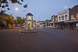
Bundanoon is a town in the Southern Highlands of New South Wales, Australia, in Wingecarribee Shire, on Gandangarra and Dharawal Country. It is an Aboriginal name meaning "place of deep gullies" and was formerly known as Jordan's Crossing. Bundanoon is colloquially known as Bundy/Bundi.

<span class="mw-page-title-main">Bowral</span> Town in New South Wales, Australia

Bowral is the largest town in the Southern Highlands of New South Wales, Australia, about ninety minutes southwest of Sydney. It is the main business and entertainment precinct of the Wingecarribee Shire and Highlands.

<span class="mw-page-title-main">Berrima, New South Wales</span> Town in New South Wales, Australia

Berrima is a historic village in the Southern Highlands of New South Wales, Australia, in Wingecarribee Shire. The village, once a major town, is located on the Old Hume Highway between Sydney and Canberra. It was previously known officially as the Town of Berrima. It is close to the three major towns of the Southern Highlands: Mittagong, Bowral and Moss Vale.

<span class="mw-page-title-main">Mittagong</span> Town in New South Wales, Australia

Mittagong is a town located in the Southern Highlands of New South Wales, Australia, in Wingecarribee Shire. The town acts as the gateway to the Southern Highlands when coming from Sydney. Mittagong is situated at an elevation of 635 metres (2,083 ft). The town is close to Bowral, Berrima, Moss Vale and the Northern Villages such as Yerrinbool and Colo Vale. Moreover, Mittagong is home to many wineries of the Southern Highlands which has been a recent growing wine and cellar door region.

<span class="mw-page-title-main">Moss Vale railway station</span> Railway station in New South Wales, Australia

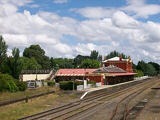
Moss Vale railway station is a heritage-listed railway station on the Main Southern line in New South Wales, Australia. It serves the town of Moss Vale. It opened on 2 December 1867 as Sutton Forest, being renamed in 1877. It was added to the New South Wales State Heritage Register on 2 April 1999.

<span class="mw-page-title-main">Sutton Forest, New South Wales</span> Town in New South Wales, Australia

Sutton Forest is a small village in the Southern Highlands, New South Wales, Australia in Wingecarribee Shire. It is located 5 km southwest of Moss Vale on the Illawarra Highway. Sutton Forest was originally granted, then owned by Navy Chief officer, Captain John Nicholson who recently immigrated from Scotland to Australia. This privately owned estate was originally 700 acres, this is where John Nicholson lived and died.

<span class="mw-page-title-main">Wingecarribee Shire</span> Local government area in New South Wales, Australia

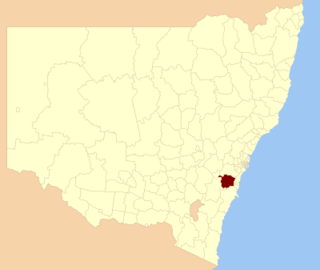
Wingecarribee Shire is the local government area of the Southern Highlands in the state of New South Wales, Australia. The Wingecarribee Shire is around 110 kilometres (70 mi) southwest of Sydney and is part of regional Capital Country and to some extent can be considered part of the Southern Tablelands.

<span class="mw-page-title-main">Fitzroy Falls, New South Wales</span> Place in New South Wales, Australia

Fitzroy Falls is a village in the Wingecarribee Shire, located within the Southern Highlands region of New South Wales, Australia. The locality was known as Yarrunga, but was renamed after the 81-metre (266 ft) waterfall.

Bong Bong was a small township in Wingecarribee Shire, New South Wales, Australia. It is also the name for the surrounding parish. It is within the Southern Highlands.

Bowral is a town in the Southern Highlands of New South Wales, Australia. It has a history spanning nearly 200 years.

<span class="mw-page-title-main">Cecil Hoskins Nature Reserve</span> Protected area in New South Wales, Australia

The Cecil Hoskins Nature Reserve is a protected nature reserve located in the Southern Highlands area of New South Wales, Australia. The 46-hectare (110-acre) reserve is situated between the towns of Bowral and Moss Vale and is known for bird watching.

<span class="mw-page-title-main">Argyle Street railway bridge, Moss Vale</span> Bridge in New South Wales, Australia

The Argyle Street railway bridge is a heritage-listed railway bridge on the Main Southern railway line (146.037 km) at Moss Vale, Wingecarribee Shire, New South Wales, Australia. It was designed and built by the New South Wales Government Railways in 1914 with steel supplied by Dorman Long of Middlesbrough, England. The property is owned by Transport Asset Holding Entity, an agency of the Government of New South Wales. It was added to the New South Wales State Heritage Register on 2 April 1999.

<span class="mw-page-title-main">Throsby Park</span> Historic site in New South Wales, Australia

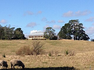
Throsby Park is a heritage-listed homestead at Church Road, Moss Vale, Wingecarribee Shire, New South Wales, Australia. It was built from 1820 to 1836. The property is owned by the Historic Houses Trust of New South Wales, but is leased to banker Tim Throsby of Barclays, a descendant of the original owners. It was added to the New South Wales State Heritage Register on 2 April 1999.

White Horse Inn is a heritage-listed former residence, inn, bank and restaurant at Market Street, Berrima, Wingecarribee Shire, New South Wales, Australia. It was built from 1834 to 1850 by Edward Davies. It is also known as Commercial Bank of Australia, Rosebank, Oldbury's Inn, Holsberry Inn, Mail Coach Inn, and Royal Mail Coach Inn. It was added to the New South Wales State Heritage Register on 2 April 1999.

<span class="mw-page-title-main">St Francis Xavier's Roman Catholic Church, Berrima</span> Church in New South Wales, Australia

St Francis Xavier's Roman Catholic Church is a heritage-listed Catholic church at Hume Highway, Berrima, Wingecarribee Shire, New South Wales, Australia. It was designed by Augustus Pugin and built from 1849 to 1851 by William Munro. Originally known as St. Scholastica's Church, it is used by the Parish of St. Paul, administered by the Pauline Fathers, and located in the Diocese of Wollongong. It was added to the New South Wales State Heritage Register on 25 January 2008.

<span class="mw-page-title-main">Berrima Post Office</span> Historic site in New South Wales, Australia

Berrima Post Office is a heritage-listed post office at Argyle Street, Berrima, Wingecarribee Shire, New South Wales, Australia. It was built in 1886 by R. N. Matthews. It was added to the New South Wales State Heritage Register on 2 April 1999.

<span class="mw-page-title-main">Holy Trinity Anglican Church, Berrima</span> Church in New South Wales, Australia

Holy Trinity Anglican Church is a heritage-listed Anglican church at Argyle Street, Berrima, Wingecarribee Shire, New South Wales, Australia. It was designed by Edmund Blacket and built from 1849. The property is owned by the Anglican Church Property Trust. It was added to the New South Wales State Heritage Register on 2 April 1999.

Berrima Inn is a heritage-listed residence and former inn, cafe, craft shop and restaurant at Jellore Street, Berrima, Wingecarribee Shire, New South Wales, Australia. It was built by Brian McMahon. It is also known as McMahon's Inn. It was added to the New South Wales State Heritage Register on 2 April 1999.

<span class="mw-page-title-main">Christ Church, Bong Bong</span> Church in New South Wales, Australia

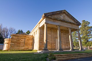
Christ Church is a heritage-listed Anglican church located on Bong Bong Road, Bong Bong, in the Wingecarribee Shire local government area of New South Wales, Australia. It was built in 1845 at the behest of Charles Throsby, possibly by convict labour. The design of the church has been attributed to John Verge. The church site includes an associated cemetery. It was added to the New South Wales State Heritage Register on 7 April 2000.

References

  1. Australian Bureau of Statistics (28 June 2022). "Moss Vale (urban centre and locality)". Australian Census 2021.  OOjs UI icon edit-ltr-progressive.svg
  2. "Moss Vale". Walkabout. John Fairfax . Retrieved 26 May 2007.
  3. "Throsby Park Historic Site". Department of Environment and Climate Change. Archived from the original on 30 August 2007. Retrieved 25 May 2007.
  4. Nairn, Bede. "Belmore, fourth Earl of (1835–1913)". Australian Dictionary of Biography . Australian National University . Retrieved 25 May 2007.
  5. "Past & Present Moss Vale – History to 1860". The Southern Highlands of New South Wales. Retrieved 25 May 2007.
  6. "Climate statistics for Moss Vale AWS". Bureau of Meteorology. Retrieved 29 November 2020.
  7. "Throsby Park Historic Site". New South Wales State Heritage Register . Department of Planning & Environment. H01008. Retrieved 18 May 2018. CC BY icon.svg Text is licensed by State of New South Wales (Department of Planning and Environment) under CC-BY 4.0 licence .
  8. "Moss Vale Railway Station and yard group". New South Wales State Heritage Register . Department of Planning & Environment. H01200. Retrieved 18 May 2018. CC BY icon.svg Text is licensed by State of New South Wales (Department of Planning and Environment) under CC-BY 4.0 licence .
  9. "Moss Vale rail underbridge over Argyle Street". New South Wales State Heritage Register . Department of Planning & Environment. H01049. Retrieved 18 May 2018. CC BY icon.svg Text is licensed by State of New South Wales (Department of Planning and Environment) under CC-BY 4.0 licence .
  10. "Oldbury Farm". New South Wales State Heritage Register . Department of Planning & Environment. H00488. Retrieved 18 May 2018. CC BY icon.svg Text is licensed by State of New South Wales (Department of Planning and Environment) under CC-BY 4.0 licence .
  11. "2021 Moss Vale, Census All persons QuickStats". Australian Bureau of Statistics. Retrieved 20 August 2022.
  12. Australian Bureau of Statistics (27 June 2017). "Moss Vale (State Suburb)". 2016 Census QuickStats. Retrieved 11 July 2017. OOjs UI icon edit-ltr-progressive.svg
  13. Authority, The Australian Communications and Media (31 August 2017). "Search for broadcasters by postcode". Acma.gov.au. Retrieved 9 December 2017.
  14. "ABC Television (Australian Broadcasting Corporation)". Abc.net.au. Retrieved 9 December 2017.
  15. "SBS Transmissions". Sbs.com.au. Retrieved 9 December 2017.
  16. "Tom Green". Australian Prints + Printmaking. Centre for Australian Art. Retrieved 9 August 2015.

Commons-logo.svg Media related to Moss Vale, New South Wales at Wikimedia Commons