Related Research Articles

The M25 or London Orbital Motorway is a major road encircling most of Greater London. The 117-mile (188-kilometre) motorway is one of the most important roads in the UK and one of the busiest. Margaret Thatcher opened the final section in 1986, making the M25 the longest ring road in Europe upon opening. The Dartford Crossing completes the orbital route but is not classed as motorway; it is classed as a trunk road and designated as the A282. In some cases, including notable legal contexts such as the Communications Act 2003, the M25 is used as a de facto alternative boundary for Greater London.

Speed limits on road traffic, as used in most countries, set the legal maximum speed at which vehicles may travel on a given stretch of road. Speed limits are generally indicated on a traffic sign reflecting the maximum permitted speed, expressed as kilometres per hour (km/h) or miles per hour (mph) or both. Speed limits are commonly set by the legislative bodies of national or provincial governments and enforced by national or regional police and judicial authorities. Speed limits may also be variable, or in some places nonexistent, such as on most of the Autobahnen in Germany.

An intelligent transportation system (ITS) is an advanced application which aims to provide innovative services relating to different modes of transport and traffic management and enable users to be better informed and make safer, more coordinated, and 'smarter' use of transport networks.

The M1 motorway connects London to Leeds, where it joins the A1(M) near Aberford, to connect to Newcastle. It was the first inter-urban motorway to be completed in the UK; the first motorway in the country was the Preston Bypass, which later became part of the M6.

The M4, originally the London-South Wales Motorway, is a motorway in the United Kingdom running from west London to southwest Wales. The English section to the Severn Bridge was constructed between 1961 and 1971; the Welsh element was largely complete by 1980, though a non-motorway section around Briton Ferry bridge remained until 1993. On the opening of the Second Severn Crossing in 1996, the M4 was rerouted over it.

Traffic signs or road signs are signs erected at the side of or above roads to give instructions or provide information to road users. The earliest signs were simple wooden or stone milestones. Later, signs with directional arms were introduced, for example the fingerposts in the United Kingdom and their wooden counterparts in Saxony.

The A14 is a major trunk road in England, running 127 miles (204 km) from Catthorpe Interchange, a major intersection at the southern end of the M6 and junction 19 of the M1 in Leicestershire to the Port of Felixstowe, Suffolk. The road forms part of the unsigned Euroroutes E24 and E30. It is the busiest shipping lane in East Anglia carrying anything from cars to large amounts of cargo between the UK and Mainland Europe.

The A12 is a major road in Eastern England. It runs north-east/south-west between London and the coastal town of Lowestoft in the north-eastern corner of Suffolk, following a similar route to the Great Eastern Main Line until Ipswich. A section of the road between Lowestoft and Great Yarmouth became part of the A47 in 2017. Between the junctions with the M25 and the A14, the A12 forms part of the unsigned Euroroute E30. Unlike most A roads, this section of the A12, together with the A14 and the A55, has junction numbers as if it were a motorway.

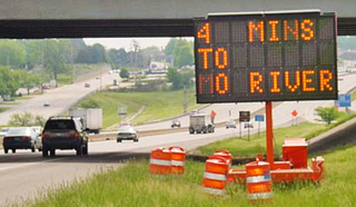
A variable-message sign or message board, often abbreviated VMS, VMB, CMS, or DMS, and in the UK known as a matrix sign, is an electronic traffic sign often used on roadways to give travelers information about special events. Such signs warn of traffic congestion, accidents, incidents such as terrorist attacks, AMBER/Silver/Blue Alerts, roadwork zones, or speed limits on a specific highway segment. In urban areas, VMS are used within parking guidance and information systems to guide drivers to available car parking spaces. They may also ask vehicles to take alternative routes, limit travel speed, warn of duration and location of the incidents, inform of the traffic conditions, or display general public safety messages.

A dual carriageway (BrE) or a divided highway (AmE) is a class of highway with carriageways for traffic travelling in opposite directions separated by a central reservation (BrE) or median (AmE). Roads with two or more carriageways which are designed to higher standards with controlled access are generally classed as motorways, freeways, etc., rather than dual carriageways.

A limited-access road, known by various terms worldwide, including limited-access highway, dual-carriageway, expressway, and partial controlled-access highway, is a highway or arterial road for high-speed traffic which has many or most characteristics of a controlled-access highway, including limited or no access to adjacent property, some degree of separation of opposing traffic flow, use of grade separated interchanges to some extent, prohibition of slow modes of transport, such as bicycles, horse-drawn vehicles or ridden horses, or self-propelled agricultural machines; and very few or no intersecting cross-streets or level crossings. The degree of isolation from local traffic allowed varies between countries and regions. The precise definition of these terms varies by jurisdiction.

A controlled-access highway is a type of highway that has been designed for high-speed vehicular traffic, with all traffic flow—ingress and egress—regulated. Common English terms are freeway, motorway, and expressway. Other similar terms include throughway or thruway and parkway. Some of these may be limited-access highways, although this term can also refer to a class of highways with somewhat less isolation from other traffic.
A smart work zone or intelligent work zone refers to a site-specific configuration of traffic control technology deployed within a roadway work zone to increase the safety of construction workers, provide "real-time" travel information, and efficiently route motorists through a work zone. Smart work zones reduce the dependency on human "flaggers" and make the work zone safer for roadway workers.

A gantry is a traffic sign assembly in which signs are mounted or railway signals are supported on an overhead support. They also often contain the apparatus for traffic monitoring systems and cameras, or open road tolling systems.

Active traffic management is a method of increasing peak capacity and smoothing traffic flows on busy major highways. Techniques include variable speed limits, hard-shoulder running and ramp-metering controlled by overhead variable message signs. It has been implemented in several countries, including Germany, the United Kingdom, Canada and the United States.
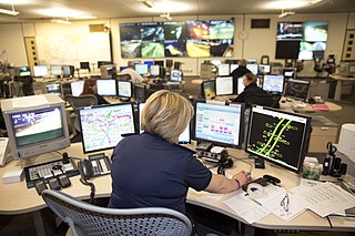
The advanced traffic management system (ATMS) field is a primary subfield within the intelligent transportation system (ITS) domain, and is used in the United States. The ATMS view is a top-down management perspective that integrates technology primarily to improve the flow of vehicle traffic and improve safety. Real-time traffic data from cameras, speed sensors, etc. flows into a transportation management center (TMC) where it is integrated and processed, and may result in actions taken with the goal of improving traffic flow. The National ITS Architecture defines the following primary goals and metrics for ITS:

An advisory speed limit is a speed recommendation by a governing body, used when it may be non-obvious to the driver that the safe speed is below the legal speed. It is a posting which either approximates the Basic Speed Law or rule or is based on a maximum g-force exerted at a specific speed. Advisory speed limits are often set in areas with many pedestrians, such as in city centres and outside schools, and on difficult stretches of roads, such as on tight corners or through roadworks. While travelling above the advisory speed limit is not illegal per se, it may be negligence per se and liability for any collisions that occur as a result of traveling above the limit can be placed partially or entirely on the person exceeding the advisory speed limit.

Road signs in Thailand are standardized road signs similar to those used in other nations but much of it resembles road signage systems used in South American countries with certain differences, such as using a blue circle instead of a red-bordered white circle to indicate mandatory actions. Until the early 1980s, Thailand closely followed American, European, Australian, and Japanese practices in road sign design, with diamond-shaped warning signs and circular restrictive signs to regulate traffic. The Department of Railway maintains a standard on the typeface used in the sign, with custom made type for Thai text, unofficially named "Thang Luang" (อักษรทางหลวง) and a small derivation of FHWA Series fonts typeface, which is used on American road signage, for Latin text. In most Bangkok Metropolitan Area's routes, TS Lopburi is still used.

IRIS is an open-source Advanced Traffic Management System (ATMS) software project developed by the Minnesota Department of Transportation. It is used by transportation agencies to monitor and manage interstate and highway traffic. IRIS uses the GPL license.
A smart motorway, also known in Scotland as an intelligent transport system, is a section of motorway in the United Kingdom that employs active traffic management (ATM) techniques to increase capacity through the use of MIDAS technology including variable speed limits and occasionally hard shoulder running and ramp metering at busy times. They were developed at the turn of the 21st century as a cost-effective alternative to traditional carriageway widening, with intended benefits ranging from more reliable journey times to lower vehicle emissions. However, despite the risk of a collision occurring between two moving vehicles being found to be decreased, there has been an acknowledged rise in the incidence of collisions involving vehicles where at least one was stationary in the first few years following the widespread removal of the hard shoulder on the country's busiest sections of motorway. Smart motorways garnered intense criticism from politicians, police representatives and motoring organisations, particularly from 2020 onwards, after a surge in near miss incidents and dozens of fatalities were revealed, and as of April 2023, no new smart motorways will be built.
References
- 1 2 "Cost effectiveness of MIDAS". Highways Agency. Archived from the original on 8 October 2007. Retrieved 7 January 2007.
- ↑ "A14 Corridor Traffic Management Scheme". Highways Agency. Archived from the original on 5 June 2011. Retrieved 18 July 2011.