Motu Nui

Last updated
Motu Nui, with the smaller Motu Iti and the sea stack of Motu Kao Kao. Picture taken September 2018, from Orongo on the Rano Kau volcano, around 250 meters (820 feet) above sea level. Easter Island 11.jpg
Motu Nui, with the smaller Motu Iti and the sea stack of Motu Kao Kao. Picture taken September 2018, from Orongo on the Rano Kau volcano, around 250 meters (820 feet) above sea level.

Motu Nui (large island in the Rapa Nui language) is the largest of three islets just south of Easter Island and is the westernmost place in Chile. All three islets have seabirds, but Motu Nui was also an essential location for the Tangata manu ("Bird Man") cult which was the island religion between the moai era and the Christian era (the people of the island were converted to Roman Catholicism in the 1860s). Motu Nui is the summit of a large volcanic mountain which rises over 2,000 meters from the sea bed. It measures 3.9 hectares in land area and is the largest of the five satellite islets of Easter island. It is one of three islands that is closest to Point Nemo, the place in the ocean that is farthest from land, the other two being Ducie Island, one of the Pitcairn Islands, and Maher Island in Antarctica. [1] [2]
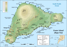
Map including Motu Nui (lower left) Easter Island map-en.svg
Map including Motu Nui (lower left)

The ritual of the "Bird Man" cult was a competition to collect the first egg of the manutara. This took place starting from Motu Nui where the Hopu (representatives from each clan) waited for the sooty terns to lay their first eggs of the season. The Hopu who seized the first egg raced to swim back to Easter Island, climbed the cliffs to Orongo and presented the egg to their sponsor in front of the judges at Orongo. This gave their sponsor the title of Tangata manu and great power on the island for a year. Many Hopu were killed by sharks or by falling. The winning clan gained certain rights, including the collecting of eggs and young birds from the islets.

Motu means "island" in Rapa Nui language, and there are two smaller motus located nearby: Motu Kao Kao (a sea stack, rising around 20 meters (65 feet) above sea level) and Motu Iti (near Motu Nui).

Motu Nui was scientifically surveyed by the Routledge expedition of 1914, which reported that six other varieties of seabirds nested there in addition to the sooty tern. They explored two caves on Motu Nui, in one of which the Hopu used to stay while waiting for the first egg of the season, and the other used to contain Moai Maea "The Boundary of the Land," a small moai that had already been taken to the Pitt Rivers Museum in Oxford, England.

Although the Tangata Manu cult's rituals have long since been discontinued (the last competition known to have taken place in 1888), current visitors to Rapa Nui often enjoy the beauty of the Motus via small boat excursions from Hanga Roa, the island's only town. The diving in the sea between Motu Nui and Kau Kau is exceptional, and it is a highly sought-after scuba diving location for dive enthusiasts from around the world. Once heavily populated with sharks, the coastal waters of Rapa Nui are now much safer, due in large part to overfishing.

Related Research Articles

<span class="mw-page-title-main">Easter Island</span> Chilean island in the Pacific

Easter Island is an island and special territory of Chile in the southeastern Pacific Ocean, at the southeasternmost point of the Polynesian Triangle in Oceania. The island is most famous for its nearly 1,000 extant monumental statues, called moai, which were created by the early Rapa Nui people. In 1995, UNESCO named Easter Island a World Heritage Site, with much of the island protected within Rapa Nui National Park.

<span class="mw-page-title-main">Sooty tern</span> Species of bird

The sooty tern is a seabird in the family Laridae. It is a bird of the tropical oceans, returning to land only to breed on islands throughout the equatorial zone.

<span class="mw-page-title-main">Moai</span> Monolithic human figures on Easter Island

Moai or moʻai are monolithic human figures carved by the Rapa Nui people on Rapa Nui in eastern Polynesia between the years 1250 and 1500. Nearly half are still at Rano Raraku, the main moai quarry, but hundreds were transported from there and set on stone platforms called ahu around the island's perimeter. Almost all moai have overly large heads, which comprise three-eighths the size of the whole statue. They have no legs. The moai are chiefly the living faces of deified ancestors. The statues still gazed inland across their clan lands when Europeans first visited the island in 1722, but all of them had fallen by the latter part of the 19th century. The moai were toppled in the late 18th and early 19th centuries, possibly as a result of European contact or internecine tribal wars.

<span class="mw-page-title-main">Rapa Nui people</span> Polynesian inhabitants of Easter Island

The Rapa Nui are the indigenous Polynesian peoples of Easter Island. The easternmost Polynesian culture, the descendants of the original people of Easter Island make up about 60% of the current Easter Island population and have a significant portion of their population residing in mainland Chile. They speak both the traditional Rapa Nui language and the primary language of Chile, Spanish. At the 2017 census there were 7,750 island inhabitants—almost all living in the village of Hanga Roa on the sheltered west coast.

<span class="mw-page-title-main">Rano Raraku</span> Volcanic crater in Easter Island

Rano Raraku is a volcanic crater formed of consolidated volcanic ash, or tuff, and located on the lower slopes of Terevaka in the Rapa Nui National Park on Easter Island in Chile. It was a quarry for about 500 years until the early eighteenth century, and supplied the stone from which about 95% of the island's known monolithic sculptures (moai) were carved. Rano Raraku is a visual record of moai design vocabulary and technological innovation, where 887 moai remain. Rano Raraku is in the World Heritage Site of Rapa Nui National Park and gives its name to one of the seven sections of the park.

<span class="mw-page-title-main">Isla Salas y Gómez</span> Uninhabited Pacific island of Chile

Isla Salas y Gómez, also known as Isla Sala y Gómez, is a small uninhabited Chilean island in the Pacific Ocean. It is sometimes considered the easternmost point in the Polynesian Triangle.

<span class="mw-page-title-main">Tangata manu</span>

The Tangata manu was the winner of a traditional ritual competition on Rapa Nui to collect the first sooty tern egg of the season from the nearby islet of Motu Nui, swim back to Rapa Nui, and climb the sea cliffs of Rano Kau to the clifftop village of Orongo.

<i>Onychoprion</i> Genus of birds

Onychoprion, the "brown-backed terns", is a genus of seabirds in the family Laridae. The genus name is from Ancient Greek onux, "claw" or "nail", and prion, "saw".

<span class="mw-page-title-main">Rapa Nui National Park</span> World Heritage Site in Easter Island

Rapa Nui National Park is a national park and UNESCO World Heritage Site located on Easter Island, Chile. Rapa Nui is the Polynesian name of Easter Island; its Spanish name is Isla de Pascua. The island is located in the southeastern Pacific Ocean, at the southeastern extremity of the Polynesian Triangle. The island was taken over by Chile in 1888. Its fame and World Heritage status arise from the 887 extant stone statues known by the name "moai", whose creation is attributed to the early Rapa Nui people who inhabited the island starting between 300 and 1200 AD. Much of the island has been declared as Rapa Nui National Park which, on 22 March 1996, UNESCO designated a World Heritage Site under cultural criteria (i), (iii), & (v). Rapa Nui National Park is now under the administrative control of the Ma´u Henua Polynesian Indigenous Community, which is the first autonomous institute on the island. The indigenous Rapa Nui people have regained authority over their ancestral lands and are in charge of the management, preservation and protection of their patrimony. On the first of December 2017, the ex-President Michelle Bachelet returned ancestral lands in the form of the Rapa Nui National Park to the indigenous people. For the first time in history, the revenue generated by the National Park is invested in the island and used to conserve the natural heritage.

<span class="mw-page-title-main">Makemake (deity)</span> Deity in the Rapa Nui mythology of Easter Island

Makemake in the Rapa Nui mythology of Easter Island is the creator of humanity, the god of fertility and the chief god of the "Tangata manu" or bird-man sect. He appeared to be the local form, or name, of the old Polynesian god Tane. He had no wife.

<span class="mw-page-title-main">Rapa Nui mythology</span> Mythology of culture on Easter Island

Rapa Nui mythology, also known as Pascuense mythology or Easter Island mythology, refers to the native myths, legends, and beliefs of the Rapa Nui people of Easter Island in the south eastern Pacific Ocean.

<span class="mw-page-title-main">Motu Iti (Rapa Nui)</span> Islet near Easter Island

Motu Iti, or Little island in the Rapa Nui language, is a small uninhabited islet near Motu Nui, about a mile from Rano Kau on the south western corner of Easter Island, a Chilean island in the Pacific. It has a land area of 1.6 hectares, which makes it the second largest of the five satellite islands of Easter Island, after Motu Nui.

<span class="mw-page-title-main">Hoa Hakananai'a</span> Statue from Easter Island

Hoa Hakananai'a is a moai, a statue from Easter Island. It was taken from Orongo, Easter Island in 1868 by the crew of a British ship and is now in the British Museum in London.

<span class="mw-page-title-main">Orongo</span> Stone village and ceremonial center on Easter Island

Orongo is a stone village and ceremonial center at the southwestern tip of Rapa Nui. It consists of a collection of low, sod-covered, windowless, round-walled buildings with even lower doors positioned on the high south-westerly tip of the large volcanic caldera called Rano Kau. Below Orongo on one side a 300-meter barren cliff face drops down to the ocean; on the other, a more gentle but still very steep grassy slope leads down to a freshwater marsh inside the high caldera.

<span class="mw-page-title-main">Totora (plant)</span> Species of plant

Totora is a subspecies of the giant bulrush sedge. It is found in South America, notably on Lake Titicaca, the middle coast of Peru and on Easter Island in the Pacific Ocean. The genus Schoenoplectus is closely related to Scirpus and sometimes included therein. This plant can reach a height of 6 m (20 ft) and commonly reaches 4 m (13 ft). The word totora comes from the Quechua language.

<span class="mw-page-title-main">Anakena</span> Beach on Easter Island

Anakena is a white coral sand beach in Rapa Nui National Park on Rapa Nui, a Chilean island in the Pacific Ocean. Anakena has two ahus; Ahu-Ature has a single moai and Ahu Nao-Nao has seven, two of which have deteriorated. It also has a palm grove and a car park.

<span class="mw-page-title-main">Rano Kau</span> Dormant volcano in Easter Island

Rano Kau is a 324 m (1,063 ft) tall dormant volcano that forms the southwestern headland of Easter Island, a Chilean island in the Pacific Ocean. It was formed of basaltic lava flows in the Pleistocene with its youngest rocks dated at between 150,000 and 210,000 years ago.

<span class="mw-page-title-main">Viña Anakena</span>

Anakena is a privately owned winery based in the Alto Cachapoal area of the Rapel Valley of Chile. It produces a variety of styles. In September 2015 Anakena was bought by Accolade Wines for $30 million.

<span class="mw-page-title-main">Geography of Easter Island</span> Overview of the Geography of Easter Island

Easter Island is one of the world's most isolated inhabited islands. Its closest inhabited neighbours are the Chilean Juan Fernandez Islands, 1,850 km (1,150 mi) to the east, with approximately 850 inhabitants. The nearest continental point lies in central Chile near Concepción, at 3,512 kilometres (2,182 mi). Easter Island's latitude is similar to that of Caldera, Chile, and it lies 3,510 km (2,180 mi) west of continental Chile at its nearest point. Isla Salas y Gómez, 415 km (258 mi) to the east, is closer but is uninhabited. The Tristan da Cunha archipelago in the southern Atlantic competes for the title of the most remote island, lying 2,430 km (1,510 mi) from Saint Helena island and 2,816 km (1,750 mi) from the South African coast.

<span class="mw-page-title-main">Ana Kai Tangata</span> Sea cave on Easter Island, Chile

Ana Kai Tangata is a sea cave in Easter Island that contains rock art of terns on its ceiling. It is located near Mataveri, and the cave opens up directly to the incoming surf. The cave is accessible and one of the most visited caves in Easter Island.

References

  1. "Where is Point Nemo?".
  2. "Point Nemo, revisited".

27°12′05″S109°27′10″W / 27.20139°S 109.45278°W / -27.20139; -109.45278