
The Forbidden Plateau is a small, hilly plateau in the east of the Vancouver Island Ranges in British Columbia, northwest of Comox Lake roughly between Mount Albert Edward to the southwest and Mount Washington to the northeast.

Strathcona Provincial Park is the oldest provincial park in British Columbia, Canada, and the largest on Vancouver Island. Founded in 1911, the park was named for Donald Alexander Smith, 1st Baron Strathcona and Mount Royal, a wealthy philanthropist and railway pioneer. It lies within the Strathcona Regional District. The Clayoquot Sound Biosphere Reserve, established in 2000, includes three watersheds in the western area of the park.

Strathcona-Westmin Provincial Park is a Class B provincial park located at the southern extremity of Buttle Lake on Vancouver Island in British Columbia, Canada. The park was separated out from Strathcona Provincial Park by BC Parks in 1987 so that mining operations could proceed within park boundaries. Strathcona-Westmin is expected to be reabsorbed into Strathcona Provincial Park once mining operations cease.

BC Parks is an agency of the British Columbia Ministry of Environment and Climate Change Strategy that manages all of the, as of 2020, 1,035 provincial parks and other conservation and historical properties of various title designations within the province's Parks oversaw of the British Columbia Parks and Protected Areas System. The Lieutenant Governor-in-Council created the agency on March 1, 1911, through the Strathcona Park Act. The agency is charged with a dual role of preserving the ecological and historical integrity of the places entrusted to its management, while also making them available and accessible for public use and enjoyment.
Elkhorn Mountain is a mountain located in the Elk River Mountains of the Vancouver Island Ranges of British Columbia, Canada. At 2,194 m (7,198 ft), it is the second highest peak on Vancouver Island, second only to the nearby Golden Hinde which lies 15 km (9 mi) to the south. The mountain is located in the 2,500 km² Strathcona Provincial Park, 24 km (15 mi) east of Gold River.

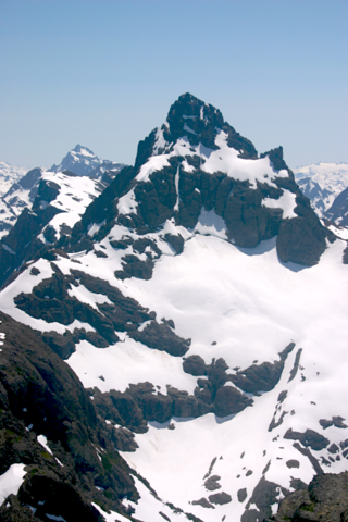
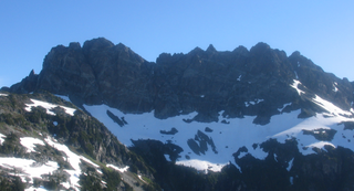
Mount Colonel Foster is a mountain located on Vancouver Island in Strathcona Regional District, British Columbia, Canada. At 2,135 metres (7,005 ft), it is the fourth highest peak on the island. It is one of the nine Island Qualifiers.
Mount Celeste is the unofficial name for a mountain located on Vancouver Island, British Columbia. It shares the name Celeste with two peaks in the Cariboo region of the BC Interior. Within the boundaries of Strathcona Provincial Park, this peak lies at the north end of Rees Ridge. Iceberg Peak lies at the south end of this ridge.
Iceberg Peak is a mountain located on Vancouver Island, British Columbia, Canada. Within the boundaries of Strathcona Provincial Park, this peak lies at the south end of Rees Ridge. Mount Celeste lies at the north end of this ridge.
Crown Mountain, sometimes called Ellison Peak, is a mountain located in Strathcona Provincial Park on Vancouver Island in British Columbia.
Mount George V is a mountain located in Strathcona Provincial Park on Vancouver Island in British Columbia. This peak is located 3.2 km (2 mi) south of Mount Albert Edward. Mount Frink and Castlecrag Mountain are within 2 km (1 mi) to the northeast. Its first ascent may have been by surveyors in the 1930s.
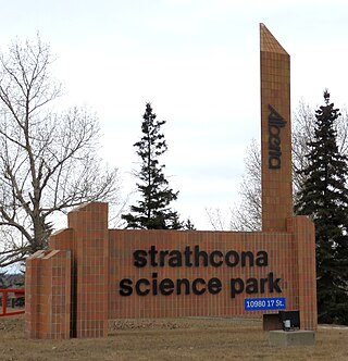
Strathcona Science Provincial Park is a provincial park in Alberta, Canada, located between Edmonton and Sherwood Park, south of the Yellowhead Highway and west of Anthony Henday Drive.

The Red Pillar is a mountain on Vancouver Island, British Columbia, Canada, located 33 km (21 mi) southwest of Courtenay and 17 km (11 mi) south of Mount Albert Edward.
Mount Rosseau is a mountain on Vancouver Island, British Columbia, Canada, located 43 km (27 mi) southwest of Courtenay and 23 km (14 mi) south of Mount Albert Edward. It is the highest summit of the Septimus-Rosseau massif. The most western summit of the massif is Mount Septimus.

Mount Septimus is the western summit of a jagged mountain on Vancouver Island, British Columbia, Canada, located 50 km (31 mi) southeast of Gold River and 10 km (6 mi) south of Buttle Lake. It contains a huge glacier on the north flank. The highest peak on the massif is Mount Rosseau, located 600 m (1,969 ft) to the west.

Mount Tom Taylor is a mountain on Vancouver Island, British Columbia, Canada, located 41 km (25 mi) northeast of Tofino and 27 km (17 mi) southwest of Mount Albert Edward. This mountain is composed of granite, which is nearly unique in Strathcona Provincial Park. Several multi-pitch alpine climbing routes have been established on its steep SE flanks.
Jack Shark Lake is a lake located on Vancouver Island on the west side of Augerpoint Mountain west of Mount Albert Edward in Strathcona Provincial Park.
Gem Lake is a lake located on Vancouver Island north east of Mount Albert Edward on the east side of Buttle Lake, in Strathcona Provincial Park.
Charity Lake is a lake located on Vancouver Island is an expansion of Ralph River south of Mount Albert Edward in Strathcona Provincial Park,
Sunrise Lake is a lake on Vancouver Island north of Mount Albert Edward near the head of the Oyster River, in Strathcona Provincial Park.


