
Mount Ball is a mountain located on the Continental Divide, on the borders of Banff and Kootenay national parks in Western Canada. Mt. Ball is the highest peak of the Ball Range in the Canadian Rockies.
Beatrice Peak is a peak located on the Continental Divide on the border of Banff and Kootenay National Parks, between Stanley Peak and Mount Ball. The mountain was named in 1912 by the Alpine Club of Canada after Beatrice Shultz who climbed the mountain that year.
The Waputik Range lies west of the upper Bow Valley, east of Bath Creek, and south of Balfour Creek in the Canadian Rockies. "Waputik" means "white goat" in Stoney. The range was named in 1884 by George Mercer Dawson of the Geological Survey of Canada. The President Range lies within the Waputik Range.
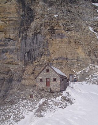
The Abbot Pass hut was an alpine hut located at an altitude of 2,925 metres (9,596 ft) in Abbot Pass in the Rocky Mountains in Alberta, Canada. It was nestled between Mount Victoria and Mount Lefroy, straddling the Great Divide, which, in this region, defines the boundary between Banff National Park in Alberta and Yoho National Park in British Columbia. While close to the border, the hut lay entirely in Banff National Park, and was the second-highest permanently habitable structure in Canada. The hut was maintained by the Alpine Club of Canada.

Mount Allen is a mountain in the Canadian Rockies, on the Continental Divide, which forms the provincial boundary between British Columbia and Alberta in this region. J. Monroe Thorington named this mountain for Samuel Evans Stokes Allen in 1924. Allen was an American cartographer who mapped this area of the Rockies in 1894–1895. Allen had named this mountain "Shappee", the Stoney language word for "six", as part of his naming of the ten mountains in the Valley of the Ten Peaks. The peak forms part of the backdrop to Moraine Lake in Banff National Park.
Mount Bishop is a mountain named in 1918 after W.A. "Billy" Bishop VC who was a Colonel and a Canadian fighter pilot awarded the Victoria Cross during World War I. It is located in the Elk Range of the Canadian Rockies and sits on the Continental Divide, which forms the British Columbia-Alberta border in this area.

Neptuak Mountain was named by Samuel E.S. Allen in 1894. "Neptuak" is the Stoney Indian word for "nine" as Neptuak Mountain is peak #9 in the Valley of the Ten Peaks. It is located on the Continental Divide, which is also the British Columbia-Alberta border in this region, and is in the Bow Range of the Park Ranges of the Canadian Rockies. The summit is a tripoint for Banff National Park, Kootenay National Park, and Yoho National Park, where the three parks share a common border.

The Clachnacudainn Range is a subrange of the Selkirk Mountains in southeastern British Columbia, Canada, located within Mount Revelstoke National Park, just northeast of Revelstoke. It was named by Arthur Wheeler in reference to the Clachnacudainn charter stone, located in Inverness, Scotland. The range is bounded by the Illecillewaet River to the south, Lake Revelstoke to the west, and Carnes and Woolsey Creeks to the north and east. The highest point in the range is Mount Coursier at 2,648 metres (8,688 ft).
Mount Barlow is located on the Continental Divide along the border of Alberta and British Columbia at the southern edge of the Freshfield Icefield in Banff National Park. It was named in 1916 by D.B. Dowling after Dr. Alfred Ernest Barlow, a cartographer with the Geological Survey of Canada who died in the 1914 Empress of Ireland disaster.

Mount Habel is a 3,073-metre (10,082-foot) mountain summit located in Banff National Park on the Continental Divide along the border of Alberta and British Columbia in the Waputik Mountains, part of the Canadian Rockies. It was named in 1986 after Jean Habel. Jean Habel was a German geographer who explored the Canadian Rockies and in 1897 was the first to set foot on the Wapta Icefield which surrounds Mount Habel.

Mount Bosworth is located in the Canadian Rockies on the border of Alberta and British Columbia. The mountain is situated immediately northwest of Kicking Horse Pass and straddles the shared border of Banff National Park with Yoho National Park. It was named in 1903 after George Morris Bosworth, an executive and long-time employee of the Canadian Pacific Railway.

The Ramparts are a mountain range in the Canadian Rockies. Part of the Park Ranges, they straddle the Continental Divide and lie partly within Jasper National Park in Alberta and Mount Robson Provincial Park in British Columbia.
Odaray Mountain is a 3,137-metre (10,292-foot) summit located west of Lake O'Hara in the Bow Range of Yoho National Park, in the Canadian Rockies of British Columbia, Canada. Its nearest higher peak is Mount Huber, 3.86 km (2.40 mi) to the east. The standard climbing route follows the southeast glacier and ridge starting from Elizabeth Parker hut. Pronunciation sounds like the two words "ode array".
Mount Huber is a 3,348-metre (10,984-foot) summit located two kilometres east of Lake O'Hara in the Bow Range of Yoho National Park, in the Canadian Rockies of British Columbia, Canada. The nearest higher neighbor is Mount Victoria, 1.0 km (0.62 mi) to the north-northeast on the Continental Divide. Mount Huber is a secondary summit of Mount Victoria.

Mount Schaffer is a 2,691-metre (8,829-foot) mountain summit located one kilometre (0.62 mi) southwest of Lake O'Hara in Yoho National Park, in the Bow Range of the Canadian Rockies of British Columbia, Canada. Its nearest higher peak is Mount Biddle, 3.2 km (2.0 mi) to the southeast. Mount Schaffer is situated 3.5 kilometres (2.2 mi) west of the Continental Divide, and 12 kilometres (7.5 mi) southeast of Field, British Columbia.

Mount Niles is a 2,967-metre (9,734-foot) summit located in the Waputik Range of Yoho National Park, in the Canadian Rockies of British Columbia, Canada. The nearest higher peak is Mount Daly, 1.63 km (1.01 mi) to the immediate northeast. Takakkaw Falls is situated four km to the west, the Waputik Icefield lies to the north, and Sherbrooke Lake lies to the south. Precipitation runoff from Mount Niles drains into the Yoho River and Niles Creek, both tributaries of the Kicking Horse River. Topographic relief is significant as the summit rises approximately 1,500 meters (4,920 feet) above Yoho Valley in four kilometers (2.5 mile).

Trolltinder Mountain is a 2,912-metre (9,554-foot) mountain summit located immediately west of the Continental Divide, in the Waputik Range of the Canadian Rockies in British Columbia, Canada. It is situated in Yoho National Park, with its nearest higher peak being Mount Balfour, 1.0 km (0.62 mi) to the northeast, and Fairy Lake directly below its southern slope.
Mount Onderdonk is a mountain in British Columbia named for Andrew Onderdonk. It is located in the northern Selkirk Mountains between lower Revelstoke Lake and the Wood Arm of Kinbasket Lake. The mountain is 280 miles from Vancouver, 1861 miles from Toronto and 2047 miles from Montreal. Andrew Onderdonk was a Dutch-American engineer who worked in the late 1800s building the Canadian Pacific Railway in British Columbia and in other locations. William Lowell Putnam and Roger W. Laurilla gave the mountain this name as a tribute to Onderdonk.

Narao Peak is a 2,974-metre (9,757-foot) summit located in British Columbia, Canada.

Mount Pollinger is a 2,816-metre (9,239-foot) summit in British Columbia, Canada.


