The Dennistoun Glacier is a glacier, 50 nautical miles long, draining the northern slopes of Mounts Black Prince, Royalist and Adam in the Admiralty Mountains of Victoria Land in Antarctica. It flows northwest between the Lyttelton Range and Dunedin Range, turning east on rounding the latter range to enter the sea south of Cape Scott. The coastal extremity of the glacier was charted in 1911–12 by the Northern Party, led by Victor Campbell, of the British Antarctic Expedition, 1910–13. The geographical feature lies situated on the Pennell Coast, a portion of Antarctica lying between Cape Williams and Cape Adare.

Ebbe Glacier is a tributary glacier about 60 nautical miles long, draining northwest from the Homerun Range and the Robinson Heights, and then west-northwest between the Everett Range and the Anare Mountains into Lillie Glacier, Victoria Land, Antarctica. This feature saddles with Tucker Glacier, the latter draining southeast to the Ross Sea. The glacier lies situated on the Pennell Coast, a portion of Antarctica lying between Cape Williams and Cape Adare. Robertson Glacier is a tributary glacier to Ebbe Glacier.

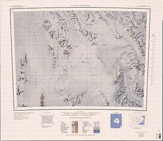
The Anare Mountains are a large group of mainly snow-covered peaks and ridges along the northern coast of Victoria Land, Antarctica. The group is bounded on the north and east by the Pacific Ocean, on the west by Lillie Glacier, and on the south by Robertson Glacier, Ebbe Glacier and Dennistoun Glacier. Kirkby Glacier, 20 miles (32 km) in length, drains the central Anare Mountains and flows northwest to the sea 3 miles (5 km) from Cape North, and just north of Arthurson Bluff, northern Victoria Land. The mountain range is situated on the Pennell Coast, a portion of Antarctica lying between Cape Williams and Cape Adare.
Lillie Glacier is a large glacier in Antarctica, about 100 nautical miles (190 km) long and 10 nautical miles (19 km) wide. It lies between the Bowers Mountains on the west and the Concord Mountains and Anare Mountains on the east, flowing to Ob' Bay on the coast and forming the Lillie Glacier Tongue.
The Greenwell Glacier is a major tributary glacier, 45 nautical miles long, draining northwest between the Mirabito Range and the Everett Range to enter Lillie Glacier below Mount Works, in northwest Victoria Land, Antarctica. This geographical feature was first mapped by the United States Geological Survey from surveys and from U.S. Navy aerial photography, 1960–63, and was so named by the Advisory Committee on Antarctic Names for Commander Martin D. Greenwell, U.S. Navy, Commander of Antarctic Squadron Six (VX-6), 1961–62. The glacier lies situated on the Pennell Coast, a portion of Antarctica lying between Cape Williams and Cape Adare.

The Usarp Mountains is a major Antarctic mountain range, lying westward of the Rennick Glacier and trending N-S for about 190 kilometres (118 mi). The feature is bounded to the north by Pryor Glacier and the Wilson Hills. Its important constituent parts include Welcome Mountain, Mount Van der Hoeven, Mount Weihaupt, Mount Stuart, Mount Lorius, Smith Bench, Mount Roberts, Pomerantz Tableland, Daniels Range, Emlen Peaks, Helliwell Hills and Morozumi Range.
The Humboldt Mountains are a group of mountains immediately west of the Petermann Ranges, forming the westernmost portion of the Wohlthat Mountains in Queen Maud Land, Antarctica.
Cape Evans is a rocky cape on the west side of Ross Island, Antarctica, forming the north side of the entrance to Erebus Bay.
Explorers Range is a large mountain range in the Bowers Mountains of Victoria Land, Antarctica, extending from Mount Bruce in the north to Carryer Glacier and McLin Glacier in the south. Named by the New Zealand Antarctic Place-Names Committee (NZ-APC) for the northern party of New Zealand Geological Survey Antarctic Expedition (NZGSAE), 1963–64, whose members carried out a topographical and geological survey of the area. The names of several party members are assigned to features in and about this range. All of the geographical features listed below lie situated on the Pennell Coast, a portion of Antarctica lying between Cape Williams and Cape Adare.
Black Glacier is a broad tributary to the Lillie Glacier flowing northeast, marking the southeast extent of the Bowers Mountains, a major mountain range situated in the geographical location of Victoria Land, Antarctica. The glacier was first mapped by the United States Geological Survey from ground surveys and from U.S. Navy air photos, 1960–62, and named by the Advisory Committee on Antarctic Names for Robert F. Black, former geologist of the University of Wisconsin, project leader for Antarctic patterned ground studies, who carried out research in the McMurdo Sound region during several summer seasons in the 1960s. The glacier lies situated on the Pennell Coast, a portion of Antarctica lying between Cape Williams and Cape Adare.
Mount Bresnahan is a flat-topped, mainly ice-free mountain, 1,630 metres (5,350 ft) high, situated along the east side of the Helliwell Hills, 6 nautical miles (11 km) north-northeast of Mount Van der Hoeven, situated in Victoria Land, Antarctica. The topographical feature was first mapped by the United States Geological Survey from surveys and from U.S. Navy air photos, 1960–63, and named by the Advisory Committee on Antarctic Names after David M. Bresnahan, a United States Antarctic Research Program biologist at McMurdo Station, Hut Point Peninsula, Ross Island, 1967–68 and 1968–69, and on the staff of the Office of Polar Programs, National Science Foundation, from 1970. The mountain lies situated on the Pennell Coast, a portion of Antarctica lying between Cape Williams and Cape Adare.
Champness Glacier is a tributary glacier, 15 nautical miles (30 km) long, draining northeast from the vicinity of Ian Peak in the Bowers Mountains and entering Lillie Glacier at Griffith Ridge, Victoria Land, Antarctica. The glacier was so named by the New Zealand Geological Survey Antarctic Expedition to northern Victoria Land, 1967–68, for G.R. Champness, field assistant with that party. The glacier lies situated on the Pennell Coast, a portion of Antarctica lying between Cape Williams and Cape Adare.
Crume Glacier is a tributary glacier, 5 nautical miles (9 km) long, flowing east to enter Ommanney Glacier near the north coast of Victoria Land, Antarctica. The geographical feature was first mapped by the United States Geological Survey from surveys and from U.S. Navy air photos, 1960–63, and named by the Advisory Committee on Antarctic Names for William R. Crume, AS1, U.S. Navy, Support Equipment Maintenance Supervisor with Squadron VX-6 at McMurdo Station, Hut Point Peninsula, Ross Island, during Operation Deep Freeze 1968. The glacier lies situated on the Pennell Coast, a portion of Antarctica lying between Cape Williams and Cape Adare.
Griffith Ridge is a rock ridge 5 nautical miles (9 km) long in the Bowers Mountains of Victoria Land, Antarctica, located just within the mouth of Champness Glacier, where the latter joins the larger Lillie Glacier. This geographical feature was first mapped by the United States Geological Survey from surveys and U.S. Navy air photos, 1960–62, and was named by the Advisory Committee on Antarctic Names for Lieutenant Harry G. Griffith, U.S. Navy, public works officer at McMurdo Station, Hut Point Peninsula, Ross Island, 1967. This ridge lies situated on the Pennell Coast, a portion of Antarctica lying between Cape Williams and Cape Adare.
Evans Névé is a large névé which nourishes Tucker Glacier, Mariner Glacier, Aviator Glacier, Rennick Glacier and Lillie Glacier in Victoria Land, Antarctica. The névé was named in honor for Edgar Evans of the ill-fated British Antarctic Expedition, 1910–13, by the Northern Party of the New Zealand Geological Survey Antarctic Expedition, 1963–64. Evans, along with Edward Adrian Wilson, Lawrence Oates and Henry Robertson Bowers, accompanied Captain Robert F. Scott to the Geographic South Pole, January 17, 1912. All five perished on the return journey after failing to beat Norwegian explorer Roald Amundsen to the 90th parallel. This glaciological feature lies situated on the Pennell Coast, a portion of Antarctica lying between Cape Williams and Cape Adare.
Everett Spur is a prominent rock spur which marks the northwest end of the Everett Range and the junction of Ebbe Glacier with Lillie Glacier, Victoria Land, Antarctica. This geographical feature was first mapped by the United States Geological Survey from surveys and U.S. Navy air photos, 1960–62, and was named by the Advisory Committee on Antarctic Names for Kaye R. Everett, a geologist at McMurdo Station, Hut Point Peninsula, Ross Island, 1967–68, and at Livingston Island, South Shetland Islands, 1968–69. This spur lies situated on the Pennell Coast, a portion of Antarctica lying between Cape Williams and Cape Adare.
George Glacier is a valley glacier in the western part of the Anare Mountains of Victoria Land, Antarctica. The glacier rises east of Mount Burch and flows northwest past Mount Kelly to Lillie Glacier Tongue on the coast. This geographical feature was first mapped by the United States Geological Survey from surveys and U.S. Navy air photos, 1960–1965, and was named by the Advisory Committee on Antarctic Names for Robert Y. George, a zoologist at McMurdo Station, Hut Point Peninsula, Ross Island, 1967–1968. The glacier is situated on the Pennell Coast, a portion of Antarctica lying between Cape Williams and Cape Adare.
Graveson Glacier is a broad north-flowing tributary to the Lillie Glacier, draining that portion of the Bowers Mountains between the Posey Range and the southern part of Explorers Range, Victoria Land, Antarctica. The geographical feature is fed by several lesser tributaries and enters Lillie Glacier via Flensing Icefall. The glacier was so named by the northern party of the New Zealand Geological Survey Antarctic Expedition, 1963–64, for F. Graveson, a mining engineer who wintered at Scott Base in 1963 and was field assistant on this expedition. The glacier lies situated on the Pennell Coast, a portion of Antarctica lying between Cape Williams and Cape Adare.
McCann Glacier is a tributary glacier which drains the east slopes of Mount Stirling in the Bowers Mountains of Antarctica, and flows east between Mount Radspinner and Markinsenis Peak into Lillie Glacier. It was mapped by the United States Geological Survey from surveys and U.S. Navy air photos, 1960–64, and was named by the Advisory Committee on Antarctic Names for Chief Utilitiesman J.M. McCann, U.S. Navy, who was a member of the McMurdo Station winter party in 1962 and took part in summer support activities, 1963–65.