Mount Everest webcam

Last updated
Everest alpenglow sunset from webcam EverestSunset.png
Everest alpenglow sunset from webcam

The Mount Everest Webcam (EWC) was activated by the EVK2Minoprio Organization at the same time as the COP 27- 2022

Contents

Features

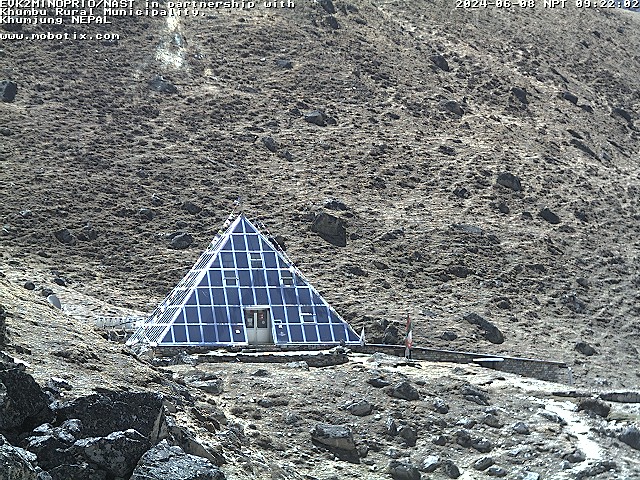
It is a webcam located on Kala Patthar, a mountain in Nepal located in front of Everest, in the Himalayas Himalaya, at an elevation of 5,675 metres (18,619 ft). The webcam capture video footage of the summit of Mount Everest and is the highest webcam in the world. [1] It was installed for the first time by Italian scientists as part of the EvK2CNR / NAST Piramide Observatory Laboratory project, [2] which had and aims to collect scientific information and data on climate change, in particular as regards the physics and chemistry of atmosphere, the study of the evolution of glaciers, water and related phenomena, human health, vegetation and fauna in the Everest region, research related to seismic, geology and geophysics. Projects related to territorial development and capacity building are also active.

After a period of a few years with a reduced operation, the Pyramid Observatory Lobaoratory restarts its rebirth by restoring its meteorological stations and symbolically, on the occasion of the opening of COP27, activating a Webcam and turning on the unique and formidable vision of EVEREST, the roof of the world, as a sign of environmental hope.

SCIENTIFIC AMERICAN: "Observatory on Mount Everest Must Be Saved, Scientists Say A research facility halfway up Mount Everest is crucial for research on climate change and biodiversity".

WMO: "I would like express WMO appreciation of the intention the re-opening of this station, within its sphere of influence, as a unique facility of global importance". As of 2022, the camera started again operating.

Camera

Communications and scientific equipment on Kala Patthar Kala Patthar Mountain, Nepal, Asia.jpg
Communications and scientific equipment on Kala Patthar
West Shoulder, Mount Everest and Nuptse from Kala Patthar Everest, Nuptse, Khumbu Glacier, Nepal, Himalayas.jpg
West Shoulder, Mount Everest and Nuptse from Kala Patthar

The camera is an M12-type model made by the German-based company Mobotix. [2] The M12-type camera is powered by solar cells and operated from 6am to 6pm local time (UTC +5:45). [1] It is capable of operating at temperatures as low as −30 °C (−22 °F) and broadcast its live, high-definition video worldwide via the Internet. [2]

Operation

The EWC operation support climatic data stored by Kala Pattar advanced automatic weather station (AAWS) designed and produced by Lsi-Lastem Italy.

The captured video and the weather data are transmitted wirelessly to the Ev-K2-CNR Pyramid Laboratory/Observatory, located on the slopes of Mount Everest at an elevation of 5,050 m (16,568 ft). The live video is analyzed in the observatory, then sent to Italy for further processing. [2]

Last images are given daily as of December 2022.

Location

Kala Patthar was chosen as the location for the webcam because of its excellent view of the summit of Mount Everest, including both the north and south-west faces as well as the west ridge. [2]

Highest webcam

As of December, 2022, [3] it is the highest webcam in the world. [1] When installed, it surpassed the previous record holder, at Capanna Regina Margherita Monte Rosa, Italy, at an elevation of 4,556 m (14,948 ft). [4]

Related Research Articles

<span class="mw-page-title-main">Mount Everest</span> Earths highest mountain

Mount Everest is Earth's highest mountain above sea level, located in the Mahalangur Himal sub-range of the Himalayas. The China–Nepal border runs across its summit point. Its elevation of 8,848.86 m was most recently established in 2020 by the Chinese and Nepali authorities.

The Seven Summits are the highest mountains of each of the seven traditional continents. Climbing to the summit of all of them was first done on 30 April 1985 by Richard Bass. Once considered a mountaineering challenge, in January 2023, Climbing said "Today, the Seven Summits are a relatively common—almost cliché—tour of each continent's highest peak", and that the real challenge was the Explorer's Grand Slam, the Seven Summits with the North and South poles.

<span class="mw-page-title-main">Cho Oyu</span> 6th-highest mountain on Earth, located in Nepal and China

Cho Oyu is the sixth-highest mountain in the world at 8,188 metres (26,864 ft) above sea level. Cho Oyu means "Turquoise Goddess" in Tibetan. The mountain is the westernmost major peak of the Khumbu sub-section of the Mahalangur Himalaya 20 km west of Mount Everest. The mountain stands on the China Tibet–Nepal Province No. 1 border.

<span class="mw-page-title-main">Pumori</span> Mountain in the Himalayan range, located in Nepal and China

Pumori is a mountain on the Nepal-China border in the Mahalangur section of the Himalayas. Pumori lies just eight kilometres west of Mount Everest. Pumori, meaning "the Mountain Daughter" in Sherpa language, was named by George Mallory. "Pumo" means young girl or daughter and "Ri" means mountain in Sherpa language. Climbers sometimes refer to Pumori as "Everest's Daughter". Mallory also called it Clare Peak, after his daughter.

<span class="mw-page-title-main">Kala Patthar</span> Landmark near Pumori in the Nepali Himalayas

Kala Patthar is a notable landmark located on the south ridge of Pumori in the Nepali Himalayas above Gorakshep. Although not a proper mountain, with a prominence of only 10 m (33 ft), the ascent of Kala Patthar is very popular with trekkers in the region of Mount Everest since it provides the most accessible closeup view of Everest. Due to the structure of the Everest Massif, its high summit is blocked by Nuptse from much of the surrounding region.

<span class="mw-page-title-main">Summit</span> Point on a surface with a higher elevation than all immediately adjacent points

A summit is a point on a surface that is higher in elevation than all points immediately adjacent to it. The topographic terms acme, apex, peak, and zenith are synonymous.

<span class="mw-page-title-main">Khumbu Glacier</span>

The Khumbu Glacier is located in the Khumbu region of northeastern Nepal between Mount Everest and the Lhotse-Nuptse ridge. With elevations of 4,900 m (16,100 ft) at its terminus to 7,600 m (24,900 ft) at its source, it is the world's highest glacier. The Khumbu Glacier is followed for the final part of the trail to one of the Everest Base Camps. The start of the glacier is in the Western Cwm near Everest. The glacier has a large icefall, the Khumbu Icefall, at the west end of the lower Western Cwm. This icefall is the first major obstacle—and among the more dangerous—on the standard south col route to the Everest summit. It is also the largest glacier in Nepal.

<span class="mw-page-title-main">Gorakshep</span> Place

Gorak Shep or Gorakshep is a small settlement that sits on the edge of a frozen lakebed covered with sand in Nepal with the same name. It is found at an elevation of 5,164 metres (16,942 ft) elevation, near Mount Everest. The village is not inhabited year-round.

<span class="mw-page-title-main">South Col</span> Col between Mount Everest and Lhotse

The South Col is a sharp-edged col between Mount Everest and Lhotse, the tallest and fourth-tallest mountains in the world, respectively. The South Col is typically swept by high winds, leaving it free of significant snow accumulation. Since 1950, most Everest expeditions have left from Nepal and gone via the southeast ridge and the South Col. When climbers attempt to climb Everest from the southeast ridge in Nepal, their final camp is situated on the South Col.

<span class="mw-page-title-main">Everest base camps</span> Staging areas for mountaineering activities on Mount Everest

There are two base camps on Mount Everest, on opposite sides of the mountains: South Base Camp is in Nepal at an altitude of 5,364 metres (17,598 ft), while North Base Camp is in China at 5,150 metres (16,900 ft).

<span class="mw-page-title-main">1922 British Mount Everest expedition</span> First attempt to reach summit of worlds highest mountain

The 1922 British Mount Everest expedition was the first mountaineering expedition with the express aim of making the first ascent of Mount Everest. This was also the first expedition that attempted to climb Everest using bottled oxygen. The expedition attempted to climb Everest from the northern side out of Tibet. At the time, Everest could not be attempted from the south out of Nepal as the country was closed to Western foreigners.

<span class="mw-page-title-main">Musa Ibrahim</span> Bangladeshi mountaineer

Musa Ibrahim is a Bangladeshi mountaineer, adventurer, explorer, journalist, and author. He is the first Bangladeshi to reach the summit of Mount Everest. He reached the summit around 5:05 am BST on 23 May 2010 and hoisted the flag of Bangladesh on the apex of the world at around 5:16 am BST. From then, Bangladesh became the 67th Mount Everest conquering country.

<span class="mw-page-title-main">Syangboche Airport</span> Airport

Syangboche Airport is a domestic airport located in Namche Bazaar serving Solukhumbu District, a district in Koshi Province in Nepal. The airstrip is the closest airstrip to Mount Everest and Everest Base Camp. However, it is not often used by those going to either as this is generally not viewed as consistent with safe, reasonably paced elevation acclimatization. Rather, typical users of this airstrip are tourists who plan on visiting a nearby hotel and going no higher or those who plan only on going to Namche Bazaar.

<span class="mw-page-title-main">Lobuche, Nepal</span> Place in Sagarmatha, Nepal

Lobuche is a small settlement near Mount Everest in the Khumbu region of Nepal. It is one of the last overnight stops with lodging on the "trail to base camp", a hike that climbers make on their way to Everest Base Camp (South) when attempting an ascent of Everest via the standard southeast route. It is also a popular stop among trekkers in the area. From there they can complete the trail on to EBC or stop at Gorak Shep, the last stop with lodging on the trail, and climb the modest nearby peak, Kala Patthar, for a rare view of the Everest summit. The structure of Everest is such that its actual summit is not visible from Base Camp.

<span class="mw-page-title-main">Margherita Hut</span> Italian alpine mountain hut

The Margherita Hut is a mountain hut belonging to the Italian Alpine Club, located on the summit of Punta Gnifetti of Monte Rosa, a mountain massif of the Alps lying near the border between Italy and Switzerland. At 4,554 metres (14,941 ft) above sea level, it is the highest building in Europe. It was originally opened in 1893 as a research station for high altitude medicine which it still is, but also serves as a simply equipped mountain hut for alpinists.

<span class="mw-page-title-main">Mount Everest in popular culture</span>

This is a list of media content related to Mount Everest, the Earth's highest mountain, with an elevation of 8,848 metres (29,029 ft) above sea level. Mount Everest was identified as such in the 19th century as a result of a geographical survey conducted by the British Empire. A century later it was climbed, after some infamous attempts in the preceding decades.

<span class="mw-page-title-main">Dan Fredinburg</span> American technology executive and explorer (1981–2015)

Daniel Paul Fredinburg was an American Google executive, climate activist, inventor, explorer, and entrepreneur. He died on April 25, 2015, of head injuries incurred in an avalanche at Mount Everest's South Base Camp triggered by the April 2015 Nepal earthquake.

<span class="mw-page-title-main">Tenzing Montes</span> Mountain range on Pluto

The Tenzing Montes are icy mountains near the Hillary Montes that reach up to 6.2 km above the surface of the dwarf planet Pluto, bordering the southwest region of Sputnik Planitia in the south of Tombaugh Regio. They are the highest mountain range on Pluto, and also the steepest, with a mean slope of 19.2 degrees.

References

  1. 1 2 3 Connelly, Claire (September 30, 2011). "Mount Everest webcam gives new meaning to high-def". Herald Sun . Retrieved Sep 30, 2011.
  2. 1 2 3 4 5 Quick, Darren (September 30, 2011). "Researchers install world's highest webcam to provide a view of Everest". Gizmag. Retrieved Sep 30, 2011.
  3. Nepal Mountain News (May 24, 2011). "Webcam to zoom Everest around globe" . Retrieved Aug 4, 2011.
  4. Record, iXem (May 6, 2007). "Thanks to the powerful iXem Record links, a webcam overlooking the Lyskamm crests from Capanna Margherita is accessible on this page!". iXem . Archived from the original on May 26, 2007. Retrieved May 6, 2007.