
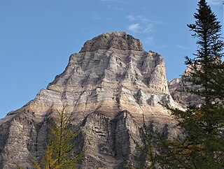
Mount Sir Donald is a 3,284-metre (10,774-foot) mountain summit located in the Rogers Pass area of Glacier National Park in the Selkirk Mountains of British Columbia, Canada. Its good rock quality and classic Matterhorn shape make it popular for alpine rock climbers, and the Northwest Arete route is included in the popular book Fifty Classic Climbs of North America.

Uto Peak is a mountain immediately north of Mount Sir Donald in the Selkirk Mountains of British Columbia, Canada. It was first climbed in 1890 by Emil Huber and Carl Sulzer.

Henry Fox was an English businessman, sportsman, and adventurer. He played cricket and rugby for his county, and began climbing mountains in the mid-1880s. He was part of the Fox family of Wellington, Somerset, and was a partner in the family business, Fox Brothers, a prominent textile manufacturer.

Mount Dawson, elevation 3,377 metres (11,079 ft), is a massif in the Selkirk Mountains of British Columbia, Canada, located in Glacier National Park to the southeast of Rogers Pass. It is a double summit, the highest of which is Hasler Peak, the second peak being Feuz Peak, with Hasler Peak's elevation making it the highest summit in Glacier National Park and the second highest in the Selkirks. Mount Dawson is ranked as the 58th highest mountain in British Columbia. The Dawson Glacier is located on its eastern flank.

Mount Tupper 2,804 m (9,199 ft) is a mountain about 37 kilometres (23 mi) west of Golden, British Columbia, Canada and three kilometres east of Rogers Pass in Glacier National Park. Part of the Selkirk Mountains, it was formerly named Hermit Mountain until renamed (1887) in honour of Sir Charles Tupper when he was minister of Railways and Canals in Sir John A. Macdonald's cabinet during the siting and construction of the CPR line through the Selkirk Mountains, and later Prime Minister.
Mount Huber is a 3,348-metre (10,984-foot) summit located two kilometres east of Lake O'Hara in the Bow Range of Yoho National Park, in the Canadian Rockies of British Columbia, Canada. The nearest higher neighbor is Mount Victoria, 1.0 km (0.62 mi) to the north-northeast on the Continental Divide. Mount Huber is a secondary summit of Mount Victoria.

Eagle Peak, is a 2,846-metre (9,337-foot) mountain summit located in Glacier National Park in the Selkirk Mountains in British Columbia, Canada. Its nearest higher peak is Uto Peak, 1.0 km (0.62 mi) to the east. Mount Sir Donald is 2.0 km (1.2 mi) to the southeast, and Mount Macdonald 4.0 km (2.5 mi) to the north. The Avalanche Glacier is situated on the northeast side of the peak. The peak is visible from eastbound Highway 1, the Trans-Canada Highway approaching Rogers Pass.

Avalanche Mountain, is a 2,861-metre (9,386-foot) mountain summit located in Glacier National Park in the Selkirk Mountains in British Columbia, Canada. Its nearest higher peak is Mount Macdonald, 2.2 km (1.4 mi) to the north. Mount Sir Donald is 3.83 km (2.38 mi) to the southeast, and Eagle Peak is 1.46 km (0.91 mi) to the south-southeast. The Avalanche Glacier is situated on the east side of the peak, and the Connaught Tunnel lies partially beneath Avalanche Mountain. The peak is visible from eastbound Highway 1, the Trans-Canada Highway approaching Rogers Pass. During winter and spring of each year the western slope, named Avalanche Crest, generates avalanches which can threaten the highway.

Mount Bonney, is a 3,100-metre (10,200-foot) mountain summit located in Glacier National Park in the Selkirk Mountains of British Columbia, Canada. Mount Bonney is surrounded by ice including the Bonney Glacier, Clarke Glacier, Swanzy Glacier, and Bonney Névé. Its nearest higher peak is Mount Sir Donald, 10.0 km (6.2 mi) to the northeast. Mount Bonney is visible from Highway 1, the Trans-Canada Highway at Rogers Pass.
Mount Swanzy is a 2,891-metre (9,485-foot) mountain summit located in Glacier National Park in the Selkirk Mountains of British Columbia, Canada. Mount Swanzy is surrounded by ice including the Bonney Glacier, Clarke Glacier, and Swanzy Glacier. Its nearest higher peak is Mount Bonney, 1.0 km (0.62 mi) to the west.

Mount Prestley is a 2,732-metre (8,963-foot) triple-summit mountain located in the Valhalla Ranges of the Selkirk Mountains in British Columbia, Canada. Mount Prestley is the eighth-highest point in the Valhalla Ranges, with the highest being Gladsheim Peak, 4.6 km (2.9 mi) to the east-northeast. Its nearest higher peak is Midgard Peak, 1.8 km (1.1 mi) to the east. It is situated on the southern border of Valhalla Provincial Park, and 16 km (9.9 mi) west of Slocan and Slocan Lake. The mountain's name was officially adopted January 24, 1962, by the Geographical Names Board of Canada. It honors Canadian Army Private Michael Thomas Patrick Prestley, from Nelson, BC. He was serving with The Black Watch of Canada when he was killed in World War II action July 22, 1944, at age 21.

Mount Macoun is a 3,030-metre (9,940-foot) mountain summit located in Glacier National Park of British Columbia, Canada. It is part of the Selkirk Mountains range. The mountain is a remote 61 km (38 mi) east of Revelstoke, and 32 km (20 mi) southwest of Golden. Its nearest higher peak is Mount Fox, 3.7 km (2.3 mi) to the southwest, and Mount Topham rises 4.4 km (2.7 mi) to the south. The expansive Illecillewaet Névé lies to the northwest, and two small unnamed glaciers lie at the bottom of the steep east face. Precipitation runoff from the mountain drains into the Beaver River.
Mount Selwyn, is a 3,335-metre (10,942-foot) mountain summit located in Glacier National Park of British Columbia, Canada. It is part of the Selkirk Mountains range. The mountain is situated 60 km (37 mi) east-northeast of Revelstoke, and 35 km (22 mi) southwest of Golden. Its nearest higher peak is Mount Dawson, 1 km (0.62 mi) to the west. Originally named Deville in 1888 by mountaineer Rev. William S. Green, Mount Selwyn was renamed to honor Alfred Richard Cecil Selwyn (1824-1902), director of the Geological Survey of Canada, and President of the Royal Society of Canada. The mountain's name was officially adopted September 8, 1932, by the Geographical Names Board of Canada. The first ascent of the mountain was made in 1890 by Harold E. Forster, Harold Ward Topham, Harry Sinclair, and Samuel Yves.

Mount Afton is a 2,553-metre (8,376-foot) mountain summit located in Glacier National Park in the Selkirk Mountains of British Columbia, Canada. It is situated near the north end of Asulkan Ridge, 8 km (5.0 mi) south of Rogers Pass, 56 km (35 mi) northeast of Revelstoke, and 40 km (25 mi) west of Golden.

Mount Green is a 2,692-metre (8,832-foot) mountain summit located in Glacier National Park, in the Selkirk Mountains of British Columbia, Canada. It is situated 4 km (2.5 mi) north-northwest of Mount Bonney, 10 km (6.2 mi) southwest of Rogers Pass, 52 km (32 mi) northeast of Revelstoke, and 44 km (27 mi) west of Golden. The mountain was named by Arthur Oliver Wheeler for Rev. William Spotswood Green (1847–1919), who explored, mapped, named, climbed, and wrote about the Selkirk Mountains. His book "Among the Selkirk Glaciers", published in 1890, introduced the world to the Selkirk Mountains. He is credited with recommending the location for a small chalet to the Canadian Pacific Railway that would grow to become the Chateau Lake Louise hotel, as well as making the first ascent of Mount Bonney. The mountain's name was officially adopted September 8, 1932, when approved by the Geographical Names Board of Canada. The first ascent of the mountain was made August 25, 1910, by Alexander A. McCoubrey and Ernest Feuz who climbed the south ridge and descended the north ridge.

Hermit Mountain is a 3,050-metre (10,010-foot) mountain summit located in Glacier National Park, in the Hermit Range of the Selkirk Mountains in British Columbia, Canada. Hermit Mountain is situated 64 km (40 mi) northeast of Revelstoke, and 39 km (24 mi) west of Golden. It is also set 2.7 km (1.7 mi) north-northwest of Mount Tupper, and 6 km (3.7 mi) north of Rogers Pass, from which it can be seen from the Trans-Canada Highway. The nearest higher peak is Swiss Peak on Mount Rogers, 1 km (0.62 mi) to the west. The first ascent of the mountain was made August 4, 1904, by Alex M. Gordon, Samuel Harper Gray, James C. Herdman, Edward Feuz, and Edward Feuz Jr. via the Southeast Couloir. The mountain's name was adopted in 1904, then re-approved September 8, 1932, by the Geographical Names Board of Canada.

Mount Cooper is a prominent 3,094-metre (10,151 ft) glaciated mountain summit located in the Selkirk Mountains of southeast British Columbia, Canada. It is situated 36 km (22 mi) northwest of Kaslo, within Goat Range Provincial Park. Mt. Cooper is the highest peak in the Goat Range and Slocan Ranges, which are subsets of the Selkirks. The nearest higher peak is Truce Mountain, 33 km (21 mi) to the east-northeast. The first ascent of Mount Cooper was made August 10, 1962, by William Boulton, Terry Beck, Richard Hahn, Lorna Ream, Jack Steele, Edward Bouttin and Gary Johnson via the Spokane Glacier. This climbing party was from the Spokane Mountaineers organization. The mountain was named in association with Cooper Creek, which in turn was named after an 1880s Kaslo prospector and trapper. The mountain's name was officially adopted June 9, 1960, when approved by the Geographical Names Board of Canada. Prior to 1960 it was called Cooper Mountain.
Mount Butters is a 3,141-metre (10,305-foot) mountain summit in British Columbia, Canada.

Purity Mountain is a 3,149-metre (10,331-foot) summit in British Columbia, Canada.

Mount Donkin is a 2,940-metre (9,646-foot) summit in British Columbia, Canada.


