Related Research Articles

Washington Parish is a parish located in the interior southeast corner of the U.S. state of Louisiana, one of the Florida Parishes. As of the 2020 census, the population was 45,463. Its parish seat is Franklinton. Its largest city is Bogalusa. The parish was founded in 1819.

Sorrento is a town in Ascension Parish, Louisiana, United States. The population was 1,514 in 2020. It is part of the Baton Rouge metropolitan statistical area.
Elmwood is a census-designated place (CDP) in Jefferson Parish, Louisiana, United States, within the New Orleans–Metairie–Kenner metropolitan statistical area. The population was 4,635 at the 2010 census, and 5,649 in 2020. Elmwood was part of neighboring Jefferson's census area from 1960 to 1990. The ZIP Code serving Elmwood is 70123.

Golden Meadow French: Canal Yankee is a town along Bayou Lafourche in Lafourche Parish, Louisiana, United States. The population was 1,761 in 2020. It is part of the Houma–Bayou Cane–Thibodaux metropolitan statistical area. Its main source of revenue is the oil and gas industry. The fishing and seafood industries also have strong economic impacts, with charter fishing, restaurants, and lodging actively serving patrons. The town was once known as a speed trap, but it has since been bypassed by Hwy 3235 and city traffic has been reduced to mostly locals; however, the speed limit is reduced to 50 mph on Hwy 3235 and said highway is still patrolled heavily. As in other places in Louisiana, there is a noticeable presence of Cajun culture, music, and cuisine.

Larose is an unincorporated community and census-designated place (CDP) in Lafourche Parish, Louisiana, United States. The population was 6,763 in 2020. It is part of the Houma–Bayou Cane–Thibodaux metropolitan statistical area.
Norco is a census-designated place (CDP) in St. Charles Parish, Louisiana, United States. The population was 2,984 at the 2020 census. The community is home to a major Shell/Valero manufacturing complex. The CDP's name is derived from the New Orleans Refining Company.
Saint Rose is a census-designated place (CDP) in St. Charles Parish, Louisiana, United States. St. Rose is on the east bank of the Mississippi River, two miles (3 km) north of the Jefferson Parish border and is part of the Greater New Orleans metropolitan area. The population was 6,540 in the 2000 census, and 7,504 in 2020.
Independence, originally known as Uncle Sam, is a town in Tangipahoa Parish, Louisiana, United States. The population was 1,665 at the 2010 census. It is part of the Hammond Micropolitan Statistical Area.

Roseland is a town in Tangipahoa Parish, Louisiana, United States. The population was 1,123 at the 2010 census. It is the birthplace of Cajun chef and storyteller Justin Wilson.
Gray is a census-designated place (CDP) in Terrebonne Parish, Louisiana. The population was 5,518 in 2020. It is part of the Houma–Bayou Cane–Thibodaux metropolitan statistical area.
Montegut is a census-designated place (CDP) in Terrebonne Parish, Louisiana, United States. The population was 1,540 at the 2010 census. It is part of the Houma–Bayou Cane–Thibodaux metropolitan statistical area. Montegut was the primary filming location for the 2012 film Beasts of the Southern Wild.

Caddo Parish is a parish located in the northwestern corner of the U.S. state of Louisiana. According to the 2020 U.S. census, the parish had a population of 237,848. The parish seat is Shreveport, which developed along the Red River.
Mount Hermon High School is located in Mount Hermon, Louisiana, United States. The high school is currently housed out of the same facility as the Mount Hermon elementary and junior high schools. The first Mount Hermon School, constructed in the mid-19th century, held classes in a log cabin near the Mount Hermon Cemetery. A new building was constructed for the school in 1885, and that structure is currently located in the Mile Branch Settlement at the Washington Parish Fairgrounds.
Watson is an unincorporated community and census-designated place (CDP) in Livingston Parish, Louisiana, United States. The community is in the Baton Rouge Metropolitan Statistical Area.
Holden is an unincorporated community located on U.S. Highway 190 between Albany and Livingston in Livingston Parish, Louisiana, United States. Holden is in a section of land awarded to Micajah "Cage" Spiller by a Spanish land grant. LA Hwy 441 which runs through Holden in a northwest–southeast direction is the road that connected Springfield with Baton Rouge to the west and points in Mississippi to the east. In 1907, the east–west line of the Baton Rouge, Hammond & Eastern Railroad was constructed.

Cloutierville is an unincorporated community in Natchitoches Parish, Louisiana, United States. It lies approximately 20 miles (32 km) south of the city of Natchitoches on the Cane River. The community is part of the Natchitoches Micropolitan Statistical Area, off exit 119 of Interstate 49.
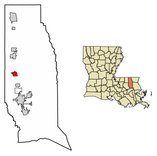
Pine is an unincorporated community located in Washington Parish, Louisiana, United States. It is home to Pine Junior/Senior High School, a K-12 school with approximately 600 students. Pine utilizes the zip code from the neighboring town of Franklinton. Pine is accessed be either LA highway 62 (N-S) or LA highway 436 (E-W). Pine has several small, family owned businesses. In September 2010 the first, and only retail chain store opened. The businesses surround the 62-436 intersection and flow north on Hwy 62 toward the "New" High School.
Maurepas is an unincorporated community in the south/southwestern area of Livingston Parish, Louisiana, United States. Louisiana Highway 22 passes through the community and Whitehall lies two miles to the east. Lake Maurepas is six miles to the east and the Amite River lies approximately one half mile to the north. The ZIP Code for Maurepas is 70449.
Burnside is an unincorporated community in Ascension Parish, Louisiana, United States. It was founded by French and German settlers in 1726, early in the French colonial period. The ZIP Code for Burnside is 70738.
Brittany is an unincorporated community in Ascension Parish, Louisiana, in the United States.
References
- ↑ "Mount Hermon ZIP Code". zipdatamaps.com. 2022. Retrieved November 11, 2022.
Municipalities and communities of Washington Parish, Louisiana, United States | ||
|---|---|---|
| City | 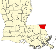 | |
| Town | ||
| Villages | ||
| CDP | ||
| Other communities | ||
30°57′37″N90°17′45″W / 30.96028°N 90.29583°W
| | This Louisiana state location article is a stub. You can help Wikipedia by expanding it. |