Mount Pleasant, Utah

Last updated

Mount Pleasant, Utah
Mount Pleasant Utah.jpg
Historic buildings on Mount Pleasant's Main Street
Sanpete County Utah incorporated and unincorporated areas Mount Pleasant highlighted.svg
Location in Sanpete County and the state of Utah.
USA Utah location map.svg
Red pog.svg
Mount Pleasant
Usa edcp location map.svg
Red pog.svg
Mount Pleasant
Coordinates: 39°32′35″N111°27′23″W / 39.54306°N 111.45639°W / 39.54306; -111.45639
Country Flag of the United States (23px).png  United States
State Flag of Utah.svg  Utah
County Sanpete
Incorporated1868 [1]
Founded byMadison Hambleton
Area
[2]
  Total2.93 sq mi (7.59 km2)
  Land2.93 sq mi (7.59 km2)
  Water0.00 sq mi (0.00 km2)
Elevation
[3]
5,925 ft (1,806 m)
Population
 (2020)
  Total3,655
  Estimate 
(2019) [4]
3,530
  Density1,204.78/sq mi (465.11/km2)
Time zone UTC-7 (Mountain (MST))
  Summer (DST) UTC-6 (MDT)
ZIP code
84647
Area code 435
FIPS code 49-53010 [5]
GNIS feature ID1430522 [3]
Website Mount Pleasant City Website

Mount Pleasant is a city in the U.S. state of Utah. Located in Sanpete County, Mt. Pleasant is known for being home to Wasatch Academy. [6] As of the 2010 census, the city's population was 3,260.

Contents

History

In the spring of 1852, Latter-Day Saint colonists from Manti led by Madison D. Hambleton established the Hambleton Settlement near the present site of Mt. Pleasant. [7] During the Wakara War, the settlers relocated to Spring Town (Spring City), and later to Manti for protection. Local Native Americans destroyed the old settlement by setting it on fire. A large colonizing party from Ephraim and Manti returned to the area in 1859, and a permanent site was laid out in its present location. [8]

Among the founding settlers were Latter-Day Saint converts from Scandinavia, the United Kingdom, and the eastern United States. By 1880, Mt. Pleasant was the county's largest city, with a population of 2,000. More than 72 percent of its married adults were foreign-born. This ethnic diversity had an important impact on village life during the nineteenth and early twentieth centuries. For decades, five languages were commonly spoken in the town. [9]

The settlement and development of Mt. Pleasant followed the typical pattern for Latter-Day Saint towns of the period. A square-shaped town site was surveyed, lots were drawn, and the land was distributed among the population. Under the direction of James Russell Ivie (1802–1866), a fort of adobe walls and log cabins was built. Pleasant Creek ran through the fort, and farming was done outside of its walls. Ivie was killed in the Ute Black Hawk War by Indians who had declined to participate in the settlement of the earlier Wakara War. Around that time, the town acquired its present name. In 1872 the final peace treaty with the Indians was signed in Bishop Seeley's house on Main Street, bringing an end to this conflict. By this time, many settlers had erected homesteads outside of the fort. The town site may be expansive, but the population density remains relatively low, owing to the original layout that permitted only four lots per block. [10]

Some of the first industries in Mt. Pleasant included tanning, shoe making, blacksmithing, basket making, and freighting. Eventual modernization brought such improvements as the Deseret Telegraph in 1869, the Pyramid Newspaper in 1890, and a telephone system in 1891.

Sawmills and flour mills were built, irrigation systems were dug, and a municipal government was created to oversee public laws and improvements. The city was incorporated in 1868, a year after the first cooperative store was founded. Upon the arrival of the Rio Grande Western Railway in 1890, both the local population and the city's prosperity increased dramatically. By 1900, Mt. Pleasant had grown to nearly 3,000 people, the largest size reached by any city in Sanpete County to that time, and the city had earned one of its nicknames, "Hub City".[ citation needed ]

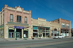
The town's increased wealth resulted in the replacement of small, wood-frame commercial buildings with more durable stone and brick structures, such as the Sanpete County Co-op built in 1888. Additionally, the pioneer period's simpler adobe and log buildings were replaced with more elaborate Victorian-style churches, schools, and residences.

By 1912, the first high school, North Sanpete High School, had been completed. 1912 also brought the Armory Hall, while the Elite Theater was constructed as a "fireproof" building in 1913. It burned down seven decades later.[ date missing ] In 1917, a Carnegie Library was built in a modern architectural style. The Marie Hotel was erected in 1920 and a large cheese factory was built in 1930, the same year that the bus service came to town. The completion of U.S. Highway 89 in 1936 softened the impact of the Great Depression. A city hall was built in 1939 and a hospital in 1945.

Geography

Panoramic view of Mt. Pleasant looking east along Highway 116 Mount pleasant evening.jpg
Panoramic view of Mt. Pleasant looking east along Highway 116

According to the United States Census Bureau, the city has a total area of 2.8 square miles (7.3 km2).

Climate

This climatic region is typified by large seasonal temperature differences, with warm, dry summers and cold (sometimes severely cold) winters. According to the Köppen Climate Classification system, Mount Pleasant has a warm summer continental climate, abbreviated "DFB" on climate maps. [11]

Demographics

Historical population
CensusPop.Note
1860 746
1870 1,34680.4%
1880 2,00448.9%
1890 2,25412.5%
1900 2,3725.2%
1910 2,280−3.9%
1920 2,4186.1%
1930 2,284−5.5%
1940 2,3824.3%
1950 2,030−14.8%
1960 1,572−22.6%
1970 1,516−3.6%
1980 2,04935.2%
1990 2,0922.1%
2000 2,70729.4%
2010 3,26020.4%
2020 3,65512.1%
U.S. Decennial Census [12]

As of the census [5] of 2000, there were 2,707 people, 884 households, and 655 families residing in the city. The population density was 958.8 people per square mile (370.6/km2). There were 975 housing units at an average density of 345.3 per square mile (133.5/km2). The racial makeup of the city was 96.45% White, 0.41% Native American, 0.48% Asian, 0.15% Pacific Islander, 1.18% from other races, and 1.33% from two or more races. Hispanic or Latino of any race were 2.66% of the population.

There were 884 households, out of which 40.7% had children under the age of 18 living with them, 62.0% were married couples living together, 7.6% had a female householder with no husband present, and 25.9% were non-families. 23.4% of all households were made up of individuals, and 13.9% had someone living alone who was 65 years of age or older. The average household size was 2.99 and the average family size was 3.56.

In the city, the population was spread out, with 36.5% under the age of 18, 8.5% from 18 to 24, 22.7% from 25 to 44, 18.6% from 45 to 64, and 13.8% who were 65 years of age or older. The median age was 30 years. For every 100 females, there were 96.6 males. For every 100 females aged 18 and over, there were 97.0 males.

The median income for a household in the city was $33,603, and the median income for a family was $40,300. Males had a median income of $32,697 versus $17,279 for females. The per capita income for the city was $13,630. About 7.0% of families and 9.2% of the population were below the poverty line, including 9.3% of those under age 18 and 9.9% of those aged 65 or over.

Arts and culture

Annual cultural events

Hub City Days and the Fourth of July Celebration include a parade down state street featuring local businesses and residents. Events include a breakfast at the city park, a carnival at the city park, a rodeo featuring local cowboys, and fireworks following the rodeo.[ citation needed ] [13]

Mt. Pleasant Pioneer Day is held the last Saturday in March.[ citation needed ]

Education

Mount Pleasant is within the North Sanpete School District and has one elementary school and North Sanpete High School, the only high school in the district. [14] The district's middle school is located in Moroni. [15] Mount Pleasant is also home to Wasatch Academy, a private boarding school established in 1875. [16]

Notable people

Related Research Articles

<span class="mw-page-title-main">Juab County, Utah</span> County in Utah, United States

Juab County is a county in western Utah, United States. As of the 2020 United States Census, the population was 11,786. Its county seat and largest city is Nephi.

<span class="mw-page-title-main">Sanpete County, Utah</span> County in Utah, United States

Sanpete County is a county in the U.S. state of Utah. As of the 2020 United States Census, the population was 28,437. Its county seat is Manti, and its largest city is Ephraim. The county was created in 1850.

<span class="mw-page-title-main">Wasatch County, Utah</span> County in Utah, United States

Wasatch County is a county in the U.S. state of Utah. As of the 2020 United States Census, the population was 34,788. Its county seat and largest city is Heber City. The county was named for a Ute word meaning "mountain pass" or "low place in the high mountains".

<span class="mw-page-title-main">Utah County, Utah</span> County in Utah, United States

Utah County is the second-most populous county in the U.S. state of Utah. The county seat and largest city is Provo, which is the state's fourth-largest city, and the largest outside of Salt Lake County. As of the 2020 United States Census, the population was 665,665.

<span class="mw-page-title-main">Mount Pleasant, Michigan</span> City in Michigan, United States

Mount Pleasant is a city in the U.S. state of Michigan. The city is the county seat of Isabella County, which is part of Central Michigan. The population of Mount Pleasant was 21,688 as of the 2020 census. The city is surrounded by Union Charter Township, but is politically independent.

<span class="mw-page-title-main">Mount Pleasant, Tennessee</span> City in Tennessee, United States

Mount Pleasant is a city in Maury County, Tennessee, United States. Mount Pleasant was the birthplace of 19th-century writer and humorist Samuel R. Watkins and formerly titled "The Phosphate Capital of the World." The population was 4,561 at the 2010 census, and 4,784 in 2020.

<span class="mw-page-title-main">Price, Utah</span> City in Utah, United States

Price is a city in the U.S. state of Utah and the county seat of Carbon County. The city is home to Utah State University Eastern, as well as the USU Eastern Prehistoric Museum. Price is located within short distances of both Nine Mile Canyon and the Manti-La Sal National Forest.

<span class="mw-page-title-main">Woods Cross, Utah</span> City in Utah, United States

Woods Cross is a city in Davis County, Utah, United States. It is part of the Ogden–Clearfield, Utah Metropolitan Statistical Area. The population was 9,761 as of the 2010 census, with an estimated population in 2019 of 11,431.

<span class="mw-page-title-main">Huntington, Utah</span> City in Utah, United States

Huntington is a city in northwestern Emery County, Utah, United States. The population was 2,129 at the 2010 census. It is the largest town in Emery County.

<span class="mw-page-title-main">Centerfield, Utah</span> City in Utah, United States

Centerfield is a city in southwestern Sanpete County, Utah, United States. The population was 1,341 at the 2020 census. Although Centerfield was a town in 2000, it has since been classified as a fifth-class city by state law. The community was so named because of its location in the center of a wide valley.

<span class="mw-page-title-main">Ephraim, Utah</span> City in Utah, United States

Ephraim is a city in Sanpete County, Utah, United States. The population was 5,611 at the 2020 census, making it the largest city in Sanpete County. It is the location of Snow College and is located along U.S. Route 89.

<span class="mw-page-title-main">Fairview, Utah</span> City in Utah, United States

Fairview is a city in northern Sanpete County, Utah, United States. The population was 1,203 at the 2020 census.

<span class="mw-page-title-main">Gunnison, Utah</span> City in Utah, United States

Gunnison is a city in the Sevier Valley in southwestern Sanpete County, Utah, United States. The population was 3,509 at the 2020 census. The city was named in honor of John W. Gunnison, a United States Army officer who surveyed for the transcontinental railroad in 1853.

<span class="mw-page-title-main">Manti, Utah</span> City in Utah, United States

Manti is a city in and the county seat of Sanpete County, Utah, United States. The population was 3,276 at the 2010 United States Census.

<span class="mw-page-title-main">Moroni, Utah</span> City in Utah, United States

Moroni is a city in Sanpete County, Utah, United States. The population was 1,423 at the 2010 census.

<span class="mw-page-title-main">Spring City, Utah</span> City in Utah, United States

Spring City is a city in Sanpete County, Utah, United States. The population was 988 at the 2010 census.

<span class="mw-page-title-main">Alpine, Utah</span> City in Utah, United States

Alpine is a city on the northeastern edge of Utah County, Utah, United States. The population was 10,251 at the time of the 2020 census. Alpine has been one of the many quickly-growing cities of Utah since the 1970s, especially in the 1990s. This city is thirty-two miles southeast of Salt Lake City. It is located on the slopes of the Wasatch Range north of Highland and American Fork. The west side of the city runs above the Wasatch Fault.

<span class="mw-page-title-main">Pleasant Grove, Utah</span> City in Utah, United States

Pleasant Grove, originally named Battle Creek, is a city in Utah County, Utah, United States, known as "Utah's City of Trees". It is part of the Provo–Orem Metropolitan Statistical Area. The population was 37,726 at the 2020 Census.

<span class="mw-page-title-main">Heber City, Utah</span> City in Utah, United States

Heber City is a city and county seat of Wasatch County, Utah. The population was 16,856 as of the 2020 United States census. The city is located 43 miles southeast of Salt Lake City.

<span class="mw-page-title-main">Midway, Utah</span> City in Utah, United States

Midway is a city in northwestern Wasatch County, Utah, United States. It is located in the Heber Valley, approximately 3 miles (4.8 km) west of Heber City and 28 miles (45 km) southeast of Salt Lake City, on the opposite side of the Wasatch Mountains. The population was 6,003 at the 2020 census.

References

  1. "Mount Pleasant, Utah". City-Data.com. Retrieved September 19, 2012.
  2. "2019 U.S. Gazetteer Files". United States Census Bureau. Retrieved August 7, 2020.
  3. 1 2 U.S. Geological Survey Geographic Names Information System: Mount Pleasant, Utah
  4. "Population and Housing Unit Estimates". United States Census Bureau. May 24, 2020. Retrieved May 27, 2020.
  5. 1 2 "U.S. Census website". United States Census Bureau . Retrieved January 31, 2008.
  6. "Contact Us". Wasatch Academy | America's Boarding School. Retrieved September 18, 2023.
  7. "Mount Pleasant City, Utah". Sanpete County. Retrieved September 18, 2023.
  8. "Mount Pleasant, Utah | Advisory Council on Historic Preservation". www.achp.gov. Retrieved October 14, 2023.
  9. "Utah History Encyclopedia". www.uen.org. Retrieved May 8, 2024.
  10. root (September 27, 2023). "UAE Desert Adventures | Dubai Adventure Tours". UAE Desert Adventures. Retrieved October 31, 2023.
  11. Climate Summary for Mount Pleasant, Utah
  12. "Census of Population and Housing". Census.gov. Retrieved June 4, 2015.
  13. "Mt. Pleasant Hub City Days". 2022.
  14. "NORTH SANPETE SCHOOL DISTRICT".
  15. "North Sanpete Middle School".
  16. "America's boarding school since 1875".
  17. "JORDAN, Leonard Beck (Len), (1899 - 1983)". Biographical Directory of the United States Congress. Retrieved September 16, 2012.

Further reading