
Dungog is a country town on the Williams River in the Hunter Region of New South Wales, Australia. Located in the middle of dairy and timber country, it is the centre of the Dungog Shire local government area and at the 2016 census it had a population of 2,025 people. The area includes the Fosterton Loop, 22 kilometres (14 mi) of road, used in the annual Pedalfest. A small portion of Dungog lies in the Mid-Coast Council LGA.

Paterson is a small township in the lower Hunter Region of New South Wales, Australia. Located within Dungog Shire and City of Maitland, it is situated on the Paterson River. It is in the middle of what was once dairy, timber and citrus country and is now more significantly a feeder town for the nearby mining industry in the Upper Hunter and the city of Newcastle. It was named after one of the first known Europeans in the area was Colonel William Paterson in 1801 surveyed the area beside the river.

Paterson River, a perennial river that is part of the Hunter River catchment, is located in the Hunter and Mid North Coast regions of New South Wales, Australia.

Port Stephens Council is a local government area in the Hunter Region of New South Wales, Australia. The area is just north of Newcastle and is adjacent to the Pacific Highway which runs through Raymond Terrace, the largest town and Council seat. The area is named after Port Stephens, which is the major geographical feature of the area. It extends generally from the Hunter River in the south, to near Clarence Town in the north, and from the Tasman Sea in the east, to just south of Paterson in the west. The mayor of Port Stephens Council is Ryan Palmer. Palmer was caught in a major scandal in 2022 following the purchase of an $86,000 Ford Ranger for mayoral and personal use. Port Stephens is about two and a half hours north of Sydney.
East Gresford is a village in the Hunter Region of New South Wales, Australia in Dungog Shire. The village is located 192 kilometres (119 mi) north of Sydney and the nearest major centres are Singleton some 42 kilometres (26 mi) southwest and Maitland to the south. In the 2006 census, it had a population of 289.
Gresford is a locality in the Dungog Shire, New South Wales, Australia.

Wee Jasper is a hamlet in the Yass Valley Shire in New South Wales, Australia, about 90 km north-west of Canberra and 60 km south-west of Yass. It is in the Goodradigbee valley at the western foot of the Brindabella Ranges, near Burrinjuck Dam. At the 2021 census, Wee Jasper and the surrounding area had a population of 127.

Gloucester Shire was a local government area in the Mid North Coast and Upper Hunter regions of New South Wales, Australia. The Shire was situated adjacent to the Bucketts Way and the North Coast railway line.

Dungog Shire is a local government area in the Hunter region of New South Wales, Australia. The Shire is situated adjacent to the Barrington Tops and consists predominantly of very rugged to hilly country which becomes less rugged from north to south.
Glen Oak is a small community in the Hunter Region of New South Wales, Australia, shared between the Port Stephens and Dungog local government areas (LGA). Approximately two thirds of the suburb's 45.1 square kilometres (17.4 sq mi) is located within the Port Stephens LGA while the remaining third, which is sparsely populated, is located in Dungog Shire.

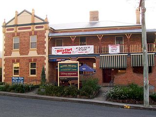
Vacy is a locality of the Dungog Shire local government area in the Hunter Region of New South Wales, Australia. Situated between Gresford and Paterson, it includes the village of Vacy, which was founded in the 1820s as a private town by John Cory, the owner of a large land grant. Vacy began to prosper in the 1850s and was a busy town by the 1870s. It remained a private town until it was sold in 1927 by the Cory family. The village is located at the junction of the Paterson and Allyn rivers. At the 2011 census, Vacy had a population of 547.
Martins Creek is a small country town located between Dungog and Maitland in the Hunter Region of Australia.
Gringai otherwise known as Guringay, is the name for one of the Australian Aboriginal people who were recorded as inhabiting an area of the Hunter Valley in eastern New South Wales, north of Sydney. They were united by a common language, strong ties of kinship and survived as skilled hunter–fisher–gatherers in family groups as a clan of the Worimi people.

Allyn River, a perennial stream of the Hunter River catchment, is located in the Hunter region of New South Wales, Australia.
Glen Martin is a scattered rural community located within the Hunter Region of New South Wales, Australia. It is part of the Dungog local government area.

Hoskinstown is a locality in Queanbeyan-Palerang Regional Council, New South Wales, Australia. The locality, and what remains of the cluster of settlement of the same name, is 38 km southeast of Canberra the Capital city of Australia, and 299 km southwest of Sydney. At the 2021 census, it had a population of 191.

Colinton is a locality in the Snowy Monaro Region, New South Wales, Australia. At the 2016 census, it had a population of 127. There was once a village and railway station of the same name.

Clarence Town Courthouse is a heritage-listed former courthouse and now museum at 49 Grey Street, Clarence Town, Dungog Shire, New South Wales, Australia. It was built from 1868 to 1869. It was added to the New South Wales State Heritage Register on 2 April 1999.
Wallarobba Shire was a local government area in the Hunter region of New South Wales, Australia.
Numeralla, is a village in Snowy Monaro Region of New South Wales, Australia. The name is also applied to the surrounding area, for postal and statistical purposes. In 2016, the population of the village and its surrounding area was 258. The village was known as Umaralla until 1972.
