Mount Wilbur (Alaska)

Last updated
Mount Wilbur
Highest point
Elevation 10,821 ft (3,298 m) [1]
Prominence 3,963 ft (1,208 m) [1]
Coordinates 58°44′24″N137°19′07″W / 58.74000°N 137.31861°W / 58.74000; -137.31861
Geography
Location Glacier Bay National Park and Preserve, Alaska, U.S.
Parent range Fairweather Range, Saint Elias Mountains
Topo map USGS Mount Fairweather C-4 Quadrangle
Climbing
First ascent 1975 by D. Jones, C. Gerhardt, C. McKibben
Easiest route snow/ice climb

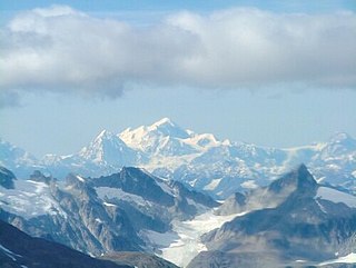
Mount Wilbur is a high peak of the Fairweather Range, the southernmost part of the Saint Elias Mountains. It lies approximately 14 miles (22 km) southeast of Mount Fairweather and 8 miles (13 km) northwest of Mount Crillon. It is included in Glacier Bay National Park. The peak is the higher of a pair of peaks, Mounts Wilbur and Orville, named after the Wright Brothers.

Mount Fairweather mountain on BC-Alaska border

Mount Fairweather, is the highest mountain in the Canadian province of British Columbia, with an elevation of 4,671 metres. It is located 20 km (12 mi) east of the Pacific Ocean on the border of Alaska, United States and western British Columbia, Canada. Most of the mountain lies within Glacier Bay National Park and Preserve in the City and Borough of Yakutat, Alaska (USA), though the summit borders Tatshenshini-Alsek Provincial Park, British Columbia (Canada). It is also designated as Boundary Peak 164 or as US/Canada Boundary Point #164.

Saint Elias Mountains

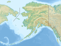
The Saint Elias Mountains are a subgroup of the Pacific Coast Ranges, located in southeastern Alaska in the United States, Southwestern Yukon and the very far northwestern part of British Columbia in Canada. The range spans Wrangell-St. Elias National Park and Preserve in the United States and Kluane National Park and Reserve in Canada and includes all of Glacier Bay National Park in Alaska. In Alaska, the range includes parts of the city/borough of Yakutat and the Hoonah-Angoon and Valdez-Cordova census areas.

Mount Crillon mountain in United States of America

Mount Crillon is a high peak of the Fairweather Range, the southernmost part of the Saint Elias Mountains. It lies southeast of Mount Fairweather, in the promontory between the Gulf of Alaska and Glacier Bay. It is included in Glacier Bay National Park. The peak was named after Felix-Francois-Dorothee de Bretton, Comte de Crillon, by his friend, the French explorer Jean Francois de Galaup de la Perouse.

Though not a particularly high peak in absolute terms, Mount Wilbur does stand quite high above local terrain, due to its proximity to the ocean: the summit is only 7.5 miles from tidewater at the head of Lituya Bay to the southwest.

Lituya Bay

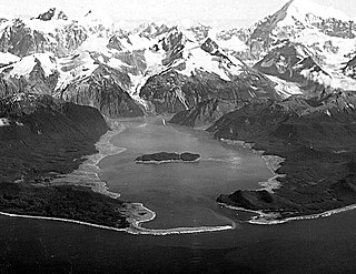
Lituya Bay is a fjord located on the coast of the Southeast part of the U.S. state of Alaska. It is 14.5 km (9.0 mi) long and 3.2 km (2.0 mi) wide at its widest point. The bay was noted in 1786 by Jean-François de La Pérouse, who named it Port des Français. Twenty-one of his men perished in the tidal current in the bay.

Related Research Articles

Fourteener Wikimedia list article

In the mountaineering parlance of the Western United States, a fourteener is a mountain peak with an elevation of at least 14,000 feet. There are 96 fourteeners in the United States, all west of the Mississippi River. Colorado has the most (53) of any single state; Alaska is in second place with 29. Many peak baggers try to climb all fourteeners in the contiguous United States, one particular state, or another region.

Mount Salisbury is a peak in the Fairweather Range of Alaska, 6 miles (10 km) southeast of Mount Fairweather. Its east slopes feed one of the northern branches of the Johns Hopkins Glacier, which flows into Glacier Bay. On its western side is a large cirque, shared with Mount Fairweather, Mount Quincy Adams, and Lituya Mountain, which heads the Fairweather Glacier; this flows almost to the Pacific coast at Cape Fairweather.

Lituya Mountain mountain in United States of America

Lituya Mountain is a peak in the Fairweather Range of Alaska, United States, south of Mount Fairweather. Its eastern slopes feed a branch of the Johns Hopkins Glacier, which flows into Glacier Bay. On its western side is a large cirque, shared with Mount Fairweather, Mount Quincy Adams, and Mount Salisbury, which heads the Fairweather Glacier; this flows almost to the Pacific coast at Cape Fairweather. The Lituya Glacier flows from the south side of the mountain into Lituya Bay on the Pacific coast.

Fairweather Range

The Fairweather Range is the unofficial name for a mountain range located in the U.S. state of Alaska and the Canadian province of British Columbia. It is the southernmost range of the Saint Elias Mountains. The northernmost section of the range is situated in Tatshenshini-Alsek Provincial Park while the southernmost section resides in Glacier Bay National Park, in the Hoonah-Angoon Census Area. In between it goes through the southeastern corner of Yakutat Borough. Peaks of this range include Mount Fairweather, the highest point in British Columbia and Mount Quincy Adams 4,150 m (13,615 ft).

Mount Cook (Saint Elias Mountains) mountain

Mount Cook is a high peak on the Yukon Territory-Alaska border, in the Saint Elias Mountains of North America. It is approximately 15 miles southwest of Mount Vancouver and 35 miles east-southeast of Mount Saint Elias. It forms one of the corners of the jagged border, which is defined to run in straight lines between the major peaks. The same border also separates Kluane National Park in the Yukon Territory from Wrangell-St. Elias National Park and Preserve in Alaska.

Mountain peaks of Canada Wikimedia list article

This article comprises three sortable tables of major mountain peaks of Canada.

Mount Ulysses mountain in Canada

Mount Ulysses, is the highest mountain in the Muskwa Ranges of the Northern Canadian Rockies in British Columbia. It and neighbouring peaks are part of a group of names drawing on the epic poem The Odyssey, in which here Ulysses wanders for 10 years before being able to return home to Ithaca.

Mount Orville mountain

Mount Orville is a high peak of the Fairweather Range, the southernmost part of the Saint Elias Mountains. It is included in Glacier Bay National Park. The peak is the lower of a pair of peaks, Mounts Wilbur and Orville, named after the Wright Brothers.

References

  1. 1 2 "Mount Wilbur". Bivouac.com. Retrieved 14 Dec 2013.