Related Research Articles

Falmouth is a census-designated place (CDP) in Stafford County, Virginia, United States. Situated on the north bank of the Rappahannock River at the falls, the community is north of and opposite the city of Fredericksburg. Recognized by the U.S. Census Bureau as a census-designated place (CDP), Falmouth's population was 4,274 as of the 2010 census.

The Roanoke River is a river in southern Virginia and northeastern North Carolina in the United States, 410 miles (660 km) long. A major river of the southeastern United States, it drains a largely rural area of the coastal plain from the eastern edge of the Appalachian Mountains southeast across the Piedmont to Albemarle Sound. An important river throughout the history of the United States, it was the site of early settlement in the Virginia Colony and the Carolina Colony. An 81-mile (130 km) section of its lower course in Virginia between the Leesville Lake and Kerr Lake is known as the Staunton River, pronounced, as is the Shenandoah Valley city of that name. It is impounded along much of its middle course to form a chain of reservoirs.

Burke Lake is a 218 acres (88 ha) freshwater reservoir in Fairfax Station, Fairfax County, Virginia, United States. It is contained within Burke Lake Park, a Fairfax County public park owned by the Fairfax County Park Authority (FCPA). Burke Lake is formed by a dam on South Run, a tributary stream of the Potomac River.
Gardy's Millpond is a 75 acres (30.35 ha) reservoir located in a tranquil setting along the Westmoreland and Northumberland county line in Northeast Virginia.
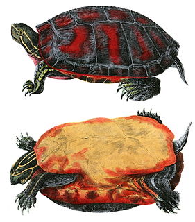
The northern red-bellied turtle or American red-bellied turtle is a species of turtle in the Pseudemys (cooter) genus of the family Emydidae.
Lake Habeeb is a reservoir of 243 acres (0.98 km2) and is located in Allegany County, Maryland, United States. The lake is fed by Rocky Gap Run, and nestled against the east side of the southern tip of Evitts Mountain. The dam was built by the Army Corps of Engineers in 1970 and Rocky Gap State Park formally opened on July 17, 1974, it attains a maximum depth of 74 feet (23 m) near its earthen dam. It offers three public beach areas along Habeeb's 9.4-mile (15.1 km) shoreline, as well as an arguably superb fishery.

Briery Creek Wildlife Management Area is a 3,164-acre (12.80 km2) Wildlife Management Area in Prince Edward County, Virginia. With terrain typical of Virginia's south-central Piedmont, it encompasses the 845-acre (3.42 km2) Briery Creek Lake, a reservoir formed by the damming of Briery Creek and Little Briery Creek. Much of the area was historically used for tobacco farming, and more recently, timber production; today the land contains a mixture of hardwoods and loblolly pine.

Chester F. Phelps Wildlife Management Area is a 4,539-acre (18.37 km2) Wildlife Management Area located in Fauquier and Culpeper counties, Virginia. It contains over 1,000 acres (4 km2) of open land previously used for agriculture; additional open areas may be found within the forests on the property. Most of the terrain is rolling, low, and shallow; the steepest land can be seen near the Rappahannock River, which forms a large part of the property's western border. A number of small streams cross the land, and a three-acre (12,000 m2) pond is located near its center. The forests on the property contain both pine and hardwood.
Clinch Mountain Wildlife Management Area is a 25,477-acre (103.10 km2) Wildlife Management Area (WMA) in Virginia. It is the second-largest WMA in the Commonwealth, covering portions of Smyth, Washington, Russell, and Tazewell counties.
Fairystone Farms Wildlife Management Area is a 5,321-acre (21.53 km2) Wildlife Management Area in Patrick and Henry counties, Virginia. Named for the fairy stones that are common in the area, it comprises several parcels surrounding much of Fairy Stone State Park and the Philpott Reservoir in the foothills of the Blue Ridge Mountains. The area includes steep slopes and a small amount of bottomland, including an eight-acre (3.2 ha) marsh impoundment set aside for migrating waterfowl. Forests containing oak, hickory, pine, and beech are managed for the benefit of both game animals and other wildlife.
T. M. Gathright Wildlife Management Area is a 13,428-acre (54.34 km2) Wildlife Management Area (WMA) in Bath County, Virginia. The property's mountainous terrain includes elevations ranging from 1,400 to 3,600 feet above sea level, and is divided by 2,530-acre (10.2 km2) Lake Moomaw. The northwest boundary is marked at the crest of Allegheny Mountain, along the border between Virginia and West Virginia; additional mountains include Bolar Mountain to the west of the lake, and Coles Mountain to its east. A number of streams flow eastward from the summit, terminating at Mill Creek. The primary habitat is upland hardwood forest including mixed stands of oak and hickory, with tulip poplar in some of the more fertile areas. Small non-forested openings are also maintained for the benefit of wildlife.
Goshen and Little North Mountain Wildlife Management Area is a protected area located in Rockbridge and Augusta counties, Virginia. At 33,697 acres (136.37 km2), it is the largest Wildlife Management Area managed by the Virginia Department of Game and Inland Fisheries. The area comprises two parcels of land bisected by the Maury River; the lowest terrain is 1,326 feet (404 m) above sea level, while the highest is 3,400 feet (1,000 m). Three major mountains are found within the heavily forested area, in addition to a lesser amount of native herbaceous habitat.
Horsepen Lake Wildlife Management Area is a 2,910-acre (11.8 km2) Wildlife Management Area in Buckingham County, Virginia. It sits at about 500 feet (150 m) above sea level on the southeastern part of the drainage area of the Slate River. The area includes small streams, beaver ponds, and forests of pine, oak, and hickory. The 18-acre (7.3 ha) Horsepen Lake is also located on the property.
Land's End Wildlife Management Area is a 462-acre (187 ha) Wildlife Management Area (WMA) in southeastern King George County, Virginia. The site is a mixture of open farmland, woodland, and wetland, and comprises two separate tracts: The 50-acre (20 ha) Salem Church Tract, and the 412-acre (167 ha) Land's End Tract. The area is bordered on two sides by the Rappahannock River and on one by Jett's Creek, and is primarily managed as a refuge for migrating waterfowl; Canada geese can often be seen in the winter feeding on fields of corn, milo, and winter wheat in the area, and resting in the nearby Nanzatico Bay. Among the other species often seen on the property are bald eagles, deer, wild turkey, and songbirds.
White Oak Mountain Wildlife Management Area is a 2,748-acre (11.12 km2) Wildlife Management Area (WMA) in Pittsylvania County, Virginia, United States. More a plateau than a mountain, the area's topography contains elevations ranging from approximately 550 to 900 feet above sea level. The property is nearly two-thirds forest, with timber types including pines and various examples of hardwoods, such as several species of oak. Forest management, annual and perennial plantings, and controlled burns are used to enhance wildlife habitat within the area. The land is dotted with ponds ranging in size from one to five acres, and its northwest boundary is formed by the Banister River.
Dragon Swamp, also known as Dragon Run, is a 36.7-mile-long (59.1 km) stream in the U.S. state of Virginia, flowing through King and Queen, Essex, Middlesex, and Gloucester counties. It is the main freshwater tributary of the Piankatank River.
Sandy River Reservoir is a 740-acre (3.0 km2) water supply impoundment located slightly east of the town of Farmville in Prince Edward County. The Sandy River Reservoir is one of the newest lakes in Virginia with construction completed in 1994 and fishing opened in 1996. The reservoir was built and is owned by the county of Prince Edward with fisheries management responsibilities belonging to the Virginia Department of Game and Inland Fisheries.
Smith Mountain Cooperative Wildlife Management Area is a 4,996-acre (20.22 km2) Wildlife Management Area (WMA) in Bedford and Pittsylvania counties, Virginia. Located on the shores of Smith Mountain Lake, the WMA is owned by Appalachian Power and cooperatively managed by the Virginia Department of Game and Inland Fisheries and the Virginia Outdoors Foundation through a conservation easement that permits public access.
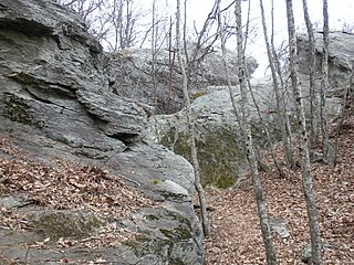
Devil's Den Nature Preserve is a 280-acre privately-owned nature preserve in Carroll County, Virginia. It showcases rugged rock formations on a ridge side, featuring a cave or rock shelter known as Devil's Den. The property was once the Robert S. Harris farm. The official address is 77 Cemetary [sic] Road, Fancy Gap, Virginia, 24328.
Lake Mooney formerly Rocky Pen Reservoir, is a 520-acre reservoir in Stafford County, Virginia. The lake has 33 miles of shore line, 40 million gallons of water enter the lake every day from the Rappahannock River. Mooney is the newest lake in Virginia.
References
- ↑ Virginia Department of Game and Inland Fisheries, http://www.dgif.virginia.gov/fishing/waterbodies/display.asp?id=90
- ↑ Virginia Department of Game and Inland Fisheries, http://www.dgif.virginia.gov/fishing/waterbodies/display.asp?id=99