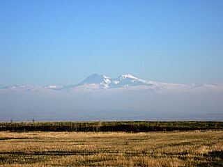
Armenia is a land of rugged mountains and extinct volcanoes, its highest point is Mount Aragats, 13,435 ft (4,095 m).
Armenia is a land of rugged mountains and extinct volcanoes, its highest point is Mount Aragats, 13,435 ft (4,095 m).
| Name | Elevation (m) | Province |
|---|---|---|
| Aragats | 4095 | Aragatsotn |
| Arailer | 2577 | Kotayk |
| Armaghan | 2829 | Gegharkunik |
| Tezh | 3101 | Triple point of Aragatsotn, Lori, Kotayk |
| Achkasar | 3196 | Border of Shirak Province and Lori |
| Urasar | 2992 | Border of Shirak Province and Lori |
| Lalvar | 2545 | Lori |
| Chatin | 2246 | Lori |
| Teghenis | 2851 | Kotayk |
| Murghuz | 2993 | Tavush |
| Artanish | 2460 | Gegharkunik |
| Kashatagh | 2901 | Gegharkunik |
| Koshadagh | 3317 | Gegharkunik |
| Azhdahak | 3598 | Gegharkunik |
| Spitakasar | 3560 | Gegharkunik |
| Geghasar | 3443 | Gegharkunik |
| Vardenis | 3520 | Gegharkunik |
| Gndasar | 2947 | Vayots Dzor |
| Kezelboghaz | 3594 | Syunik |
| Metz Ishkhansar | 3552 | Syunik |
| Khustup | 3214 | Syunik |
| Baghats | 3256 | Syunik |
| Kaputjugh | 3906 | Syunik |
| Aramazd | 3392 | Syunik |
| Urts | 2445 | Ararat |
| Ktuts | 2300 | Ararat |
| Arteni | 2047 | Aragatsotn |

Armenia is a landlocked country in the South Caucasus region of the Caucasus. The country is geographically located in West Asia, within the Armenian plateau. Armenia is bordered on the north and east by Georgia and Azerbaijan and on the south and west by Iran, Azerbaijan's exclave Nakhchivan, and Turkey.

Aragatsotn is a province (marz) of Armenia. It is located in the western part of the country. The capital and largest city of the province is the town of Ashtarak. The Statistical Committee of Armenia reported its population was 132,925 in the 2011 census.

Gegharkunik is a province (marz) of Armenia. Its capital and largest city is Gavar. Gegharkunik is inhabited by approximately 235,075 people and the majority are ethnic Armenians.
Syunik is the southernmost province of Armenia. It is bordered by the Vayots Dzor Province to the north, Azerbaijan's Nakhchivan Autonomous Republic exclave to the west, Azerbaijan to the east, and Iran to the south. Its capital and largest city is the town of Kapan. The Statistical Committee of Armenia reported its population was 141,771 in the 2011 census, down from 152,684 at the 2001 census.

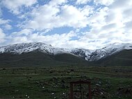
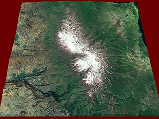
Mount Aragats is an isolated four-peaked volcano massif in Armenia. Its northern summit, at 4,090 m (13,420 ft) above sea level, is the highest point of the Lesser Caucasus and Armenia. It is also one of the highest points in the Armenian Highlands.
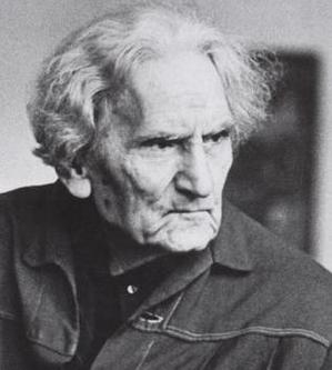
Martiros Saryan was an Armenian painter, the founder of a modern Armenian national school of painting. He was one of the members of the art association ‘The Four Arts’, which existed in Moscow and Leningrad in 1924-1931.
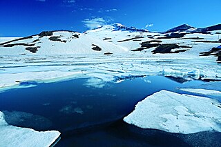
Lake Kari is a freshwater lake in Armenia located on the slopes of Mount Aragats. It is located 3,185 m above sea level and has a perimeter of 1,150 m. Its depth is up to 8 m, its volume is 375,000 m2, and it has a surface area of 0.12 km2. It formed in a u-shaped valley enclosed by moraines. The water of the lake is limpid and cold and comes mainly from precipitation. It is frozen for 8–9 months a year.

Vardenis is a town in the Vardenis Municipality of the Gegharkunik Province of Armenia. It is located in the valley of the Masrik River, on the territory of the Masrik artesian basin at 2,006 metres above sea level, near the southeastern shores of Lake Sevan. It is 170 kilometres by road east of the capital Yerevan, and 75 kilometres southeast of the provincial centre Gavar. The administrative territory of Vardenis comprises 3,006 hectares, of which 736 hectares is occupied by the town itself. Vardenis obtained its status as an urban settlement in 1995. As of the 2011 census, the population of the town was 12,685. However, as per the 2016 official estimate, the population of Vardenis is 12,600.

The Ararat Plain, called Iğdır Plain in Turkey, is one of the largest plains of the Armenian Highlands. It stretches west of the Sevan basin, at the foothills of the Gegham mountains. In the north, the plain borders on Mount Aragats, and Mount Ararat in the south.
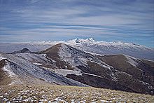
Gegham mountains are a range of mountains in Armenia. The range is a tableland-type watershed basin of Sevan Lake from east, inflows of rivers Araks and Hrazdan from north and west, Azat and Vedi rivers from south-west and Arpachai river from south. The average elevation of the Gegham mountain range is near 2500m. The range is of volcanic origin including many extinct volcanoes. The range is 70 km length and 48 km width, and stretch between Lake Sevan and the Ararat plain. The highest peak of the Gegham mountains is the Azhdahak, at 3597m. They are formed by a volcanic field, containing Pleistocene-to-Holocene lava domes and cinder cones. The highland reaches a height of 1800–2000m up to 3000m in the dividing ridge.
Musayelyan is a village in the Ashotsk Municipality of the Shirak Province of Armenia. The St. Trdat church built in 1896 is located in the village.
Nrnadzor is a village in the Meghri Municipality of the Syunik Province in Armenia, on the bank of the Aras River.
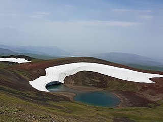
Azhdahak is a volcano in Armenia, the highest point of Gegham mountains. It has an elevation of 3,597 m above sea. It is part of the Gegham Ridge volcanic field, which last erupted at 1900 BC ± 1000 years.

A vishapakar also known as vishap stones, vishap stelae, "serpent-stones", "dragon stones", are characteristic monoliths found in large numbers in the Armenian Highlands, in natural and artificial ponds, and other sources of water. They are commonly carved from one piece of stone, into cigar-like shapes with fish heads or serpents. Supposedly they are images of vishaps, a water dragon of Armenian folklore. There are about 150 known extant vishap stelae, of which 90 are found in Armenia.

The Karabakh Plateau or Syunik Plateau is a volcanic plateau of the Lesser Caucasus, in Armenia and Azerbaijan, in the most eastern point of Armenian Highlands. It extends from the south of the Murovdag/Mrav range towards the East Sevan Range. The Hakari river separates it form the Karabakh Range. The highest point is Dəlidağ. It features a number of extinct volcanoes, the highest being Qızılboğaz.

The geology of Armenia was shaped by geological upheaval pushed up the Earth's crust to form the Armenian Plateau 25 million years ago. This created the complex topography of Armenia.
Shirak Plain, , is a plain located in the Armenian Plateau, at the northwest of Armenia. It roughly occupies almost the entire area of Shirak Province, the southwestern parts of Lori Province, as well as the northern parts of Aragatsotn Province.
The 2019–20 Armenian Cup was the 29th edition of the football competition between clubs in Armenia. FC Noah won the Cup for the first time. The tournament began on 6 September 2019 and ended on 10 July 2020.
The 2020–21 Armenian Premier League season is the 29th since its establishment.
The 2021–22 Armenian Premier League, known as the VBET Armenian Premier League for sponsorship reasons, was the 30th season of the league since its establishment.